Identifying High Risk Bridges in New Jersey

A team of researchers from New Jersey Institute of Technology have improved upon methods to identify high risk bridges in New Jersey to facilitate prioritization for repair or replacement. They have accomplished this through validating and advancing a new multi-dimensional model to analyze bridge scour and make appropriate recommendations. Bridge scour is the gradual removal of sediment around bridge abutments or piers caused by water movement, which can affect the long-term integrity of a bridge structure. By collaborating with three New Jersey consulting firms, the researchers hope to transfer their findings for statewide application.

Read a short technical brief summarizing the project background and findings (November 2017)

The researchers developed a “Scour Evaluation Model” or SEM that reflects New Jersey’s unique geological and hydrologic/hydraulic conditions while taking a more comprehensive approach than previous practices. NJDOT joins a number of other state DOTs that use a modified method for scour evaluation, as standard methods have often yielded conservative values for scour depth, or yielded disparities between predicted and observed scour.

SEM uses seven parameters to evaluate scour risk. One key parameter is the use of envelope curves, which “correlates the upper range of expected scour depth with a measurable hydraulic variable such as embankment length or pier width.” It was originally developed by USGS and original curves were based on bridge studies in 14 states. Many of the bridges were located in South Carolina’s Coastal Plain, which has a similar geology to New Jersey.

Another key parameter is determining whether a bridge has experienced a 100 year storm, and if so, how it performed. The other five include erosion resistance of streambed, bridge age, field scour observations, channel stability, and HEC-1800 scour calculations.

In their report, the team summarized the impacts of their SEM application. The bridges were rated by priority levels (1-4) based on the analysis. First, 17 bridges were evaluated using an abbreviated SEM procedure to prescreen high risk bridges. These 17 bridges were determined to be Priority 1 (high risk) or Priority 2 (medium-high risk) and in need of repair or replacement.

Secondly, the project evaluated 12 bridges fully using SEM with the participation of three consulting firms. Two of the bridges in the study were found to be Priority 1 (high risk), one bridge was found to be Priority 3 (medium to low risk) and nine bridges were found to be Priority 4 (low risk). The low risk bridges were then recommended for removal from the scour critical list.

Third, the research study was able to validate the use of “envelope curves” to evaluate scour at 15 bridges across 9 New Jersey counties with a range of characteristics and flooding histories.

The team’s goal was to accelerate the transfer of the model into statewide practice, so that it can be fully applied to New Jersey’s inventory of scour critical bridges. This was accomplished through meetings, conference calls and field visits with participating consultants.

The team’s full research and implementation process can be read in the following report:
SCOUR Evaluation Model Implementation Phase

View the team’s presentation slides from the 19th Annual NJDOT Research Showcase

RABIT: Automated Condition Assessment of Concrete Bridge Decks by Robotic System

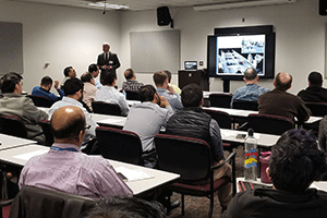
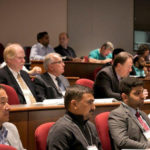
Dr. Nenad Gucunski speaking at a recent Lunchtime Tech Talk!

The April 6, 2018 Lunchtime Tech Talk featured Professor Nenad Gucunski, Director of the Center for Advanced Infrastructure and Transportation (CAIT) Infrastructure Condition Monitoring Program and chair of the Department of Civil and Environmental Engineering at Rutgers University. Dr. Gucunski spoke to a full room of NJDOT employees about the benefits of non-destructive bridge evaluation (NDE) technologies, as well as the latest advancements in the field.

The benefits of NDE are many, but ultimately the value is realized by its ability to help bridge owners make better-informed decisions regarding maintenance, repair, and rehabilitation of vital infrastructure.  New Jersey serves as the perfect laboratory for the development of such technologies, given the myriad of aging bridges in the state and the congestion that demands bridge evaluation be done quickly, but as safely as possible. Dr. Gucunski highlighted two of CAIT’s breakthrough platforms to achieve these goals, the RABIT™ and the BEAST.

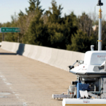
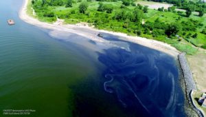
Equipped with ground penetrating radar, GPS, digital cameras, and other instrumentation to measure electrical resistivity and ultrasonic waves, the RABIT™ is a robot that can single-handedly perform in-depth bridge inspections. With these tools, the RABIT™ provides quantitative assessment of concrete bridge decks and presents the data in an intuitive manner with graphs that provide a comprehensive picture of bridge health. According to Professor Gucunski,
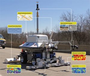
the RABIT

The RABIT

“In the past, we didn’t have a way to compile information on delamination, degradation, corrosion, precise location, visual, or load stress data all at once. Not only does RABIT™ help us validate data collected from individual machines, but it forms a meaningful picture of what’s happening inside the bridge deck in real time to help us arrest deterioration.”

This robot not only increases the speed in which data are collected and analyzed, but reduces the cost and traffic congestion associated with doing so. Most importantly, it improves the safety for workers who are no longer required to perform lengthy inspections in high traffic areas. Dr. Gucunski presented the results of various NDE surveys that had been completed by the RABIT™ from around the country, highlighting the demand and efficiency of such technologies. Furthermore the robot is able to not only evaluate the state of bridges, but can also perform minor rehabilitation repairs. When the robot sees delamination occur below the surface, it has the ability to bore a hole into the bridge and flood the cracking with a sealant that NJDOT employee Dr. Giri Venkiteela was instrumental in creating.

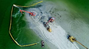
Dr. Gucunski also focused the spotlight on the BEAST, the next level of bridge deck evaluation. While the RABIT™ can be used to evaluate the current bridge inventory through safe and non-destructive means, the BEAST tackles the problem in a different way: by actively speeding up the impact and deterioration of bridges to give researchers a look how bridge systems will fare over in the future. The BEAST tests sample bridge with spans of up to 50 feet long and 28 feet wide using rapid-cycling temperature extremes, simulated precipitation, and a loading device that inflicts the same kind of beating as 24-7 heavy truck traffic. The BEAST “compresses time” and demonstrates decades of deterioration after only a few months. The BEAST offers a unique insight on the future performance of materials and structural components, supplying bridge owners information that could previously only be realized after decades of wear and tear. This technology not only helps with the design of bridges that have not yet been built, but  allows for a better understanding of how current bridges may fail and can identify the best rehabilitation and preservation techniques.
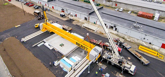
the BEAST

The BEAST

New Jersey’s infrastructure is amongst the oldest in the country, with over a third of our bridge systems deemed structurally deficient or in need of repair. Since it is logistically and financially impossible to repair every single bridge, these two technologies help expand the lifespan and performance of the bridges we have today.

Resources

View the presentation: Gucunski, N. (2018).  RABIT: Automated Condition Assessment of Concrete Bridge Decks by Robotic System

Below is a short video of the RABIT (Robotics Assisted Bridge Inspection Tool) in action (no sound).

2018 NJDOT TRB Roundtable Discussion

Below you can view 2018 presentations and session notes provided by NJDOT staff who attended the 97th Annual Meeting of Transportation Research Board (TRB), which is grouped by their bureau or unit. You can also download the entire set of presentations here: 2018 NJDOT TRB Roundtable Slides. The TRB AMOnline portal provides access to all available TRB papers and presentation slides and visual aids.

Introduction to TRB (326 KB, 11 slides)

Traffic Operations Notes (622 KB, 38 slides)

  • Automated Vehicles Symposium 2017 (Session 129)
  • Mobility of the Future Session (Session 203)
  • Regional Transportation Systems Management & Operations (RTSMO) Committee, Connected and Automated Vehicles Working Group (AHB10)
  • After Hurricanes (Session 191)
  • Physical Security Sub-committee Meeting
  • CyberSecurity Sub-committee Meeting
  • Cybersecurity Challenges for Connected and Autonomous Vehicles: Fact vs. Myth (Session 592)
  • Maintenance and Operations Workforce: Assessing the Effects of Technology and Demographics (Session 285)
  • Diets, Diamonds, and Daring New Ideas for Intersections (Session 547)
  • Vision Zero Evaluation Workshop (Session 881)
  • Next Steps in Automated Vehicles
  • Advanced Traffic Signal Performance Measure (ATSPMs)
  • Innovation in Control Delay Calculation
  • Work Zone Lane Capacity (Session 451)
  • Proactive Signal Control Systems for Congestion Mitigation on Arterial

Notes from TRB Focus Area: Connected and Autonomous Vehicles

Statewide Planning Notes (2 MB, 63 slides)

  • Connected and Autonomous Vehicles, which includes an overview of AV state legislation and developing a connected AV vision and notes on the following sessions:
    • Metropolitan Policy Considerations for Connected and Autonomous Vehicles (Part 1) (Session 265)
    • Impacts of Connected and Autonomous Vehicles on Transportation Forecasting and Planning (Session 271)
    • The Future of Transportation Infrastructure: What? Where? How? (Session 329)
    • Planning for a Future with Autonomous and Connected Vehicles (Session 406)
  • Smart Transportation: Getting Organized (Session 471)
  • International Progress Toward Vehicle-Highway Automation (Session 546)

Bureau of Research Notes (3.3 MB, 43 slides)

  • Optimizing Work Zone Lighting (Session 384)
  • Roundabout Topics: Safety, Design and Operations (Session 777)
  • Evaluation of different paints systems for over-coating exiting structural steel, Corrosion Committee (AHD45)
  • Vision Zero at a Crossroads: Identifying Challenges and Developing Partnerships to Eliminate Traffic Deaths in the United States (Session 477)
  • Competing Visions of Transportation’s Future (Session 268)
  • The Future of Transportation and Reliance on Knowledge Sharing Among Transportation Organizations (Session 461)
  • Humanizing Highway Landscape Design (Session 537)
  • Tools for the Zombie Apocalypse: Avoiding the Brain Drain in Transportation Organizations (Session 661)

Notes from TRB Session 777: Roundabout Safety, Design & Operations

Multimodal Notes (1.4 MB, 8 slides)

  • Aero Sessions:
    • Unmanned Aircraft Systems (Session 237)
    • Stating the Initiative: Aviation Programs, Funding, Support, and Development Among States (Session 372)
    • Current Trends in Aviation System Planning: System Performance and Resiliency (Session 563)
    • Essential Elements for Airport Operations: Pavement Repair, Aircraft Arresting and Anti-Icing (Session 628)
  • Maritime Sessions:
    • Where to Go with Transportation Taxes? Past evidence and future visions (Session 260)
    • Emerging Technologies: The role of LIDAR and Unmanned Aerial Systems in supporting the transportation spatial information infrastructure (Session 263)
    • Transportation Agency Data Governance and Open Data Efforts (Session 337)
    • Freight Systems and Marine Transportation Work in Progress (Session 368)
    • Marine Safety and Human Factors Committee Meeting
    • A Comparison of Existing and Potential Ferry Services in Norway, Australia, and Washington, D.C. (Session 501)
    • Freight Day, Part 1: Making Short-Haul Intermodal Work (Session 504)
    • Improving Ferry Operations and Planning with Digital Information (Session 559)


Notes from TRB Session 598: Technological Advances in Road Ecology Science

Environmental Resources Notes (2 MB, 27 slides)

  • Climate Change Response: Where Are We Now and What Happens Next? (Session 331)
  • Environmental Justice AASHTO Community of Practice, TERI Database, EJ Courses
  • Decarbonization & Greenhouse Gas Reductions: Progress, Priorities, and Research Needs (Session 466)
  • Technological Advances in Road Ecology Science (Session 598)
  • What’s Hot in State DOTs (Session 342)
  • Increasing Infrastructure Resilience through Bioenhancement (Session 629)
  • Virtual or Augmented Reality (Session 205)

Civil Rights & Affirmative Action Notes (5.3MB, 48 slides)

  • Revenue and Finance: The Uncertainty of Funding
  • Environmental Justice in Transportation Committee
  • Community Impact Assessment Committee Meeting
  • DBE Program
  • The Interstate: Mitigating Past and Current Project Impacts (Session 269)

“Mending the Divide” — Notes from Session 269: The Interstate: Mitigating Past and Current Project Impacts

Capital Program Support Notes (2.5 MB, 11 slides)

  • Public Engagement for Crisis Situations (Session 157)
  • Environmental Justice in Transportation Committee
  • Planning Process and Environmental Justice (Session 805)
  • Joint Subcommittee on Community Impact Assessment

Structural Engineering Notes (740 KB, 7 slides)

  • Truck Size and Weight: What You Need to Know (Session 120)
  • Bridging the Gap Between Non-Destructive Evaluation and Structural Health Monitoring (Session 164)

Tech Talk Recap: Smart Cities and Transportation with Kenneth Leonard

On February 20, 2018, the fifth event in the Lunchtime Tech Talk series took place and featured speaker Kenneth M. Leonard, Director of the U.S. Department of Transportation Intelligent Transportation Systems (ITS) Joint Program Office. Leonard spoke to a full crowd of attendees including NJDOT personnel. Leonard, a recognized leader in the field of ITS, focused his presentation on the USDOT Smart Cities Challenge and the way connected cities and communities could become “smart”.

The Smart Cities Council has deemed a Smart City to be one that uses information and communications technology (ICT) to enhance its livability, workability, and sustainability. Leonard explained that connected infrastructure technology can support a smart community through such things as connected vehicles, sensor-based intelligent infrastructure, smart grids, data management and urban analytics, among others. He shared an example of components of a connected city, citing that “Transportation is critical to making a city work—in commuting to work, education, entertainment, as well as shipping and receiving products”.

Leonard highlighted the Columbus, Ohio demonstration project where a $140 million investment in Smart Columbus will create the Columbus Connected Transportation Network, which will include integrated data exchange, enhanced human services, and electronic vehicle infrastructure.

Leonard suggests that smart communities produce desired outcomes that include safety enhancements and efficiency in services. The Smart Columbus project has measurable outcomes, such as: enhanced safety through reduced truck accidents, increased mobility through minimized travel times, improved employment opportunity by reaching underserved communities, and improved air quality from reduced truck congestion and increased access to EV charging stations.

Columbus was selected as the 2016 winner of the USDOT Smart Cities Challenge competition, which included the participation of 77 cities nationwide. To read about the Smart Cities Challenge, please visit: https://www.transportation.gov/smartcity

Resources

View the presentation: Leonard, K. (2018). Smart Cities and Transportation.

You can watch a video of the presentation below.

Getting through the Green: Smarter Traffic Management with Adaptive Signal Control

NJDOT Assistant Commissioner for Transportation Systems Management, C. William Kingsland, spoke about Adaptive Signal Control (ASCT) during the third Lunchtime Tech Talk hosted by the Bureau of Research on November 29, 2017.

The Federal Highway Administration (FHWA) defines ASCT as technologies that capture current traffic demand data to adjust traffic signal timing to optimize flow in coordinated traffic signal systems.  FHWA established ASCT as one of its Every Day Counts Round One initiatives in 2011-2012. New Jersey has implemented ASCT through the work of the Traffic Management Systems unit.

Assistant Commissioner Kingsland pointed out that commuters anticipate the time it will take for their typical commute routine and that reliability in travel time is important; people do not like fluctuation in the time it takes to get from A to B. When there is reliability of travel time, people’s expectations are met. ASCT effectively reduces congestion and fuel consumption, thus reducing complaints and frustration.

The ASCT system continuously learns based upon the traffic that is out there and will respond to changes in traffic patterns. Thus, the ability to adapt to unexpected changes in traffic conditions will produce improved mobility through a given area. Furthermore, as connected vehicles become more prominent, the system has the ability to gather information through Vehicle-to-Infrastructure communication and provide timely data of vehicle spacing and signal timing.

Assistant Commissioner Kingsland also provided some highlights about COAST- NJ, the management system developed by AECOM and the New Jersey Institute of Technology that is used to help decide where the ASCT systems will be placed. Using quantitative analysis, the tool ranks sections of corridors based on severity of congestion, variability of congestion, signal spacing, and traffic volume. COAST -NJ provides a classification system scoring process that encompasses 2,562 signalized intersections, 297 signalized arterial corridors, and 56 signal systems. It was officially released for use in March 2017.

During the Q&A portion of the Tech Talk, a member of the audience asked whether the system retains the collected traffic flow information to be able to look back to a certain date and time. The answer is that yes, it can. The issue, however, becomes length of records retention and where to store all of this information over the long-term.

In NJ, some of the NJDOT project locations with ASCT are along Route 130 (MP 69.79 to 74.51) with 15 intersections tied in; Route 168 (MP 6.79 to 9.72) with 11 intersections; and Route 32 (MP 0.0 to 1.20) with two intersections. Mr. Kingsland noted that Route 18 South in New Brunswick to East Brunswick is about to go online

Other agencies are also implementing ASCT. While not a NJDOT project, in the Meadowlands area there are 140 intersections tied into one ASCT system area managed by the Meadowlands Commission.

Mr. Kingsland was asked if rural areas with large distance between signals could possibly have cameras placed at intermediate sections between intersections. Kingsland replied that they certainly could, but the cost of such projects is prohibitive at this point in time.

Due to popular demand, Assistant Commissioner Kingsland presented this Tech Talk again on January 29, 2018.

Resources

Kingsland, W. (2017). Adaptive Signal Control—Getting Through The Green (Presentation).

Drone Program Takes Off in Bureau of Aeronautics

The Drone program within the Division of Multimodal’s Bureau of Aeronautics has begun to take shape as staff, funding, and a multitude of innovative ideas have come together. So what does it take to start a new and innovative NJDOT Drone program when it has never been done before? First, it starts with knowledgeable staff. A UAS (Unmanned Aerial Systems) Coordinator position was created within the Bureau of Aeronautics to lead NJDOT’s UAS initiatives. The UAS Coordinator’s role is to:

  • Provide leadership, guidance, and coordination for flight operations to Divisions
  • Ensure compliance with State and Federal Aviation Regulations
  • Ensure flight operations are based on the most current best practices
  • Coordinate FAA Airspace Waivers and ATC Authorizations
  • Develop Implementation and Staff Training Plans
  • Assist with the drafting of RFP’s for consultants
  • Keep NJDOT informed of public perception and liability

Captain Glenn Stott is the current UAS Coordinator for the NJDOT. He is a retired Canadian Air Force jet instructor, Test Pilot, and Flight Commander. Glenn is an FAA designated examiner and authorized to grant the highest level of pilot license. In addition to his aviation experience, Glenn’s understanding of emerging technologies earned him part-time positions as an Adjunct Technology Professor for both Kean and Seton Hall Universities. Glenn’s UAS background started over 20 years ago with remote control helicopters. Currently, he serves on the NASAO (National Association of State Aviation Officials) UAS Committee and is a frequent speaker regarding drone technology in the transportation industry.

Funding was the next big issue in setting up a new program of this caliber. NJDOT applied for three FHWA grants and was fortunate enough to be awarded all three. These three separate grants are: FHWA Tech Transfer Deployment Funds for a UAS Peer Exchange on Best Practices, FHWA State Transportation Innovation Council (STIC) Incentive program for equipment & training, and FHWA State Planning & Research Program for Best Practices, Policies and Procedures.

Runway 32 Taxiway construction at Eagles Nest Airport, West Creek, NJ. Photographed by Glenn Stott via drone

Runway 32 Taxiway construction at Eagles Nest Airport, West Creek, NJ. Photographed by Glenn Stott via drone

There are numerous potential areas for public use in transportation where UAS technology makes sense that many New Jerseyans may not be aware of. Some of the initiatives being explored are:

  • Traffic Incident Management
  • Structural Inspections
  • Traffic Congestion Assessment
  • Aerial 3D Corridor Mapping
  • 3D Reality Modeling from Photogrammetry
  • Emergency Response Assessment
  • Real-time Construction Project Management
  • Landfill volume calculations
  • Inspections of confined or hazardous spaces

Professional UAS operations possess many advantages over traditional methods for daily operations. Some of these advantages include a relatively low cost compared to the manpower, time and equipment traditionally used, rapid deployment, a very low carbon footprint, and the ability to operate in areas that are risky or dangerous to humans. For example, NJDOT owns and operates 250 High Mast Light Poles (HMLP) near NJ roadways. HMLPs are approximately 100-feet high, and are traditionally inspected with either binoculars or bucket trucks. While there is an inherent safety risk in performing inspections so high up near a busy roadway, UAS can alleviate this risk by providing upclose inspection of HMLPs. In addition to the safety advantage, UAS provide a higher quality inspection with closer views, higher definition photos, and with less disruption to traffic as the need for a lane closure is eliminated. To date, 241 out of 250 NJDOT HMLP inspections have been successfully completed with UAS, and photo logs have been created to identify and track problem areas. UAS structural inspection does not replace the human inspector, it is simply a tool used by the inspection team to identify potential problem areas that require closer examination.

Dredging project in Brigantine, Atlantic County. Photographed by Glenn Stott via drone

Beach Replenishment in Manasquan, NJ. Photographed by Glenn Stott via drone

NJDOT UAS projects are selected and pursued based on the opportunity to increase safety, increase efficiency, save money, and save time. Projects at this time range from collecting aerial photos over marshlands that cannot be traversed on foot, to aerial photos and videos of dredging projects at all stages in order to view the direction of the tide as well as the shoals and shallows. Drones are also being used to create 3D models that offer representation of a site and surface elevation. For example, a drone has been used to map a section of Route 26 to evaluate the potential of creating 3D maps for surface surveys. Areas are still being surveyed by hand in order to evaluate the accuracy of the drone survey elevations and calibrate the systems. 3D “Reality Modeling” with Photogrammetry provides real-world models for conceptual design, construction, and operational decisions, using simple photography rather than expensive LIDAR. 3D models created using drone Photogrammetry can be assessed and shared in CAD or GIS. The Association for Unmanned Vehicle Systems International (AUVSI) released their 2017 Economic Impact Report that estimates in the first 3 years of integration more than 70,000 jobs and 13.6$ billion economic growth for the United States. By 2025 they estimate 100,000 jobs created and an economic impact of $82 billion. As you can see, the possibilities for the use of UAS are numerous and innovative. The Bureau of Aeronautics looks forward to pursuing projects that enhance safety, efficiency, and cost-effectiveness for NJDOT in a variety of areas.

Contributed by Glenn Stott & Kinan Tadmori
Feature image (above) is a High Mast Light Pole on Route 1, Mercer County. Photographed by Glenn Stott
This article first appeared in the December 2017 CIPGA Scoop, the employee newsletter of the [NJDOT] Capital Investment, Planning and Grant Administration.
custom writings

Local Safety Peer Exchange – 1st Event

FHWA and NJDOT are holding a series of three Local Safety Peer Exchanges for municipal and county representatives to discuss local initiatives that demonstrate best practice in addressing traffic safety. The first peer exchange was held on December 6, 2017. Topics discussed included NJ safety performance targets, use of Safety Voyager, substantive vs. nominal approaches to design, systemic vs. hot spot approaches to safety, and discussion of FHWA safety countermeasures, among others. Two more events will be held in 2018.

Local Peer Exchange, December 6, 2017

Data-Driven Safety Analysis: Nominal vs. Substantive Safety

FHWA’s 2017 Update of the Proven Safety Countermeasures

Local Safety Peer Exchange

Pavement Friction Surface Treatments

Project Screening: Using Data-Based Analysis

Safety Voyager

Unmanned Aerial Vehicle (UAV) Peer Exchange at NJDOT

NJDOT held a Peer Exchange on Unmanned Aircraft Systems (UAS, also known as Drones) on October 3-5, 2017. Representatives of six state DOTs, FAA, the NJ State Police and the NJ Forest Fire Service met to discuss best practices, policies and procedures, current projects, research studies, funding sources, state UAS legislation, and common challenges. The meeting resulted in insights on key topics such as data management and privacy, regulation of airspace, training requirements, public education, and the continued exchange of best practice and research among state DOTs.

On October 25, 2017, UAS Coordinator, Glenn Stott spoke on the topic at the NJDOT Research Showcase. To learn more, see his presentation.

CIPGA Works!

The Capital Investment Planning and Grants Administration (CIPGA) Works! Group hosts lunchtime talks on a variety of topics to brief staff on the mission, roles, and responsibilities of operating units.

Recent presentations are available below.

For more information, visit the CIPGA Works! site on NJDOT intranet.

Bicycle & Pedestrian Programs

Bureau of Research

Capital Investment Planning & Development

Capital Program Coordination

Environmental Resources

Freight Services

Local Aid & Economic Development

Maritime Resources

Multimodal Grants, Programs & Aeronautics

NJ State Transportation Innovation Council

Park & Ride Program

Performance Management

Roadway Data & Crash Records Unit

Statewide Planning

Technical Analysis Unit

Traffic & Technology Section

Transportation Data & Safety

More than a Pretty Face(ade): Meeting Safety and Historic Requirements in Concrete Barriers

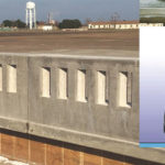
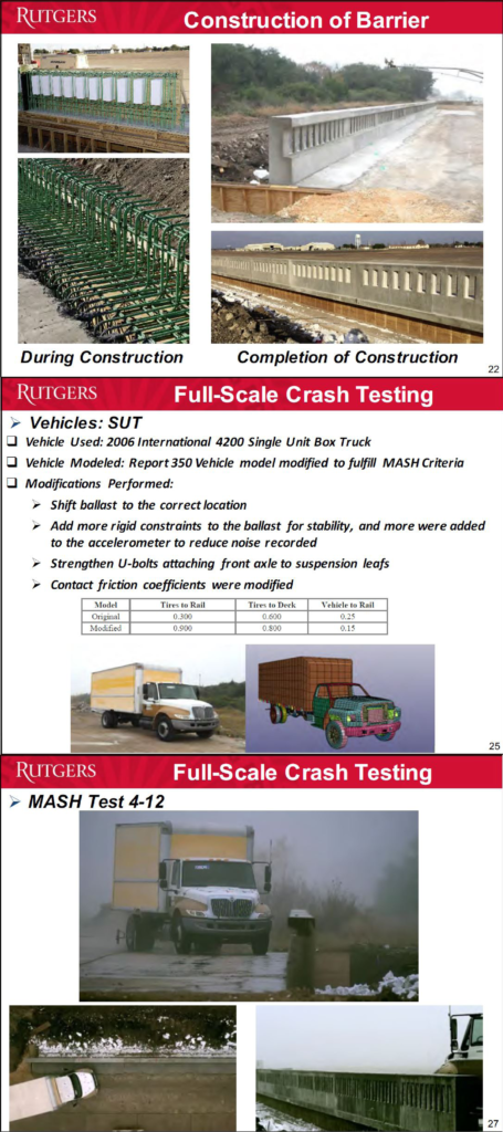
Recently, the Rutgers Infrastructure Monitoring and Evaluation (RIME) Group, a multi-modal transportation infrastructure research and education facility, was tasked to develop an open-faced concrete balustrade design that meets the aesthetic requirements of the Historic Preservation Office (HPO) and the safety requirements of FHWA. The RIME research team used computer simulation—detailed finite element analysis via LS-DYNA—and full-scale crash testing according to MASH TL-4 safety performance criteria. The result was a historical and crash-tested parapet for the Pulaski Skyway that can be used to replace similar barriers nation-wide while maintaining safety and retaining its aesthetic shape.

Dr. Hani Nassif, Professor of Civil and Environmental Engineering at Rutgers University and the lead Principal Investigator, spoke about the project at NJDOT’s Bureau of Research Lunch Session, on Monday, July 17. His talk, which is part of an ongoing Tech Talk series, gave an overview of the design, modeling and crash testing of open-faced concrete barriers, a study which started three years ago, spurred by a 2011 change in AASHTO requirements adopted by FHWA. This was the first completed study with these new requirements, partly due to cost—it costs a minimum of $250,000 to complete each crash test—and partly because the HPO was reluctant to replace parts of the Pulaski Skyway until recently preferring to preserve and redesign the current balustrade.

The study had a significant modeling component conducted using the LS-DYNA simulation program, a program that analyzes the nonlinear response of structures. Next, RIME did a parametric study before the physical testing began. The function of the new barrier is to bring the truck back into the lane, so the physical tests had a box truck, pickup truck, and sedan hit the barrier joints specifically, but at different angles. In all three instances, the vehicles were controlled and redirected back into traffic.

The result was that the testing was successful and met MASH requirements and the new barrier is in queue for approval by the FHWA. Other conclusions from the study are that dynamic finite element modeling is a good tool, and a computer simulation validated with full-scale test data can replace a full-scale test.  Dr. Nassif noted that one future task is to design a guardrail transition terminal, checking the barrier with MASH TL5 using LS DYNA Model and then crash test if the models provide acceptable results.

The Lunchtime event, the second installment of the Tech Talk series, was well-attended with about 40 NJDOT and industry professionals.  For those present, the event provided opportunities for back and forth Q&A, including a discussion about damage to the infrastructure based on the test barrier specifications. One attendee commented that he was looking forward to follow-up on the project regarding FHWA’s response.

The Rutgers Infrastructure Monitoring and Evaluation (RIME) Group is a multi-modal transportation infrastructure research and education facility that focuses on structural health monitoring, advanced concrete materials, finite element analysis, traffic and transportation analysis, and life cycle cost analysis.   

The Project Team included:
Lead PI: Hani Nassif, Ph.D., Rutgers University
Co-PIs: Malcolm Ray, PE, Ph.D., Chuck Plaxico, Ph.D., Roadsafe LLC
Research Affiliates: Andrew Wassef, Dan Su, Ph.D., Chaekuk Na, Ph.D.
Giri Venkiteela served as NJDOT Project Manager

Resources

Nassif, H. (2017). More than a Pretty Face(ade): Meeting Safety & Historic Requirements in Concrete Barriers (Presentation).