Did you know...


Did you know...
Did you know...

Did you know...

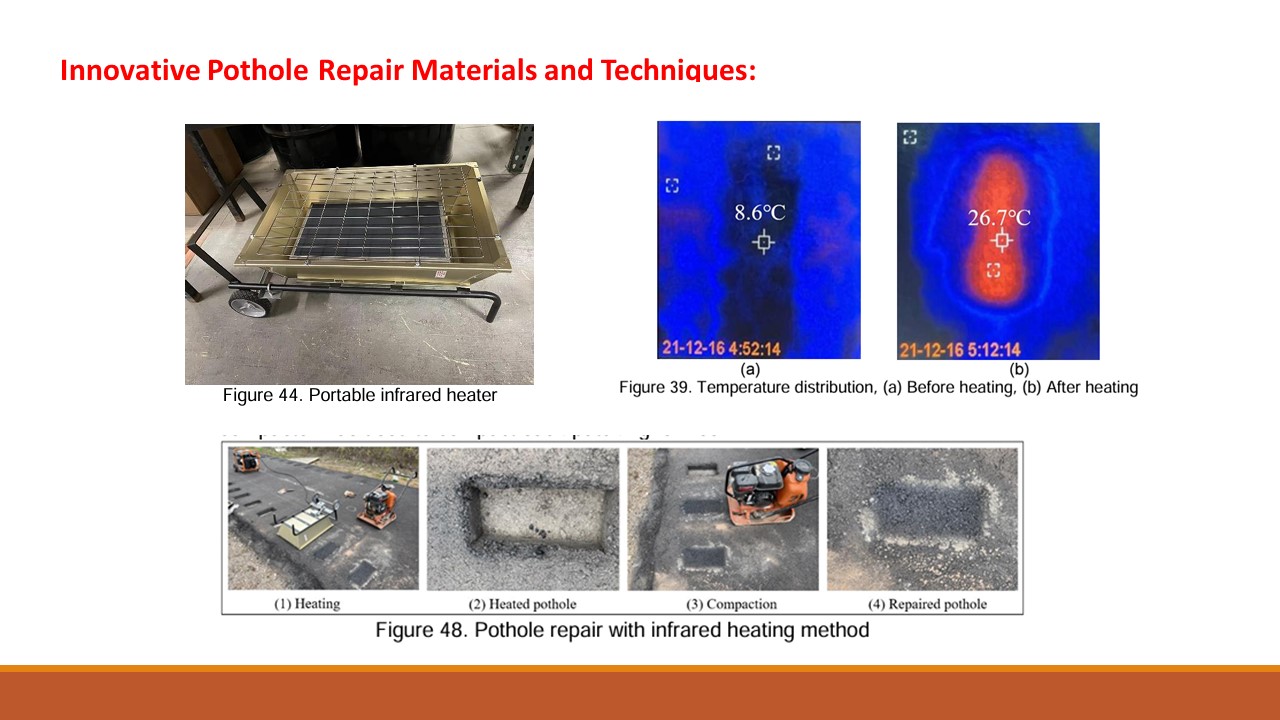
A recently completed NJDOT research study, Innovative Pothole Repair Materials and Techniques, tested several new techniques and materials that could improve the cost-effectiveness of pothole repairs in New Jersey. Phase I of the research project, led by Professors Hao Wang and Husam Najm of Rutgers University, evaluated new methods for both asphalt and concrete structures. Pothole repair is one of the primary maintenance activities for highway agencies, generating significant costs and resource commitments. Cost-effective pothole repair methods can reduce or eliminate the possibility of re-patching and save future repair costs.
Asphalt pavement is continuously subjected to vehicular and environmental loading throughout its lifecycle, leading to the inevitable occurrence of distresses such as cracking, rutting, raveling, potholes and so on. Among these distresses, potholes are critical as they can disrupt traffic, impose risks to safety, and cause costly vehicular damage for vehicle operators.
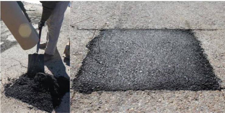
Pothole repair is a primary maintenance activity for highway agencies. Typically, cold mix asphalt is used for emergency repair and hot-mix asphalt (HMA) for traditional repairs. Usual pothole repair methods include throw and go (roll), edge seal, semi-permanent, spray injection, and full depth repair. Among them, throw and go (roll) method using HMA has been adopted by most transportation agencies for surface patching. However, this common practice largely relies on the usage of HMA. Although the quality of the asphalt patch can be ensured, it presents environmental concerns due to the energy consumption and environmental footprint involved in producing new HMA. To mitigate the impact on the environment, reduce cost and conserve energy, recycled asphalt pavement (RAP) has been widely used as a highly desirable material. The addition of recycled asphalt pavement (RAP) in asphalt mixtures can bring numerous economic and environmental advantages.
This study sought to investigate an innovative approach to pothole repair using HMA with RAP and preheating. The study investigated two aspects: First, the performance of HMA with different RAP contents were evaluated through laboratory tests to select the most appropriate content. Second, the in-site strength of pothole repair was evaluated with field cores to quantify the benefits of repair quality due to recycled material and preheating.
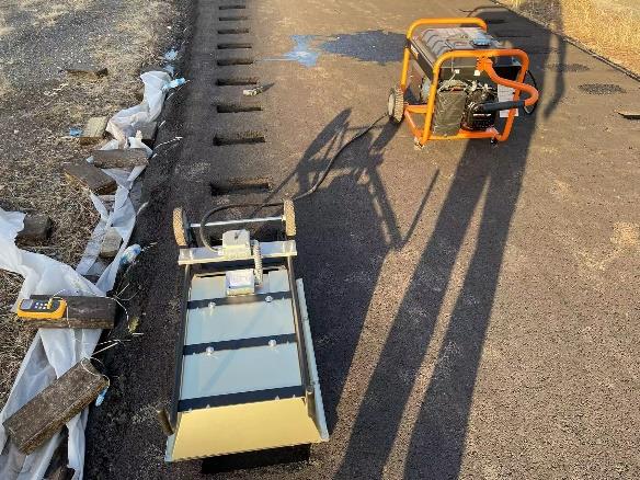
Both microwave heating and infrared heating were tested, with varying results. Microwave heating was able to warm both the surface and internal materials of the pavement, however, its efficiency was low and the rate of temperature increase was insufficient. Conversely, the infrared heating method proved adept at rapidly heating the top edges and bottom surface of the pothole to high temperatures and was used successfully in pothole repair.
Further tests were carried out adding RAP to HMA patching materials. The results showed that there was greater abrasion loss, reduced IDT (indirect tensile strength), and interface shear strength of patching material had less resistance to moisture as RAP content increased. Nonetheless, with the application of preheating, the overall performance of HMA containing 30 percent RAP was satisfactory, proving that it is feasible to use RAP material for pothole repair.
Similar to asphalt pavement, concrete structures are prone to deterioration due to vehicles and weathering. Cracks can develop which lead to further deterioration due to chloride infiltration. Thus, a good repair is necessary for maintaining concrete structures. An ideal repair material should be easy to work with under different weather conditions, be fast setting, and possess good durability. Rapid-setting cementitious patch repair materials are popular for repairing small concrete damage and providing a functional repair within few hours.
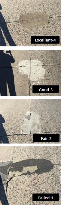
Based on extensive literature research and several NJDOT practices, three formulations were chosen as the best performing candidates. Workability, strength, and restrained shrinkage cracking of the formulations were investigated. The restraint shrinkage test protocol simulated upper and lower limits of restraint that a repair material undergoes in real applications. The repairs were also cast and placed in external environmental conditions to expose them to natural weathering actions. The cracking behavior was evaluated including cracking spacing and maximum crack width
The investigation led to the identification of three formulations that did not crack for a period of 10 months in field exposure to NJ climate conditions. Typically, rapid set formulations do not shrink after 6 months. The formulations that did crack revealed that an addition of 1 percent of PVA fibers could significantly reduce the maximum crack width. The maximum crack widths observed in all the formulations were an order of magnitude less than the maximum allowable crack width specified by NJDOT (1/32″).
The research projects were completed at a time when pothole repairs have attracted critical attention from motorists and legislators within the state. In the current legislative session (2024-2025), the New Jersey State Senate voted unanimously to advance a bill that is intended to address concerns about pothole damage to roads and bridges in the Garden State.
The NJ Senate bill, S862, would require the state DOT to include information about pothole repair projects and their cost in the annual report. The additional information would include reporting on the number of repair projects going on around the state and their cost. The bill includes a separate provision that would require a lifecycle cost analysis to be conducted. The information would be required to be made available to the public on the NJDOT’s website. An identical bill, A2596, was introduced in the NJ Assembly during the legislative session.
The research project is not only primed to inform the serious legislative issues being raised in Trenton but was recently recognized by the American Association of State Highway Officials (AASHTO) for its contribution to innovation. Every year, the High Value Research Task Force of AASHTO Research Advisory Committee (RAC) holds a national competition to find “high value” research projects throughout the country. In 2024, the Innovative Pothole Repair Materials and Techniques research project was recognized in the Maintenance, Management, and Prevention supplemental category, as described here.
Wang, Hao, and Xiao Chen. “Innovative Pothole Repair Materials and Techniques Volume I: Asphalt Pavement.” (2024). Final Report. Retrieved here.
Wang, Hao, and Xiao Chen. Innovative Pothole Repair Materials and Techniques Volume I: Asphalt Pavement. (2024). Technical Brief. Retrieved here.
Najm, Husam, Bala Balaguru, Hao Wang, Hardik Yagnik, and Alissa Persad. “Innovative Pothole Repair Materials and Techniques Volume II: Concrete Structures.” (2024). Final Report. Retrieved here.
Najm, Husam, Bala Balaguru, Hao Wang, Hardik Yagnik, and Alissa Persad. “Innovative Pothole Repair Materials and Techniques Volume II: Concrete Structures.” (2024). Technical Brief. Retrieved here.
Asphalt Pavement Pothole Repair with Recycled Material and Preheating. Presentation at NJDOT Research Showcase by Xiao Chen and Hao Wang. Retrieved here (Presentation) and here (Recording).

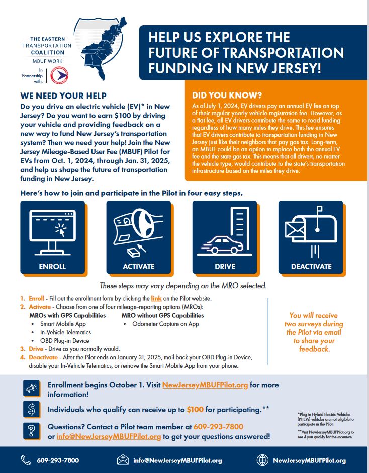
If you live in New Jersey and drive an electric vehicle (EV),* you are invited to participate in the four-month New Jersey Mileage-Based User Fee (MBUF) Pilot for EVs. The New Jersey Department of Transportation (NJDOT) and The Eastern Transportation Coalition (Coalition) are looking for EV owners to share their opinions on an MBUF system and the future of New Jersey’s transportation funding.
The state and federal gas taxes have been a main source of transportation funding for more than one hundred years. As newer vehicles are going farther on less fuel and some have stopped using fuel at all, drivers are contributing less per mile to transportation funds. The Coalition is partnering with NJDOT to explore an MBUF, where each EV driver would contribute to our transportation system based on the miles they drive instead of the annual EV fee enacted in July 2024.
The Pilot is easy to join and free to participate in, and there are strict privacy measures in place to safeguard your data.
**Notice: Enrollment in the New Jersey Mileage-based User Fee Pilot for Electric Vehicles is now closed.**
Enrollment for the Pilot begins October 1, 2024
Visit NewJerseyMBUFpilot.org to learn more.
*Plug-in Hybrid Electric Vehicles (PHEVs) are not eligible to participate in the Pilot.

The Bureau of Research, Innovation and Information Transfer (BRIIT) is active in many national transportation efforts, including the American Association of State Highway Transportation Officials (AASHTO). Dr. Giri Venkiteela, Research Scientist, BRIIT, is the Vice Chair of Region 1 of AASHTO’s Research Advisory Committee (RAC) that serves the Special Committee on Research & Innovation (R&I).
In late July 2024, he attended the RAC’s National Meeting in Columbus, Ohio and accepted two awards on behalf of the New Jersey Department of Transportation.
Every year, the High Value Research Task Force of AASHTO RAC holds a national competition to find four “high value” research projects from each of the four AASHTO regions in the country. In 2024, two research projects sponsored and managed by the New Jersey Department of Transportation were recognized nationally with awards.
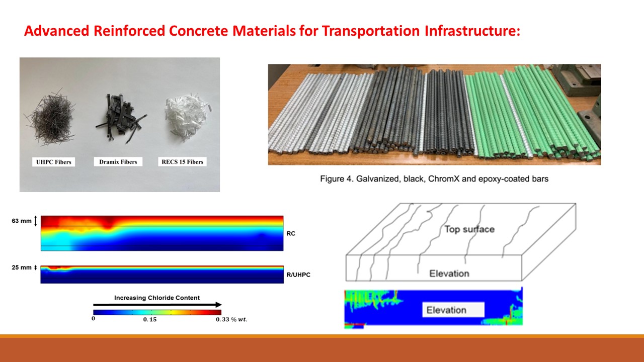
The first project, Advanced Reinforced Concrete Materials for Transportation Infrastructure, was recognized as one of top 16 projects in the country and was managed by Dr. Venkiteela. The Principal Investigator for the study was Dr. Matthew Bandelt from the New Jersey Institute of Technology (NJIT) and championed by NJDOT’s Bureau of Materials.
Transportation infrastructure systems must resist conditioning from the natural environment and physical demands from service loading to meet the needs of users across the state. Reinforced concrete, which is widely used in bridge decks, pavements, super- and substructures, and other systems, deteriorates under environmental conditioning due to electro-chemical processes that cause expansive mechanics stresses at various length scales (e.g., reinforcement corrosion, freeze-thaw, etc.), leading to costly and timely durability and maintenance challenges.
The project report, which provides a background on the state-of-the-art of advanced reinforced concrete materials that are being investigated to improve reinforced concrete transportation infrastructure. A series of experimental and numerical research activities were then carried out to assess the mechanical properties and long-term durability of these systems. Results show benefits across a range of metrics and have the potential to substantially improve the in-service behavior of reinforced concrete transportation infrastructure.
The second project, Innovative Pothole Repair Materials and Techniques, was recognized in the Maintenance, Management, and Prevention supplemental categories and was also managed by Dr. Venkiteela. Separate research reports were prepared for asphalt (Volume I) and concrete structures (Volume II). The Principal Investigator for the study was Dr. Hao Wang from Rutgers-Center for Advanced Infrastructure and Transportation.
Pothole repair is one of the most important and frequent maintenance activities for highway agencies. Significant amounts of costs and resources are spent in pothole repair for material, labor, equipment, and traffic control. Cost-effective pothole repair methods can reduce or eliminate the possibility of re-patching and save future repair costs. The good condition of pothole repair with less cracking will also prevent reflective cracking when asphalt overlay is placed. Preheating the excavated pothole prior to repair has been found to improve the interface bonding between existing pavements and hot filling material, which can help enhance the overall performance of asphalt patches.
The long lifespan of a durable patch will reduce travel delay due to work zone and safety risk of highway users and workers. They will better preserve the condition of highway infrastructure and provide better service to the traveling public. The feasible usage of recycled materials can reduce the production of new material, which can contribute towards a more sustainable approach of roadway repair with economic and environmental benefits.
Additional information about the research teams for each research project and links to Final Reports, Technical Briefs, and select presentations given at the NJDOT Research Showcase or at Lunchtime Tech Talk can be found in the resources section below.
Bandelt, Matthew J., Matthew P. Adams, Hao Wang, Husam Najm, Andrew Bechtel, Seyed Masoud Shirkorshidi, and Jin Fan. Advanced Reinforced Concrete Materials for Transportation Infrastructure. No. FHWA NJ-2023-003. New Jersey. Department of Transportation. Bureau of Research, 2023. Final Report. Retrieved here.
Bandelt, Matthew J., Matthew P. Adams, Hao Wang, Husam Najm, Andrew Bechtel, Seyed Masoud Shirkorshidi, and Jin Fan. Advanced Reinforced Concrete Materials for Transportation Infrastructure. No. FHWA NJ-2023-003. New Jersey. Department of Transportation. Bureau of Research, 2023. Technical Brief. Retrieved here.
Lunchtime Tech Talk! Webinar: Advanced Reinforced Concrete Materials for Transportation Infrastructure. Webinar. Presentations by Matthew Bandelt and Matthew Adams. Retrieved here.
Wang, Hao, and Xiao Chen. “Innovative Pothole Repair Materials and Techniques Volume I: Asphalt Pavement.” (2024). Final Report. Retrieved here.
Wang, Hao, and Xiao Chen. Innovative Pothole Repair Materials and Techniques Volume I: Asphalt Pavement. (2024). Technical Brief. Retrieved here.
Najm, Husam, Bala Balaguru, Hao Wang, Hardik Yagnik, and Alissa Persad. “Innovative Pothole Repair Materials and Techniques Volume II: Concrete Structures.” (2024). Final Report. Retrieved here.
Najm, Husam, Bala Balaguru, Hao Wang, Hardik Yagnik, and Alissa Persad. “Innovative Pothole Repair Materials and Techniques Volume II: Concrete Structures.” (2024). Technical Brief. Retrieved here.
Asphalt Pavement Pothole Repair with Recycled Material and Preheating. Presentation at NJDOT Research Showcase by Xiao Chen and Hao Wang, Retrieved here (Presentation) and here (Recording).

The New Jersey Department of Transportation (NJDOT) Research Library offers valuable assistance in supporting various research tasks and for accessing resources. This article highlights recent publications from the American Association of State Highway and Transportation Officials (AASHTO), as well as publications indexed in the TRID database. For a background on AASHTO standards and the TRID database, please see our earlier “Did You Know?” article.
Two recent AASHTO publications of note are a print version of the 11th edition of the Manual on Uniform Traffic Control Devices for Streets and Highways (MUTCD) and the 2024 edition of AASHTO’s “Materials Standards” (published electronically).
The 11th edition of the MUTCD was published by the Federal Highway Administration (FHWA) in December 2023 and is available as a free PDF download. It supersedes the previous 10th edition, published in 2009.
The new edition is also available in print format from the NJDOT Library, indexed and printed by AASHTO, in association with the American Traffic Safety Services Association and the Institute of Transportation Engineers. Users must register for a New Jersey State Library card in order to borrow any materials.
On July 31, AASHTO released the Standard Specifications for Transportation Materials and Methods of Sampling and Testing, and AASHTO Provisional Standards, 44th Edition—2024, commonly referred to as the AASHTO “Materials Standards.” These standards contain specifications, recommended practices, and test methods commonly used in the construction of highway facilities. Provisional standards are also published to allow practitioners to use them early in the research or development phase. In addition to revisions to harmonize industry standards, update technology, and generally improve the standards, the 44th edition includes 15 conversions to dual units and more updates to temperature-measuring devices.
The Materials Standards are available in three files on the Research Library’s SharePoint site. In addition to those standards, the following AASHTO reports and standards, published in 2024, are available to NJDOT employees upon request:
The Research Library has compiled a brief scan of the TRID database search on the reduction of emissions of greenhouse gases and carbon. There is an extraordinary growth in projects underway and recently completed research in transportation, covering a range of policy, planning, environment, materials, construction, multi-modal operations, and vehicle equipment, fuels and technology areas. Selected results from the past 6-12 months, focusing on surface transportation in the United States, are listed here:
Effect of Carbon-Negative Carbon Black on Concrete Properties
https://trid.trb.org/View/2389221
Evaluating Carbon Reduction in Project Selection and Planning
https://trid.trb.org/View/2329694
Shaping Automated Vehicle Behaviors in Mixed Autonomy Traffic to Benefit All Road Users and Reduce Greenhouse Gas Emissions
https://trid.trb.org/View/2350815
Advancing Methods to Evaluate Greenhouse Gas Emissions During Transportation Decision Making and Performance Management
https://trid.trb.org/View/2381725
Shifting Gears to Sustainability: A Deep-Dive into Solar-Powered Bike Pathways
https://trid.trb.org/View/2373992
Advancing Active Transportation Project Evaluation
https://trid.trb.org/View/2313957
Impacts of Remote/Hybrid Work and Remote Services on Activity and Transportation Patterns
https://trid.trb.org
U.S. Department of Transportation. DOT Report to Congress: Decarbonizing U.S. Transportation. July 2024. https://trid.trb.org/View/2404234
Mullin, Megan; Feiock, Richard C; Niemeier, Deb. Climate Planning and Implementation in Metropolitan Transportation Governance. Journal of Planning Education and Research, Volume 44, Issue 1, 2024, pp 28-38. https://trid.trb.org/view/1936743
Jeong, Minseop, Jeehwan Bae, and Gayoung Yoo. “Urban roadside greenery as a carbon sink: Systematic assessment considering understory shrubs and soil respiration.” Science of the Total Environment 927 (2024). https://trid.trb.org/View/2377597
National Academies of Sciences, Engineering, and Medicine. “Considering Greenhouse Gas Emissions and Climate Change in Environmental Reviews: Conduct of Research Report.” (2024). https://trid.trb.org/View/2404015
Kelly, Jarod C., Taemin Kim, Christopher P. Kolodziej, Rakesh K. Iyer, Shashwat Tripathi, Amgad Elgowainy, and Michael Wang. Comprehensive Cradle to Grave Life Cycle Analysis of On-Road Vehicles in the United States Based on GREET. No. 2024-01-2830. SAE Technical Paper, 2024. https://trid.trb.org/View/2367212
Ashtiani, Milad Zokaei, Monica Huang, Meghan C. Lewis, Jordan Palmeri, and Kathrina Simonen. “Greenhouse Gas Emissions Inventory from Roadway Construction: Case Study for the Washington State Department of Transportation.” Transportation Research Record (2024). https://trid.trb.org/View/2352361
Zuzhao Ye, Nanpeng Yu, Ran Wei. Joint planning of charging stations and power systems for heavy-duty drayage trucks, Transportation Research Part D: Transport and Environment, Volume 134, 104320 (2024). https://trid.trb.org/View/2408518
Lopez, Sarah, Lawrence Sutter, R. Douglas Hooton, Thomas Van Dam, Allison Innis, and Kevin Senn. “Breaking Barriers to Low Carbon Concrete Pavements.” Transportation Research Record (2024). https://trid.trb.org/View/2387006
Dugoua, Eugenie; Dumas, Marion. Coordination dynamics between fuel cell and battery technologies in the transition to clean cars. Proceedings of the National Academy of Sciences, Volume 121, Issue 27, 2024, e2318605121. https://trid.trb.org/view/2399820
Jung, Philipp Emanuel; Guenthner, Michael; Walter, Nicolas. Guided Port Injection of Hydrogen as an Approach for Reducing Cylinder-to-Cylinder Deviations in Spark-Ignited H2 Engines – A Numerical Investigation. SAE Technical Paper, 2024. https://trid.trb.org/view/2397724
Wallace, Julian; Mitchell, Robert; Rao, Sandesh; Jones, Kevin; Kramer, Dustin; Wang, Yanyu; Chambon, Paul; Sjovall, Scott; Williams, D. Development of a Hybrid-Electric Medium-HD Demonstrator Vehicle with a Pent-Roof SI Natural Gas Engine. SAE Technical Paper, 2024. https://trid.trb.org/view/2397750
Wine, Jonathan; Ahmad, Zar Nigar; McCarthy, Jr., James; Prikhodko, Vitaly; Pihl, Josh; Tate, Ivan; Bradley, Ryan; Howell, Thomas. On Road vs. Off Road Low Load Cycle Comparison. SAE Technical Paper, 2024. https://trid.trb.org/view/2367799
Please contact the NJDOT research librarian, Eric Schwarz, MLIS, at (609) 963-1898, or email library@dot.nj.gov for assistance in your transportation research, or to customize your searches in TRID and other databases.
The Special Libraries Association (SLA) recently announced that its 2024 Innovation Award recipient was Eric Schwarz, NJDOT’s Research Librarian, for his archival research work on the New Jersey DOT Memorial Wall. The SLA Transportation Community Board unanimously approved the nomination and a plaque, sponsored by National Rural Transit Assistance Program (RTAP), was provided in acknowledgement of the achievement. News of the award winners was announced via the National Transportation Knowledge Network (NTKN) Blog. The award will be officially announced at the SLA Annual Conference in Rhode Island later this month.

The SLA’s award announcement notes the following:

Earlier this year, Eric gave a “Lunch and Learn” presentation to NJDOT employees that provided information about NJDOT’s Digitization Project along with the poster presented at the 2024 TRB Annual Meeting,
More information about the online resources and historical documents that have been compiled with support from about Transportation Research and Connectivity Pooled Fund Study Digitization Project (TPF-5(442)) study were shared during the presentation.
New Jersey’s Build a Better Mousetrap Competition is currently underway!
The competition provides a great opportunity to share your ingenious and implemented solutions in transportation with others in New Jersey and across the country. These innovations can range from the development of tools and equipment modifications to the implementation of new processes that increase safety, reduce cost, and improve efficiency of our transportation system.
We are looking for submissions from employees of any local, county or state public agency, including the New Jersey Department of Transportation and NJ TRANSIT that have developed new solutions to problems or found better ways of doing things.
Winners will be chosen in two categories: Operations and Organizational Improvement. This competition is sponsored by the Federal Highway Administration’s Local Technical Assistance Program and Tribal Technical Assistance Program, and local public agency winners will be entered in the annual National LTAP/TTAP Conference.
A state winner in each category will also be selected and presented at the Annual NJDOT Research Showcase later this fall. The deadline for submissions has been extended to August 15, 2024.
New Jersey’s “Route 71 Over Shark River Road Diet Project” in Monmouth County was recognized with the “Bold Steps” Award in the Federal Highway Administration’s national competition last year as described here.
There is still time to share your ingenious solutions! Past examples of NJ’s recognized BABM award winning entries can be found here. More information about how to enter the competition and to download an entry form can be found here.

Enhancing Performance with Internally Cured Concrete (EPIC2) is one of FHWA’s innovations promoted in the seventh round of the Every Day Counts (EDC) program.
FHWA’s Innovation Spotlight video introducing the innovation for the Round 7 launch and a series of online training videos are shown below. The FHWA’s Center for Accelerating Innovation, EDC-7 EPIC2 page provides links to several videos and links to other supporting research, model specifications and technical assistance resources.
Innovation Spotlight: Enhancing Performance with Internally Cured Concrete (EPIC2)
FHWA Concrete Clips: Internal Curing Video
Expanded Shale, Clay, and Slate Institute (ESCSI) Internal Curing Videos
Internal Curing Prepared for the National Concrete Consortium Webinar Series
Oregon DOT’s Strategy to Implement Internal Curing webinar and presentation slides.
Implementation of Internal Curing by a Local Agency webinar and presentation slides. The webinar, held on October 29, 2024, featured speakers from Louisiana Transportation Research Center and the Lafayette, LA City-Parish Consolidated Government. The webinar highlighted the local agency’s positive experience with IC and the process involved in adding IC to bridge deck construction.