TRB Publications (May-June 2022)

The following is a list of research published by the Transportation Research Board (TRB) between May 1, 2022 and June 30, 2022. Current articles from the TRB may be accessed here. 


Image reads: Pavements

Point of View: The Preserved Road Ahead

Effective Pavement Preventive Maintenance with Micromilling Practices

Transforming Pavement Preservation

Essential Specifications for Pavement Preservation, Maintenance, and Rehabilitation

Pavement Rehabilitation: Case Examples from Missouri and Virginia

Implementing Pavement Preservation: A Case Example in Raleigh, North Carolina

Maintenance and Longevity of Longitudinal Joints

Pavement Maintenance and Rehabilitation: Teaching the Next Generation

Thinking Local: Pavement Management Practices for County Agencies

Pavement Preservation, Maintenance, and Rehabilitation

Short- and Mid-Term Loose Mix Conditioning Protocols for Asphalt Overlay Balanced Mix Design and Quality Control and Quality Acceptance

Evaluating Impact of Corrected Optimum Asphalt Content and Benchmarking Cracking Resistance of Georgia Mixtures for Balanced Mix Design Implementation

Examples of Successful Practices with State Implementation of Balanced Design of Asphalt Mixtures

Development and Verification of Sample Reduction Method for Rubberized Asphalt Mixtures

Performance Evaluation of Pelletized Solid Polymer Modified Asphalt Mixtures

Impact of Improved Density on Pavement Design Response for Low-Volume Roads/Non-Primary Routes

Development of a Performance-Based Approach to Asphalt Emulsion Selection for Cold In-Place Recycling Applications

Multi-Level Laboratory Performance Evaluation of Conventional and High Polymer-Modified Asphalt Mixtures

Validation of Performance-Based Specifications for Surface Asphalt Mixtures in Virginia

Data Mining Statewide Department of Transportation Volumetrically Designed Asphalt Mixture Records

Balanced Mix Design Benchmarking of Field-Produced Asphalt Mixtures in Maine, U.S.

Precision Estimates and Statements for Performance Indices from the Indirect Tensile Cracking Test at Intermediate Temperature

Field Performance Evaluation of High Polymer-Modified Asphalt Concrete Overlays

Recycled Polyethylene Modified Asphalt Binders and Mixtures: Performance Characteristics and Environmental Impact

Proposed Changes to Asphalt Binder Specifications to Address Binder Quality-Related Thermally Induced Surface Damage

Effectiveness of Soy Methyl Ester-Polystyrene as a Concrete Protectant on Mitigating the Chemical Interaction between Cement Paste and Calcium Chloride

Integrated Vehicle–Tire–Pavement Approach for Determining Pavement Structure–Induced Rolling Resistance under Dynamic Loading

Performance Engineered Concrete Mixtures: Implementation at an Interstate Rigid Pavement Project

Environmentally Tuning Asphalt Pavements Using Microencapsulated Phase Change Materials

Evaluating the Performance of Concrete Overlays in Missouri

Comparative Analysis of Laboratory and Prototype Models of Pervious Concrete Mixes Containing Reclaimed Asphalt Pavement Aggregates

Evaluation of Full-Depth Reclamation and Cold Central-Plant Recycling Mixtures for Laboratory Compaction, Mechanistic Response, and Performance Properties

Chemical and Rheological Characterization of Asphalt Binders: A Comparison of Asphalt Binder Aging and Asphalt Mixture Aging

Influence of Seed Layer Moduli on Backcalculation Procedure and on Overlay Design of Flexible Pavements

Statistical Analysis Framework to Evaluate Asphalt Concrete Overlay Reflective Cracking Performance

Evaluation of High Los Angeles Abrasion Loss Aggregate in Stone Matrix Asphalt


Trenton MOVES and the SmartDrivingCARS Summit

Trenton MOVES Display Image. CARTS.

On February 11, 2022, New Jersey Department of Transportation (NJDOT) awarded a $5,000,000 Local Transportation Project Fund Grant to the City of Trenton to support the Trenton Mobility and Opportunity: Vehicles Equity System (MOVES) project. The core vision, goals and features of the project - an autonomous vehicle transportation system capable of serving 90,000 Trenton residents and commuting workers -- were outlined in a Request for Expressions of Interest (RFEI) issued in December 2021.

The system is expected to comprise 100 autonomous, electric shuttle vehicles and 50 kiosks and will operate solely as an on-demand system, with no fixed routes or schedules. The vehicles will be handicapped accessible and accommodate up to eight passengers.

Kiosks will be located at popular locations and high-density residential/commercial areas within a five-minute walk by over 90 percent of Trenton residents. Riders will be able to hail the vehicles through mobile devices or through an interface at each kiosk for those lacking access to a mobile device.

Through its partnership with Princeton University and the Corporation for Automated Road Transportation Safety (CARTS), NJDOT supported an extensive public outreach process to support the development of the RFEI. This outreach revealed several notable current conditions: 70 percent of Trenton households have one or no personal vehicle; due to land use decisions of prior decades and the lack of frequent bus service, seniors have to take circuitous bus rides, schedule an access-a-ride in advance, or walk significant distances to access destinations for everyday needs; and high school students living within two miles of the high school were without access to a bus because of a national bus driver shortage. The new system is intended to alleviate these and other limitations of the current transportation structure. The public engagement informed the RFEI and generated five goals for the program.

Goals of the Program

Safety

Autonomous vehicles can provide improved safety as they are not subject to human fallibilities, such as driving distracted or speeding. Some acclimation will be needed to ride in a vehicle with no driver. For the first two years of the project, vetted safety hosts will be on the vehicles to assist riders in understanding and navigating the system. The project will initially be limited to its operational design domain while on public roads.

NJ State Transportation Innovation Council Discusses Trenton MOVES at their 1st Quarterly Meeting of 2022

Equity

A significant majority of Trentonians live in Areas of Persistent Poverty, own one or no cars, and spend a high proportion of their income on transportation within the City. The program must serve the transportation needs of all Trenton residents, particularly those with limited transportation access due to economic or physical hardships. The service will aim to be inclusive both in terms of communities served and user experiences.

Affordability

The program will aim to be both low cost to the rider and the taxpayer. As NJDOT wants it to be both equitably and fiscally viable long into the future, its costs should be attainable and fares should be affordable. The rider should pay fares comparable to transit service, and far less than would be paid for ride-hailing and taxi services. Trenton MOVES will also create a public-private partnership to assist with the development of the on-demand mobility system and anticipate reduced costs through scaling and innovative funding mechanisms.

Sustainability

As New Jersey will be phasing out the sale of gasoline powered vehicles by 2035 to help reduce emissions, all of the initial 100 AVs in the Trenton MOVES project will be 100 percent electric. Additionally, the on-demand function stands to reduce average vehicle occupancy, vehicle miles traveled, and greenhouse gas emissions for local trips within Trenton.

Efficiency

To maximize the convenience of the on-demand mobility service, Trenton MOVES seeks to minimize wait times, ride times, have low circuity during shared rides, and reduce VMTs, particularly when the vehicles are empty. This goal will be achieved through active fleet management, dynamic repositioning, optimal routing, data analytics, etc.

How it will work

Trenton MOVES, Planned Operational Design Domain. CARTS

NJDOT anticipates a four-phase process to enable the autonomous vehicles within Trenton, and eventually to expand statewide and potentially beyond. Availability of service in Trenton is anticipated for early 2024.

Phase One will consist of the verification of the autonomous vehicle concept. The company selected to create this on-demand mobility service will first operate the autonomous vehicles on and around NJDOT’s Ewing campus to verify functionality in low stress environments.

Phase Two will be a proof of concept. Once the automated vehicles are shown to be effective, 100 vehicles will be placed on the public roads within a limited Operational Design Domain (ODD). This ODD will consist of major public centers in Trenton such as the Capitol Complex, schools, public housing, grocery stores, the Trenton Transportation Center, etc. A kiosk will be placed at each of these points to allow people to “call” to the vehicles.

Phase Three will be proof of societal value. In the third phase, the ODD will expand to all of Trenton to the point where 95 percent of the population is within a 5-minute walk of any kiosk. This expansion will demonstrate effectiveness of service, and scalability in an urban setting.

Phase Four is proof of network-scale economics. Once proven effective in Trenton, the program and the service could be launched throughout Mercer County, and in densely populated places in New Jersey such as Atlantic City, Camden, Newark, and New Brunswick. If those cities continue to prove effective in terms of service scalability, the autonomous vehicles can then be launched in more cities nationwide.

Upcoming Event - Princeton SmartDrivingCars Summit

From June 2nd to June 4th, CARTS and Princeton University have organized a gathering of leaders from within the industry, academia, public sector, and local communities to discuss the progress being made on the autonomous vehicle transportation. This year there will be an extensive discussion on Trenton MOVES as the program moves forward. To learn more, click here.

Details on the SmartDrivingCars Summit through CARTS and Princeton University

Resources

Burns, K. P. (2022, February 13). Trenton receives $5 million grant to make MOVES for residents. WHYY. https://whyy.org/articles/trenton-receives-5-million-grant-to-make-moves-for-residents/

New Jersey Announces Grant for Trenton MOVES Autonomous Vehicle-Based Urban Transit System Project. (2022, February 11). Mass Transit Magazine. https://www.masstransitmag.com/alt-mobility/autonomous-vehicles/press-release/21256516/new-jersey-office-of-the-governor-new-jersey-announces-grant-for-trenton-moves-autonomous-vehiclebased-urban-transit-system-project

New Jersey Department of Transportation [NJDOT Technology Transfer]. (2022, March 16). NJ STIC 1st Quarterly Meeting 2022, March 16, 2022 [Video]. YouTube. Presentation starts at 1 hour, 21 mins. https://youtu.be/rHIr8UW4zLg?t=4862

Partners for Automated Vehicle Education. (2022, May 4). PAVE’s Virtual Panel “AVs and Public Good: Trenton MOVES” [Video]. YouTube. https://www.youtube.com/watch?v=KawGghbte4s

Propel: NJDOT Commissioner Gutierrez-Scaccetti and the Trenton NJ MOVES Program - Allen & Overy. April 29, 2022). [Podcast]. https://www.allenovery.com/en-gb/germany/news-and-insights/publications/propel-njdot-commissioner-gutierrez-scaccetti-and-the-trenton-nj-moves-program

Smart Driving Cars Podcast. (2022, January 17). Smart Driving Cars 251 special edition: Making it Happen: Trenton Moves [Video]. YouTube. https://www.youtube.com/watch?v=DT8rmDYzwkg

State of New Jersey. (2021, December 6). Office of the Governor | Murphy Administration Announces RFEI for Project to Create the First Autonomous Vehicle-Based Urban Transit System in America [Press release and RFEI]. https://nj.gov/governor/news/news/562021/approved/20211206b.shtml

Recently Issued TRB Publications and ASTM Standards

The NJDOT Research Library maintains a “Did You Know” page to share basic facts about the research library, transportation research resources, and newly issued publications.

The TRB Publications, March to April 2022 list includes recently published research in operations and traffic management, data information and technology, bridges and structures, pavements, bicycling and pedestrians, safety and human factors, and construction, among others.

A couple of recent research articles that caught our eye, included:

The ASTM Standards, January to April, 2022 list includes recently proposed and revised ASTM standards. As a reminder, the ASTM Book of Standards is available through the ASTM COMPASS Portal for NJDOT employees.

Please contact the NJDOT research librarian, Tammy Yeadon, MSLIS, at (609) 963-1898, or email at library@dot.nj.gov or Tammy_CNSLT.Yeadon@dot.nj.gov  for assistance on how to retrieve these or other publications.

Project Bundling Webinar Series

The Federal Highway Administration (FHWA) has provided webinar recordings as part of ongoing support for the EDC-5 Project Bundling Initiative. While project bundling is not an entirely new concept, these trainings share best practices and advanced methods for the most efficient and effective project bundling applications.  As shown below, several trainings were scheduled through May 2022. 

Resources

  • Advanced Project Bundling – A Reference for Getting Started Report and Presentation Files

Recorded Webinars

  • September 16, 2020: Advanced Project Bundling: Examples Beyond Bridges (Webinar link)
  • October 21, 2020: Moving Towards Advanced Project Bundling: Key Characteristics of Lead Agencies (Webinar link)
  • November 18, 2020: Advanced Project Bundling: Making the Business Case (Webinar link)
  • December 16, 2020: Project Bundling for Local Public Agencies (Webinar link)
  • January 20, 2021: Advanced Project Bundling: How To (Webinar link)
  • February 17,2021: Advanced Project Bundling: Overcoming Hurdles (Webinar link)
  • June 15, 2021: A Strategic Approach to Project Bundling: What Does Success Look (Webinar link)
  • August 17, 2021: Project Bundling: The Business Process (Webinar link) 
  • October 14, 2021: Bundling Implementation Best Practices Workshop: The Self-Assessment Tool (Webinar link)
  • October 19, 2021: Project Bundling: Planning and Capital Programming (Webinar link) 
  • January 18, 2022: Project Bundling: Preconstruction (Webinar link)
  • March 15, 2022: Project Bundling: Local Agency Partnering (Webinar link)
  • May 17, 2022: Project Bundling: Construction and Contract Considerations (Webinar Link Presently Inactive)
  • July 19, 2022: Advanced Project Bundling – A Reference for Getting Started (Webinar Link Presently Inactive)

 FHWA contacts for the Project Bundling initiative are Romeo Garcia (Romeo.Garcia@dot.gov) and David Unkefer (David.Unkefer@dot.gov).  

Updated September 15, 2021

Image of a street iwth four lanes for traffic, three parked cars, and a series of shops, such as center city deli, hi five, Ocean Therapy, and casino city barber and salon

ATLANTIC AVENUE, ATLANTIC CITY: Planning for Safer Conditions for All Roadway Users

In November, the United States Department of Transportation (US DOT) announced that Atlantic City would receive $10.3 million as part of the Rebuilding American Infrastructure with Sustainability and Equity (RAISE) discretionary grants program. The grant award will help to fund the Atlantic City Corridor Revitalization and Safety Project, which aims to implement Complete Streets improvements on approximately 2.7 miles of Atlantic Avenue. The project will include a road diet, ADA accessible sidewalks, drainage facilities, new bike lanes, traffic signal synchronization, LED streetlighting, and improved accessibility at transit stops.

Supported by the RAISE funds, the project will enhance safety and provide alternative transportation options for residents and visitors who travel for work, school, medical appointments, recreational activities, and other daily activities.

The below article, originally posted in July 2021, describes several planning activities that helped lead to this successful Federal grant award.

Image of a bus with passengers boarding, reading Atlantic Avenue Road Safety Audit Atlantic City, New Jersey, Report, December 2014

The Atlantic Avenue Road Safety Audit was performed by a multidisciplinary team that analyzed high incident areas along the route, courtesy NJDOT

Atlantic City, well known for its resorts, casinos, and boardwalk, has a large share of residents who use alternative transportation modes daily: about 30 percent of its residents use public transit and 17 percent walk to work. On centrally-located Atlantic Avenue, high pedestrian volumes and a disproportionate number of traffic incidents have prompted several studies to determine the scope of needed infrastructure improvements to support pedestrian and bicycle safety and address deficiencies for vehicular travel.  New Jersey Department of Transportation (NJDOT), and the South Jersey Transportation Planning Organization (SJTPO), the regional Metropolitan Planning Organization, in partnership with the City, supported these studies to analyze conditions along the route and to make recommendations for a safer corridor.  The decade-long planning process for the Atlantic Avenue corridor provides an example of collaboration between the municipality, SJTPO and NJDOT to implement safety improvements for all roadway users.

The planning process used strategies such as Data-Driven Safety Analysis and Road Safety Audits that are supported by the Federal Highway Administration (FHWA). Many of the study recommendations include safety countermeasures that FHWA has promoted through its Every Day Counts (EDC)-4 and EDC-5 Safe Transportation for Every Pedestrian, or STEP, Innovative Initiative. These strategies include Leading Pedestrian Intervals, Crosswalk Visibility Enhancements, Pedestrian Crossing/Refuge Islands, and Road Diets. The EDC program identifies proven and underutilized innovations and promotes rapid deployment.

About the Corridor

Atlantic Avenue is a major thoroughfare through the center of Atlantic City. The street is 69 feet wide, with four travel lanes and a fifth lane at some intersections for turning. Along the corridor, there are retail and commercial centers, a bus terminal, healthcare facilities, and a public library. Eleven bus stops, each accommodating up to ten different bus routes, provide frequent transit service and contribute to high pedestrian volume. The Atlantic City Rail Terminal is situated several blocks to the Northeast, adding to pedestrian trips.

Due to high foot traffic, and the nature of the roadway, this segment of Atlantic Avenue saw 829 crashes in a five-year period, from 2013 to 2017. Compared to the rest of the municipality, three times as many incidents involving pedestrians, and twice as many involving cyclists occurred along this 2.65 mile stretch. Recognizing the ongoing challenges, leaders and transportation planners at both the City and the South Jersey Transportation Planning Organization (SJTPO) initiated the process to study safety improvements for this important corridor.

2011 – A Policy Framework

Following NJDOT’s adoption of a Complete Streets policy in 2009, Atlantic City passed its 2011 Complete Streets policy to promote consideration of the safety of all roadway users in infrastructure planning. The resolution mentions the need to improve safety for cyclists and all users of a street, such as the elderly, non-drivers, and the mobility impaired. It acknowledges, too, that incorporating pedestrian and cyclist infrastructure can simultaneously reduce traffic congestion and fossil fuel emissions. The 2011 resolution and policy supports the City Planning Department’s goals of improving bicycle and pedestrian safety and accessibility, enhancing economic development, and developing initiatives to increase residents’ knowledge of safe bicycle and pedestrian travel (Atlantic City Resolution No. 917).

2013  – Atlantic City Bicycle and Pedestrian Plan

Image of plan cover page, the first reads Atlantic City, always turned on, Bicycle and Pedestrian Plan, Local Planning Assistance Program, Final May 2013, an dbelow four square images, clockwise of people crossing a street, a man in a wheelchair waiting to cross, a young girl feeding gulls on the boardwalk, and people biking along the boardwalk. Below it reads Prepared for: The New Jersey Department of Transportation and the City of Atlantic City.

The Bicycle and Pedestrian Plan helped to first identify problem areas along Atlantic City's Atlantic Avenue, courtesy NJDOT

NJDOT funded the 2013 Atlantic City Bicycle and Pedestrian Plan through the agency’s Office of Bicycle and Pedestrian Programs Local Technical Assistance Program (LTAP), which helps New Jersey municipalities improve active transportation infrastructure.

Consultants analyzed the City’s bicycle and pedestrian network, and made suggestions for improvements in areas of concern. Among the City’s streets, the Atlantic Avenue corridor ranked first for both pedestrian and bicycle crashes. Analysts also identified the corridor as the location of 8 of the top 10 intersections for pedestrian or bicycle crashes.

According to the Plan, “Pedestrian safety is imperative not only because each of us becomes a pedestrian as part of every trip, but also because creating safe walkable streets is critical to the success of the City redevelopment and tourist efforts.” However, the document notes that, at the date of publication, there were no dedicated bicycling facilities in Atlantic City. (Atlantic City Bicycle and Pedestrian Plan).

The 2013 Plan suggested several alternatives for street design interventions in Atlantic City. On Atlantic Avenue, Alternative 1 involved removing a lane of travel in each direction, widening the median, installing buffered bike lanes between Ohio and Maine Avenues on the corridor. In the same stretch, Alternative 2 proposed using parking as a buffer for bike lanes abutting the curb on each stretch. The report concluded by calling for the formation of a task force of stakeholders to discuss the implementation of such road diets.

2014 – Atlantic Avenue Road Safety Audit (RSA)

Graphic with a depiction of a magnifying glass covering a road with people walking on it, reading "Road Safety Audits: a Road Safety Audit is a proactive formal safety performance examination of an existing or future road or intersection by an independent and multi disciplinary team. Safety Benefit: 10 to 60 percent reduction in total crashes.

RSA's were one of the safety countermeasures FHWA promoted through EDC-4 and EDC-5, courtesy FHWA

The following year, the Transportation Safety Research Center (TSRC) at the Rutgers Center for Advanced Infrastructure and Transportation (CAIT), in collaboration with the South Jersey Transportation Planning Organization (SJTPO) and the City of Atlantic City, conducted a road safety audit of the most heavily trafficked portion of Atlantic Avenue, between South Carolina and Michigan Avenues. This study analyzed dangerous intersections in depth along the Atlantic Avenue corridor.

Road Safety Audits (RSA) are one of FHWA’s proven safety countermeasures. An RSA, conducted by a multi-disciplinary team that is independent of the design team, considers all road users and their capabilities and limitations. Findings are documented in a formal report and, while they do not constitute engineering studies, require a response from the road owner. RSAs can result in a 10-60 percent reduction in crashes.

According to FHWA, advantages of an RSA include:

  • Reduced number and severity of crashes due to safer designs.
  • Reduced costs resulting from early identification and mitigation of safety issues before projects are built.
  • Improved awareness of safe design practices.
  • Increased opportunities to integrate multimodal safety strategies and proven safety countermeasures.
  • Expanded ability to consider human factors in all facets of design.

Based on crash data, the RSA identified pedestrian “hot spot” and corridor locations along Atlantic Avenue, between Mississippi Avenue and Virginia Avenue. The study looked at crashes according to time of year, week, and day; lighting conditions; collision type and severity; and intersection.

Bar graph reading Crash Type and Severity, the tallest bars (by a wide margin) are same direction, rear end, and same direction, side swipe. Pedalcyclist and pedestrian collisions rank very high as well.

Many of the incidents involved vehicles striking each other in the same direction, one motivation for the road diet, courtesy SJTPO.

NJDOT provides network screening lists to the three Metropolitan Planning Organizations which identify hot spot and corridor locations based on crash data. The RSA analysts took this data for the SJTPO region and then worked to identify the source of the crashes by examining geometric and physical characteristics of the location. The process involved looking at types of crashes and other details to establish patterns, and then suggesting countermeasures to address those problems. These hot spot lists are crucial to securing federal funding for infrastructure improvements such as the proposed road diet.

The Road Safety Audit identified issues, such as signal phasing, roadway maintenance, and lack of bicycle facilities, and made recommendations. Like the 2013 Bicycle and Pedestrian Master Plan, the 2014 Road Safety Audit provided two road diet alternatives, suggesting the removal of one lane to accommodate bike lanes and a median with a turning lane. Road diets are promoted by FHWA as a safety countermeasure that improves speed limit compliance, reduces crashes, and provides a space for enhanced bicycle and pedestrian facilities.

2020 – Atlantic Avenue Road Safety Assessment

PDF cover, reading January 2020, Road Safety Assessment, Atlantic Avenue, Atlantic City, Atlantic County, NJ, then there are three images of the route, rather car-oriented in design, followed by text: Road Safety Assessment, Atlantic Avenue from Boston Avenue to Maine Avenue

A final Road Safety Assessment was performed in 2020, recommending a road diet, with a median and protected bike lanes, courtesy City of Atlantic City

Building on the findings of the 2014 report, consultants in 2019 conducted a data-driven analysis of the conditions along Atlantic Avenue from Boston Avenue to New Hampshire Avenue, and recommended safety countermeasures to improve pedestrian safety, reduce the frequency of vehicular collisions, and improve traffic flow.

The 2020 Atlantic Avenue Road Safety Assessment looked at all crashes along the entire corridor, by crash type (pedestrian, bicycle, parked vehicle), and by intersection. Consultants also conducted travel time runs during each of the corridor’s scheduled signal timing schedules. They engaged in site visits to look for causes of crashes and to observe the condition of the roadway infrastructure, and then developed statistical observations and recommendations from their findings.

Overall, they found a lack of consistency on the roadway that resulted in unpredictable driving conditions. In one example, poorly timed signals caused drivers to try to “beat” the light, which, in combination with poor pedestrian visibility and infrastructure, led to collisions.

For a recommendation, the consultants cite NJDOT guidance for bikeway selection. At the current vehicle traffic figures (Annual Average Daily Traffic 15,000) and an 85th percentile speed of 35 mph, NJDOT recommends a Buffered Bicycle Lane, Separated Bicycle Lane or Shared Use Path. The report presented two preferred options, Alternatives #5 and #6, each of which involve removing a driving lane and adding a median; Alternative #6 would place the bikeway between the curb and parked cars, to decrease the chance of “dooring.” These alternatives recall those suggested by the 2013 Master Plan.

2021 – Atlantic Avenue Road Diet Implementation

Twelve years after Atlantic City passed its Complete Streets policy, a road diet will be built, extending the length of Atlantic Avenue. The four-lane road will be reduced to two travel lanes with a center median. Protected bicycle lanes will be located between the travel lane and curbside parking, in both directions. Other countermeasures to be implemented echoed those called for in the 2013 Bicycle and Pedestrian Master Plan, including leading pedestrian intervals, traffic signal heads with backplates, and targeted left turn restrictions. According to City Engineer Uzo Ahiarakwe, improvements to some intersections will include bump-outs to decrease the distance that pedestrians need to cross Atlantic Avenue, synchronization of traffic lights, higher visibility crosswalk striping, and ADA-compliant curb cuts.

Atlantic Avenue’s road diet conversion and additional infrastructure improvements will cost between $8 and $10 million. The City expects to cover 10 percent of the project cost and to receive federal funding for the remaining 90 percent. The project is set to go out to bid in Fall 2021 with construction due to be complete in Summer 2022 (Brunetti).


Resources

Brunetti, Michelle. Atlantic City putting Atlantic Avenue on a ‘diet’. March 5, 2021. Press of Atlantic City. https://pressofatlanticcity.com/news/local/atlantic-city-putting-atlantic-avenue-on-a-diet/article_f9b1e44f-43f0-5cf2-9b8a-91e4c1d3fb0e.html

City of Atlantic City. (2011). Resolution Establishing and Adopting a City of Atlantic City Complete Streets Policy. City of Atlantic City. http://njbikeped.org/wp-content/uploads/2012/05/Atlantic-City-Complete-Streets-Resolution.pdf

City of Atlantic City. (2013). Atlantic City Bicycle and Pedestrian Plan. Local Planning Assistance Program. City of Atlantic City. https://njcrda.com/wp-content/uploads/Atlantic-City-LTA-Final-Report.pdf

Federal Highway Administration. Road Safety Audits. Federal Highway Administration. https://safety.fhwa.dot.gov/rsa/

Federal Highway Administration. Proven Safety Countermeasures: Road Safety Audits. Federal Highway Administration. https://safety.fhwa.dot.gov/provencountermeasures/road_safety_audit/

Federal Highway Administration. Proven Safety Countermeasures: Road Diets. Federal Highway Administration. https://safety.fhwa.dot.gov/provencountermeasures/road_diets/

JMT. (2020, January). Road Safety Assessment: Atlantic Avenue, Atlantic City, Atlantic County, NJ. City of Atlantic City. https://www.njdottechtransfer.net/wp-content/uploads/2021/07/19-01474_Road_Safety_Assessment_Report.pdf

South Jersey Transportation Planning Organization. Atlantic Avenue Road Safety Audit. South Jersey Transportation Planning Organization. https://www.sjtpo.org/wp-content/uploads/2020/05/2014_AC_Atlantic-Avenue-RSA-Report.pdf


TAMS: New Management System Streamlines Multiple Databases

In August 2021, AASHTO recognized NJDOT's Transportation Asset Management System (TAMS) as a regional winner in the 2021 America's Transportation Awards Competitions in the "Best Use of Technology and Innovation" category. The article below, which first appeared in Transporter (Vol. 52, No. 3), an NJDOT employee newsletter, was entitled New Management System Streamlines Multiple Databases, One Man's Vision Becomes a Transformational Information Hub. The article was penned by the NJDOT Commissioner, Diane Gutierrez-Scacetti in recognition of the value of the innovation for NJDOT's operations.

Inspiration can come at any moment and in any place – even when ordering a sandwich at a local Wawa. Yes, that was when it struck Andrew Tunnard, Assistant Commissioner, Transportation Operations, Systems & Support (TOS&S), on how to revolutionize information sharing at NJDOT. While ordering lunch at the kiosk with Urvi Dave, formerly TOS&S Administrative Analyst 4, he shared his vision of creating a platform that would aggregate data from various units, and provide a menu of assets, much like the system that they were using to order lunch.

A drawn image of a road with an intersection, and bridges, with various parts, such as drainage inlet and traffic signal, showing the conceptual framework for what would become NJDOT's TAMS information management system

Andrew Tunnard, Assistant Commissioner, TOS&S, the visionary behind the TAMS system, shared his original concept graphic and stated, “This is a hand drawn depiction of the original concept of TAMS. It was meant to show the disparate asset management systems and how we had the potential to merge them into one system. The new system gives users visibility into work performed on all assets.”

This system would bridge all units, allowing data to be transparent, drive informed decision-making, and create pathways to efficiency. The system would provide complex datasets that are required for budgeting and cost analysis, helping to reduce costs and increase productivity. In short, the system would change the entire manner in which staff accessed and shared information. Urvi embraced the vision of a better solution and began brainstorming.

In October 2020, after years of planning and hundreds of work hours, NJDOT released the first iteration of the Transportation Asset Management System (TAMS). After a year of operation, TAMS is becoming the asset management hub that will transform the way we share Department information for years to come. The new system replaces the inefficient legacy Maintenance Management System (MMS) and numerous other software applications used by various units that made data sharing cumbersome and fact-finding a challenge.

What Is TAMS

TAMS is a Software as a Service (SaaS) solution that integrates all of the TOS&S maintenance assets into a single platform. TAMS provides field and office staff with a system that includes a menu of services, equipment, materials, locations and more that are used in their daily activities. It is accessible from any location, at any time, for data input, reporting and analyzing. Assets include labor, equipment, material, projects, budgets, all state owned and maintained roadways, electrical assets, bridges, and traffic signals, etc. More than 500,000 assets in approximately 64 categories are available in the TAMS menu.

Staff can input real-time data of all work activities from the field or office, including labor, materials, and equipment used for every maintenance project, with a date and time stamp of work begun and completed. This information goes into the Geographical Information System (GIS) with assets displayed on a map. When the user opens the asset on the map, it displays a before and after picture of the maintenance or project work completed, along with all of the other pertinent project information, providing a complete history from construction/installation to end of life in real- time.

Senior Management will now have easy access to all assets through the TAMS smart dashboard for reporting, planning, budgeting, and risk assessment. TAMS creates a synergy between staff of varying responsibilities by making data accessible to everyone in a manner that has never before existed in the Department. Using machine learning, the system will accumulate data enabling predictive asset maintenance and replacement scheduling. It will also allow repetitive problem locations to be identified, tracked, and addressed. Managing labor and allocating for overtime also will now be based on real-time data analysis. In addition, it will facilitate faster and more accurate report generation for Federal funding reimbursement.

TAMS Today

An Emergency Call Records form (EL-15) often mobilizes TOS&S staff when maintenance is required. The TAMS platform integrates the EL-15 form allowing for the tracking of all activities including labor and equipment costs, weather and special events, while providing GIS location and images.

TAMS by the Numbers Since Launch:

  • Activity Reports: Nearly 90,560 daily activity reports have been entered into the platform
  • Potential Claims: Nearly 4,050 activity reports have been identified by field crews as potential claims for reimbursement with the newly added early detection TOS&S functionality.
  • Major Events: Nearly 44 major weather events have been recorded.
  • Emergency Call Records (EL-15 records): More than 30,295 EL-15 reports have been documented.
  • Public Problem Reports: 4,219 Public Problem Reports (PPR) have been submitted and administered by the Central Dispatch Unit and acted on by field crews. This is a 14% increase in public reporting from the prior system. PPR replaced the public Pothole Hotline webpage.

The Future of TAMS

TAMS is scalable to other units and will provide all designated staff with platform access, allowing cross-unit data input and retrieval. The cross-unit platform will create an easy, efficient and transparent tool that will make the entire Department more efficient and productive.

Stronger, More Resilient Bridges: Ultra High-Performance Concrete (UHPC) Applications in New Jersey

UHPC for Bridge Preservation and Repair is a model innovation in the latest round of the FHWA’s Every Day Counts Program (EDC-6).  UHPC is recognized as an innovative new material that can be used to extend the life of bridges. Its enhanced strength reduces the need for repairs, adding to the service life of a facility.   

This Q&A article has been prepared following correspondence with Pranav Lathia, an NJDOT Supervising Engineer, Structural & RR Engineering Services, to learn more about current initiatives to test and deploy UHPC on the Garden State’s bridges. The Q&A correspondence has been edited for clarity.


Q. What is Ultra High Performance Concrete (UHPC), and why is it particularly useful for bridge preservation and repair (P&R)?

Ultra High Performance Concrete (UHPC) is a new class of concrete which contains extraordinary properties of durability and strength. UHPC is a cement based composite material, which consists of steel fiber reinforcement, cement, fine sand, and other admixtures. UHPC is a useful alternative for bridge repairs and preservation due to its long-term durability, which will minimize repairs to a specific structure over time.

Q. Why, in some cases, is UHPC a better application than traditional treatments?

Due to its chemical properties UHPC has a compressive strength of seven times that of regular concrete. Therefore, UHPC is mostly used for thin overlays, closure pours, link slabs, beam end repairs and joint headers.

Q. What are some advantages of UHPC?

UHPC overlays appear to have many ideal properties for deck surface, including superior bond strength, compressive strength, lower permeability, greater freeze-thaw damage resistance, good abrasion resistance, and rapid cure times, among others.

Q. What are some disadvantages to UHPC?

There are some disadvantages to UHPC.  UHPC has higher material costs which has to be a factor in the Department's decision process. A life-cycle cost analysis is appropriate for making a determination of whether it is a cost-effective alternative for the Department.  Fresh UHPC does not bond well to hardened UHPC, therefore careful consideration for joint construction is needed, including reinforced staging joints. There is also limited test data for construction materials to determine their ability to perform well with UHPC. In addition, the NJ construction workforce is not very familiar with the use of UHPC as an overlay.

Image of a red rectangular device that works to smooth the UHPC,

Figure 1: It is imperative that contractors establish the proper amount of UHPC fluidity to maintain the bridge deck’s grade. Courtesy of NJDOT.

Q. When is UHPC perhaps not an appropriate solution?

UHPC would not be an appropriate solution for a full deck replacement, superstructure replacement, or total replacement.

Q. What are some examples of UHPC’s previous implementations?

Before our initiation of a pilot program, UHPC had only been used for ABC (closure pours) and pre-cast connections in New Jersey since 2014.

 Q. How is NJDOT approaching the potential implementation of UHPC for bridge preservation and replacement (P&R)?

Currently NJDOT uses UHPC ABC (closure pours) for prefabricated superstructures. NJDOT has launched and implemented a UHPC Overlay Research Project in conjunction with the design engineering firm, WSP Solutions.

Q. Can you describe the how UHPC is applied in the pilot project for P&R?

In the pilot project, a 1.5” UHPC overlay has been applied to four NJDOT structures. The UHPC overlay was constructed on the bridge deck along with the reconstruction of deteriorated deck joints.

Q. What bridges were selected, and what was the rationale for their selection?

Four structures were chosen for the UHPC overlay pilot program and split into two separate contracts, Contract A (North) and Contract B (South):

  • I-295 NB & US 130 NB over Mantua Creek in West Deptford, Gloucester County
  • NJ 57 over Hances Brook in Mansfield, Warren County
  • I-280 WB over Newark Turnpike in Kearny, Hudson County
  • NJ 159 WB over Passaic River in Montville, Morris County

The selected bridges for the pilot program were in good condition to leverage the perceived long life-span of UHPC and not allow other factors to limit the potential service life. Eight candidate structures were fully evaluated and tested before the four structures were advanced. The bridges that were ultimately selected varied in their age, size and design. All the bridges had asphalt overlay.

Q. What were the evaluation criteria used for the selection of the pilots?

All structures included in the program were evaluated for suitability based on the structural evaluations, chloride content within the deck, feasible construction stages, traffic analysis results, and existing overlay depths. Chloride content was obtained from the concrete cores we had completed on each bridge deck.

Q. What best practices were learned from the pilot projects?

It was best to install the UHPC overlays in locations that UHPC would serve as the final riding surface. The Department felt that an UHPC overlay should be constructed on structures which had an existing asphalt overlay. A thinner overlay could have been provided to cut material costs. Using a pan mixer, the supplier had the ability to control the fluidity of the UHPC, which is extremely important when dealing with extreme temperatures and high deflection/ movement structures. A flow test should continue to be required to verify the proper mixing and consistency of the UHPC overlay material.

Q. Were there any innovations from the implementation of the pilot projects?

A deeper overlay could be considered as a viable alternative for structures that need major deck rehabilitation or replacement.

A bridge with a plastic cover at night, waiting for the UHPC to cure

Figure 2. An NJDOT UHPC treatment in the process of curing. Courtesy of NJDOT.

Q. How is data from the pilots being used to research further UHPC applications?

The data from the pilot program will be used to further the Department’s investigation in UHPC for applications other than just bridge deck overlays.

Q.  What can be done to prepare industry and the workforce for UHPC as an overlay?

The implementation of UHPC affects the current workforce because it is a new material to be used in New Jersey. The current workforce does not have enough experience with UHPC’s properties which could make a repair more challenging.  UHPC has only been used for closure pours in New Jersey. This knowledge gap could be solved by supplying the workforce with workshops, seminars, and suggested construction sequences, practices and equipment. A test slab should also be constructed to verify the proposed material and the contractor’s procedures.

Q. Are there needed actions to better educate NJDOT staff on its efficacy and potential uses?

Yes, training and peer exchange activities are valuable for further educating NJDOT staff on UHPC. Recently, we participated in a a two-day UHPC workshop (October 2021) with the U.S. Department of Transportation. The workshop provided participants with a greater understanding of what UHPC is, and explored solutions for using UHPC for bridge deck overlays, link slabs, and steel girder end repairs. Participants were given information on where to obtain guidance for implementing different types of UHPC preservation and repair strategies. The workshop also provided participants with the opportunity to discuss their UHPC implementation strategy, construction specifications, and design details with FHWA EDC-6 UHPC team members.

Image of a bridge with a new white smooth UHPC application on top.

Figure 3. The final product, a UHPC overlay before asphalt paving. Courtesy of NJDOT.

Q. What does the future of UHPC look like in New Jersey?

The future of UHPC in New Jersey could consist of UHPC connection repairs, seismic retrofits, column repairs, concrete patching, shotcrete, steel girder strengthening, bridge deck overlays, and link slabs.

Q. In the current EDC-6 Round, the NJ STIC states that it is planning on performing an assessment of the UHPC pilot projects. When they are complete, how will they be assessed? Could you tell us more about the long-term testing program being developed to gather performance data in the assessment phase?

These are still works in progress. A long-term monitoring and testing program is being developed to gather performance data in the assessment phase. The scope of our current efforts includes further investigation and research, collection and evaluation of performance data, updating the standard specifications and conducting a life cycle cost analysis.

Q. Can you describe the objective(s) and/or provide any other status information about the long-term program goals?

A long-term goal for the department is to incorporate UHPC into our design manual, including for P&R.Eventually we could see UHPC incorporated with bridge deck overlays and concrete bridge repairs. There is currently no timeline on incorporating UHPC into the design manual. We anticipate revising the standard specifications, but there are no updates regarding the revision of the standard specifications for UHPC.


Resources

Federal Highway Administration. (2019, February). Design and Construction of Field-Cast UHPC Connections. Federal Highway Administration. https://www.fhwa.dot.gov/publications/research/infrastructure/structures/bridge/uhpc/19011/index.cfm

Federal Highway Administration. (2020, November). Eliminating Bridge Joints with Link Slabs—An Overview of State Practices. Federal Highway Administration. https://www.fhwa.dot.gov/bridge/preservation/docs/hif20062.pdf

Federal Highway Administration. (2018, April). Example Construction Checklist: UHPC Connections for Prefabricated Bridge Elements. Federal Highway Administration. https://www.fhwa.dot.gov/bridge/abc/docs/uhpc-construction-checklist.pdf

Federal Highway Administration. (2018, March). Properties and Behavior of UHPC-Class Materials. Federal Highway Administration. https://www.fhwa.dot.gov/publications/research/infrastructure/structures/bridge/18036/18036.pdf

Federal Highway Administration. (2018, February) Ultra-High Performance Concrete for Bridge Deck Overlays. Federal Highway Administration. https://www.fhwa.dot.gov/publications/research/infrastructure/bridge/17097/index.cfm

Mendenhall, Jess and Rabie, Samer. (2021, October 20). UHPC Overlays for Bridge Preservation—Lessons Learned. New Jersey Department of Transportation. https://www.njdottechtransfer.net/wp-content/uploads/2021/11/NJDOT-UHPC-Overlay-Research-Project-EDC-6-Workshop.pdf

New Jersey Department of Transportation. (2021, October 20). NJDOT Workshop Report. New Jersey Department of Transportation. https://www.njdottechtransfer.net/wp-content/uploads/2021/11/NJDOT-UHPC-Workshop-Final-Report.pdf

New Mexico Department of Transportation. (2010). Feasibility Analysis of Ultra High Performance Concrete for Prestressed Concrete Bridge Applications. New Mexico Department of Transportation. https://rosap.ntl.bts.gov/view/dot/24640

New York State Department of Transportation. (2021, June). Item 557. 6601NN16 – Ultra-High Performance Concrete (UHPC). New York State Department of Transportation. https://www.dot.ny.gov/spec-repository-us/557.66010116.pdf

Image reads: TRB Publications September October 2021

TRB Publications (September – October, 2021)

The following is a list of research published by the Transportation Research Board (TRB) between September 1, 2021 and October 31, 2021. Current articles from the TRB may be accessed here. 


Image reads: Materials

Decrease in Viscosity Caused by Agglomeration and Particle Dispersion in Cement–Fly Ash Suspensions

Stabilization of the Highway Slope using Recycled Plastic Pins

Evaluation of Acceptance Risks through Percent within Limit for Highway Materials and Pavement Construction

Performance Evaluation of Different Insulating Materials using Field Temperature and Moisture Data

Engineered Semi-Flexible Composite Mixture Design and Its Implementation Method at Railroad Bridge Approach

New Turner-Fairbank Alkali-Silica Reaction Susceptibility Test for Aggregate Evaluation

Progressive Development of the Perched Water Zone in Highway Slopes Made of Highly Plastic Clay

Improvement of Strength and Volume-Change Properties of Expansive Clays with Geopolymer Treatment

Evaluating the Performance of Wicking Geotextile in Providing Drainage for Flexible Pavements Built over Expansive Soils

Evaluation of Chloride Intrusion along Concrete–Grout Interfaces for Post-Tensioned Concrete Durability

Slip Coefficient Testing of ASTM A709 Grade 50CR and Dissimilar Metal Bolted Connections

Relationship between Rheological Indices and Cracking Performance of Virgin, Recycled, and Rejuvenated Asphalt Binders and Mixtures

Xonotlite and Hillebrandite as Model Compounds for Calcium Silicate Hydrate Seeding in Cementitious Materials

Mechanical Properties of Nano-Modified Cementitious Composites Reinforced with Single and Hybrid Fibers

Effect of Nano-Silica on the Properties of Concrete and Its Interaction with Slag

Hydration and Early Age Properties of Cement Pastes Modified with Cellulose Nanofibrils

Role of Carbon Nanofiber on the Electrical Resistivity of Mortar under Compressive Load

Durability of Concrete Superficially Treated with Nano-Silica and Silane/Nano-Clay Coatings

Cellulose Nanocomposites for Performance Enhancement of Ordinary Portland Cement-Based Materials

Effects of Nanosilica as Suspensions on the Hydration and the Microstructure of Hardened Cement Paste


Image reads: Pavements

Use of the Pavement Surface Cracking Metric to Quantify Distresses from Digital Images

Meso-Scale Kinematic Responses of Asphalt Mixture in Both Field and Laboratory Compaction

Field Density Investigation of Asphalt Mixtures in Minnesota

Local Calibration of Pavement Mechanistic-Empirical Faulting Reliability using Pavement Management Data

C-FLEX Advanced Finite Element Analysis Program for Flexible Pavement Analysis and Design

Using Large Linked Field Data Sets to Investigate Density’s Impact on the Performance of Washington State Department of Transportation Asphalt Pavements

Short-Term Field Performance and Cost-Effectiveness of Crumb-Rubber Modified Asphalt Emulsion in Chip Seal Applications

Results of the 10-Year Arizona Quiet Pavement Pilot Program

Predicting the Retroreflectivity Degradation of Waterborne Paint Pavement Markings using Advanced Machine Learning Techniques

Prototype Design of Cement/Emulsified Asphalt Based Piezoelectric Composites and its Potential Application in Vehicle Speed Sensing

Use of Time–Temperature Superposition Principle to Create Pavement Performance Master Curves and Relate Pavement Condition Index and International Roughness Index

Signal Stability and the Height-Correction Method for Ground-Penetrating Radar In Situ Asphalt Concrete Density Prediction

Development of Cost-Effective Restriping Strategies using Standard Width and Wide Waterborne Paints on Asphalt Pavements in Hot and Humid Climates

Redevelopment of Artificial Neural Networks for Predicting the Response of Bonded Concrete Overlays of Asphalt for use in a Faulting Prediction Model

Automated Detection and Classification of Pavement Distresses using 3D Pavement Surface Images and Deep Learning

Deep Convolutional Neural Networks for Pavement Crack Detection using an Inexpensive Global Shutter RGB-D Sensor and ARM-Based Single-Board Computer

Application of Mobile Terrestrial LiDAR Scanning Systems for Identification of Potential Pavement Rutting Locations

Detection of Pavement Maintenance Treatments using Deep-Learning Network

Pavement Distress and Debris Detection using a Mobile Mapping System with 2D Profiler LiDAR

Highway Asset and Pavement Condition Management using Mobile Photogrammetry

Application of Advanced Multi-Sensor Non-Destructive Testing System for the Evaluation of Pavements Affected by Transverse Crack-Heaving

Automated Asphalt Pavement Raveling Detection and Classification using Convolutional Neural Network and Macrotexture Analysis


Image reads: Research

State of Emergency: What Transportation Learned from 9/11

Cyber-Resilience: A 21st-Century Challenge

Comparing Commercial Vehicle Fuel Consumption Models using Real-World Data under Calibration Constraints

Development of an Artificial Neural Network-Based Procedure for the Verification of Traffic Speed Deflectometer Measurements

Inferring the Purposes of using Ride-Hailing Services through Data Fusion of Trip Trajectories, Secondary Travel Surveys, and Land Use Data

Understanding Urban Commercial Vehicle Driver Behaviors and Decision Making

Use of Exclusive and Pooled Ridehailing Services in Three Mexican Cities

Transport Networking Companies Demand and Flow Estimation in New York City

Development of a Novel Convolutional Neural Network Architecture Named RoadweatherNet for Trajectory-Level Weather Detection using SHRP2 Naturalistic Driving Data

Bayesian Approach to Developing Context-Based Crash Modification Factors for Medians on Rural Four-Lane Roadways

Impacts of School Reopening on Variations in Local Bus Performance in Sydney

Predicting Coordinated Actuated Traffic Signal Change Times using Long Short-Term Memory Neural Networks

Real-Time Twitter Data Mining Approach to Infer User Perception Toward Active Mobility

Understanding Gap Acceptance Behavior at Unsignalized Intersections using Naturalistic Driving Study Data

Extraction of Construction Quality Requirements from Textual Specifications via Natural Language Processing

Spatio-Temporal Influence of Extreme Weather on a Taxi Market

Simulation Framework for Analysis of Relief Distribution Efforts after Hurricane Maria in Puerto Rico

Transportation Barriers among Immigrant Women Experiencing Intimate Partner Violence

Simulation of Potential Use Cases for Shared Mobility Services in the City of Ann Arbor


Image reads: Safety and Human Performance

Emergency Evacuation: 20-Year Evolution of Research and Practice

Retooling Emergency Management: How Caltrans Transformed and Transcended the State of the Practice

Is It Safe Yet? Fear and What Can Be Done to Mitigate It

Interoperability of Public Safety Communications: An Elusive Goal

Bridge and Tunnel Security Resources

Successful Communication During Disruptive, Crisis Situations: 14th Annual Competition Identifies Best Practices

Factors Affecting Driver Injury Severity in the Wrong-Way Crash: Accounting for Potential Heterogeneity in Means and Variances of Random Parameters

Effects of Auditory Display Types and Acoustic Variables on Subjective Driver Assessment in a Rail Crossing Context

Systematic Review of Research on Driver Distraction in the Context of Advanced Driver Assistance Systems

Potential Effectiveness of Bicycle-Automatic Emergency Braking using the Washtenaw Area Transportation Study Data Set

Spatiotemporal Analysis of Highway Traffic Patterns in Hurricane Irma Evacuation

Machine Learning Approach for Predicting Lane-Change Maneuvers using the SHRP2 Naturalistic Driving Study Data

Assessment of Commercial Truck Driver Injury Severity as a Result of Driving Actions

Simple Index to Assess the Calibration Quality of Safety Performance Functions Based on Multiple Goodness-of-Fit Metrics

Driving Maneuvers Detection using Semi-Supervised Long Short-Term Memory and Smartphone Sensors

Topic Models from Crash Narrative Reports of Motorcycle Crash Causation Study

Examining Freeway Bottleneck Features During a Mass Evacuation

Review of Post-Fire Inspection Procedures for Concrete Tunnels

Systematic Safety Evaluation of Diverging Diamond Interchanges Based on Nationwide Implementation Data

Regional Perspective of Safety Performance Functions and Their Application to Florida Intersections in Suburban Residential and Urban General Context Classification Categories

Measuring Congestion and Reliability Impacts of Safety Projects


From left to right, image of a camera on a traffic pole, AI computer vision vehicle traveling paths, and AI identifying cars on an interstate, using colored boxes

How Automated Video Analytics Can Make NJ’s Transportation Network Safer and More Efficient

Computer vision is an emerging technology in which Artificial Intelligence (AI) reads and interprets images or videos, and then provides that data to decision makers. For the transportation field, computer vision has broad implications, streamlining many tasks that are currently performed by staff. By automating monitoring procedures, transportation agencies can gain access to improved, real-time incident data, as well as new metrics on traffic and “near-misses,” which contribute to making more informed safety decisions.

To learn more about the how computer vision technology is being applied in the transportation sector, three researchers working on related projects were interviewed: Dr. Chengjun Liu, working on Smart Traffic Video Analytics and Edge Computing at the New Jersey Institute of Technology; Dr. Mohammad Jalayer, developing an AI-based Surrogate Safety Measure for intersections at Rowan University, and Asim Zaman, PE, currently researching how computer vision can improve safety for railroads. All researchers expressed that this technology is imminent, effective, and will affect staffing needs and roles at transportation agencies.   

A summary of these interviews is presented below.


Smart Traffic Video Analytics (STVA) and Edge Computing (EC) – Dr. Chengjun Liu, Professor, Department of Computer Science, New Jersey Institute of Technology

Dr. Chengjun Liu is a professor of computer science at the New Jersey Institute of Technology, where he leads the Face Recognition and Video Processing Lab. In 2016, NJDOT and the National Science Foundation (NSF) funded a three and-a-half year research project The project led to the development of several promising tools, including a Smart Traffic Video Analysis (STVA) system that automatically counts traffic volume, and detects crashes, traffic, slowdowns, wrong-way drivers, and pedestrians, and is able to classify different types of vehicles.

“There are a number of core technologies involved in these smart traffic analytics.” Dr. Liu said. “In particular, advanced video analytics. Here we also use edge computing because it can be deployed in the field. We also apply some deep learning methods to analyze the video.”

Video image of interstate highway with bidirectional traffic and AI identifying vehicles using green and red boxes

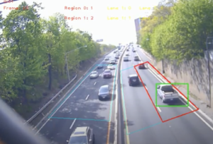
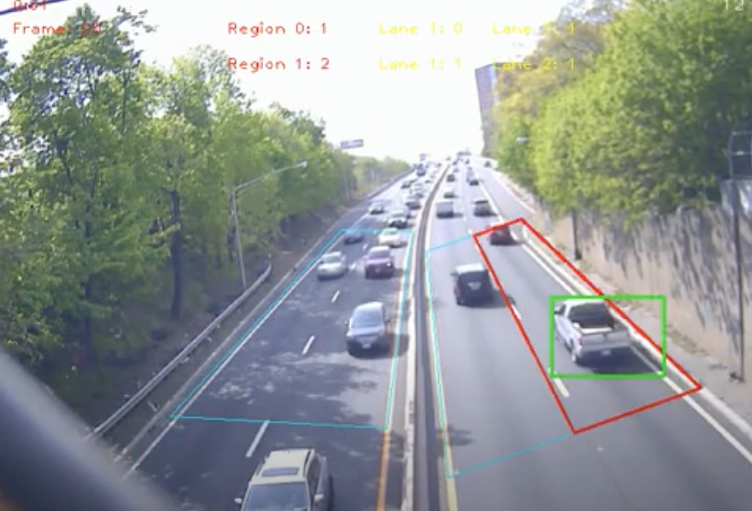
Figure 1. A video feed shows the AI identifying passing vehicles on I-280 in real-time. Courtesy of Innovative AI Technologies.

To test this technology, Dr. Liu’s team developed prototypes to monitor traffic in a real-world setting. The prototype consists of Video Analytics (VA)  software, and Edge Computing (EC) components. EC is a computing strategy that seeks to reduce data transmission and response times by distributing computational units, often in the field. In this case, VA and EC systems, consisting of a wired camera with a small computer attached, were placed to overlook segments of both Martin Luther King Jr. Boulevard and I-280 in Newark. Footage shows the device detecting passing cars, counting and classifying vehicles as they enter a designated zone. Existing automated technologies for traffic counting had something in the realm of a 20 to 30 percent error rate, while Dr. Liu reported error rates between 2 and 5 percent.

Additional real-time roadway footage from NJDOT shows several instances of the device flagging aberrant vehicular behavior. On I-280, the system flags a black car stopped on the shoulder with a red box. On another stretch of highway, a car that has turned left on a one-way is identified and demarcated. The same technology, being used for traffic monitoring video in Korea, immediately locates and highlights a white car that careens into a barrier and flips. Similar examples are given for congestion and pedestrians.

“This can be used for accident detection, and traffic vehicle classification, where incidents are detected automatically and in real time. This can be used in various illumination conditions like nighttime, or weather conditions like snowing, raining, and so forth.” Dr. Liu said.

According to Dr. Liu, video monitoring at NJDOT is being outsourced, and it might take days, or even weeks, to review and receive data. Staff monitor operations via video monitors from NJDOT facilities, where, due to human capacity constraints, some incidents and abnormal driving behavior go unnoticed. Like many tools using computer vision, the STVA system can provide live metrics, allowing for more effective monitoring than is humanly possible and accelerating emergency responder dispatch times.

STVA, by automating some manned tasks, would change workplace needs in a transportation agency. Rather than requiring people to closely monitor traffic and then make decisions, use of this new technology would require staff capable of working with the software, troubleshooting its performance, and interpreting the data provided for safety, engineering, and planning decisions.

Dr. Liu was keen to see his technology in use, expressing how the private sector was already deploying it in a variety of contexts. In his view, it was imperative that STVA be implemented to improve traffic monitoring operations. “There is a potential of saving lives,” Dr. Liu said.


Safety Analysis Tool - Dr. Mohammad Jalayer, Associate Professor, Civil and Environmental Engineering, Rowan University

Dr. Mohammad Jalayer, an associate professor of civil and environmental engineering at Rowan University, has been researching the application of computer vision to improving safety at intersections. While Dr. Liu’s STVA technology might focus more heavily on real-time applications, Dr. Jalayer’s research looks to use AI-based video analytics to understand and quantify how traffic functions at certain intersections and, based on that analysis, provide data for safety changes.

Traditionally, Dr. Jalayer said, safety assessments are reactive, “meaning that we need to wait for crashes to happen. Usually, we analyze crashes for three years, or five years, and then figure out what’s going on.” Often, these crash records can be inaccurate, or incomplete. Instead, Dr. Jalayer and his team are looking to develop proactive approaches. “Rather than just waiting for a crash, we wanted to do an advanced analysis to make sure that we prevent the crashes.”

Because 40 percent of traffic incidents occur at intersections, many of them high-profile crashes, the researchers chose to focus on intersection safety. For this, they developed the Safety Analysis Tool.

Image of an intersection with overlays of different colors, showing vehicle paths as they drive past, demonstrating different travel paths

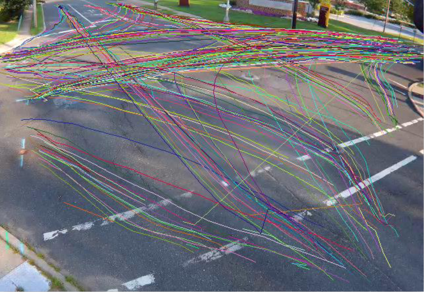
Figure 2. The Surrogate Safety Analysis in action, using user behavior to determine recurring hazards at intersections. Courtesy of Dr. Jalayer.

The Surrogate Safety Measure analyzes conflicts and near-misses. The implementation of a tool like the Surrogate Safety Measure will help staff to make more informed safety decisions for the state’s intersections. The AI-based tool uses a deep learning algorithm to look at many different factors: left-turn lanes, traffic direction, traffic count, vehicle type, and can differentiate and count pedestrians and bicycles as well.

The Safety Analysis Tool’s Surrogate Safety Measure contains two important indicators: Time To Collision (TTC), and Post-Encroachment Time (PET). These are measures of how long it would take two road users to collide, unless further action is taken (TTC), and the amount of time between vehicles crossing the same point (PET), which is also an effective indicator of high-conflict areas.

In practice, these metrics would register, for example, a series of red-light violations, or people repeatedly crossing the street when they should not. Over time, particularly hazardous areas of intersections can be identified, even if an incident has not yet occurred. According to Dr. Jalayer, FHWA and other traffic safety stakeholders have already begun to integrate TTC and PET into their safety analysis toolsets.

Additionally, the AI-based tool can log data that is currently unavailable for roadways. For example, it can generate accurate traffic volume reports, which, Dr. Jalayer said, are often difficult to find. As bicycle and pedestrian data is typically not available, data gathered from this tool would significantly improve the level of knowledge about user behavior for an intersection, allowing for more effective treatments..

In practice, after the Safety Analysis Tool is applied, DOT stakeholders can decide which treatment to implement. For example, Jalayer said, if the analysis finds a lot of conflict with left turns at the intersection, then perhaps the road geometry could be changed. In the case of right-turn conflicts, a treatment could look at eliminating right turns on red. Then, Jalayer said, there are longer-term strategies, such as public education campaigns.

Image of Safety Analysis Tool interactive box with parts that read Analysis and Video, with Results, such as Vehicle Red Light Violation

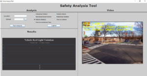
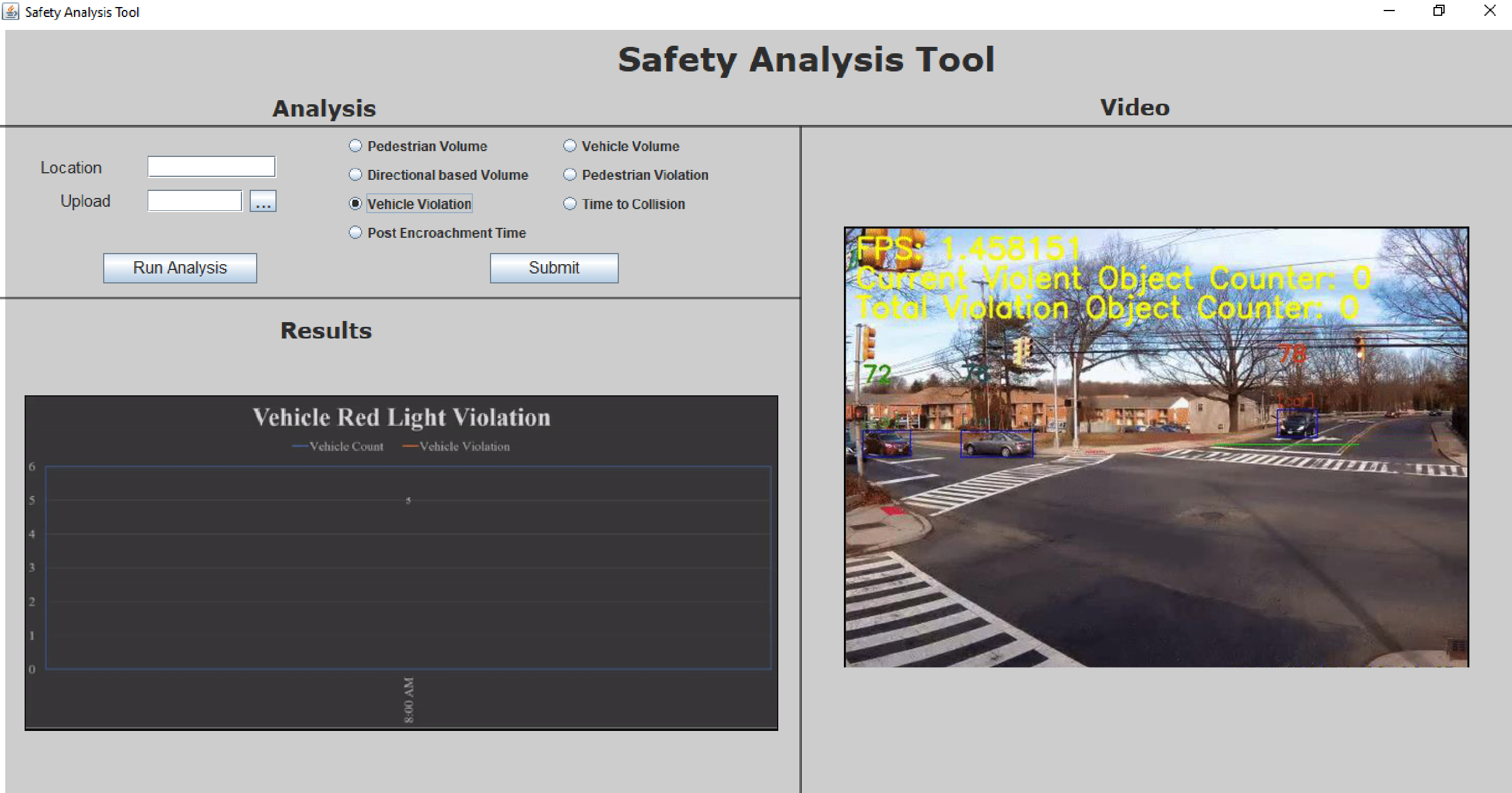
Figure 3. The Safety Analysis tool user interface, which can run various analyses of traffic video, such as vehicle violations, or pedestrian volume. Courtesy of Dr. Jalayer.

For the first phase of the project, the researchers deployed their technology at two intersections in East Rutherford, near the American Dream Mall. For the current second phase, they are collecting data at ten intersections across the state, including locations near Rowan and Rutgers universities.

Currently, this type of traffic safety analysis is handled in a personnel-intensive way, with a human physically present studying an intersection. But with the Surrogate Safety tool, the process will become much more efficient and comprehensive. The data collected  will be less subject to human error, as it is not presently possible for staff to perfectly monitor every camera feed at all times of day.

This technology circumvents the need for additional staff, removing the need for in-person field visits or footage monitoring. Instead of staff with the advanced technical expertise to analyze an intersection’s safety in the field, state agencies will require personnel proficient in maintaining the automated equipment.

Many state traffic intersections are already equipped with cameras, but the data is not currently being analyzed using computer vision methods. With much of the infrastructure already present, Dr. Jalayer said that the next step would be to feed this video data into their software for analysis. There are private companies already using similar computer-vision based tools. “I believe this is a very emerging technology, and you're seeing more and more within the U.S.,” Dr. Jalayer said. He expects the tool to be launched by early 2022. The structure itself is already built, but the user interface is still under development. “We are almost there.” Dr. Jalayer said.


AI-Based Video Analytics for Railroad Safety – Asim Zaman, PE, Project Engineer, Artificial Intelligence / Machine Learning and Transportation research, Rutgers University

Asim Zaman, a project engineer at Rutgers, shared information on an ongoing research project examining the use of computer analytics for the purpose of improving safety on and around railways. The rail safety research is led by Dr. Xiang Liu, a professor of civil and environmental engineering at Rutgers Engineering School, and involves training AI to detect  trespassers on the tracks, a persistent problem that often results in loss of life and serious service disruptions. “Ninety percent of all the deaths in the railroad industry come from trespassing or happen at grade crossings,” Zaman said.

The genesis of the project came from Dr. Liu hypothesizing that, “There's probably events that happen that we don't see, and there's nothing recorded about, but they might tell the full story.” Thus, the research team began to inquire into how computer vision analysis might inform targeted interventions that improve railway safety.

Figure showing three vehicles driving over railroad tracks, with color overlays showing that they are detected by the AI

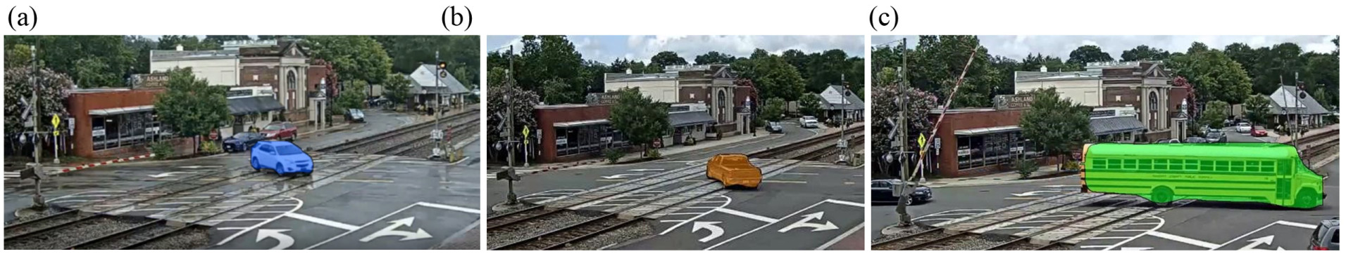
Figure 4. The color overlay of vehicles trespassing on railways demonstrates that the AI has successfully detected them. Courtesy of Zaman, Ren, and Liu.

Initially, the researchers gathered some sample video, a few days' worth of footage along railroad tracks, and analyzed it using simple artificial intelligence methods to identify “near-miss events,” where people were present on the tracks as a train approached, but managed to avoid being struck. Data on near-misses such as these are not presently recorded, leading to a lack of comprehensive information on trespassing behavior.

After publishing a paper on their research, the team looked into integrating deep learning neural networks into  the analysis, which can identify different types of objects. With this technology, they again looked at trespassers, using two weeks of footage this time. This study was effective, but still computationally-intensive. For their next project, with funding from the Federal Railroad Administration (FRA), they looked at the efficacy of applying a new algorithm, YOLO (You Only Look Once), to generate a trespassing database.

The algorithm has been fed live video from four locations over the past year, beginning on January 1, 2021, and concluding on December 31. Zaman noted that, with the AI’s analysis and the copious amounts of data, the research can begin to ask more granular questions such as, “How many trespasses can we expect on a Monday in winter? Or, what time of day is the worst for this particular location? Or, do truck drivers trespass more?”

Image of computer vision tool detecting pedestrians on tracks as train is actively using intersection, they are shown highlighted in green

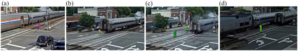
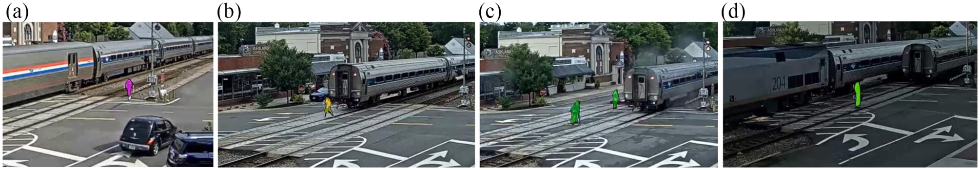
Figure 5. Similar work shows AI identifying and flagging pedestrian trespassers. The researchers are currently working on using unreported “near-miss” data to improve safety. Courtesy of Zaman, Ren, and Liu.

After the year’s research has concluded, the researchers will study the data and look for applications. Without the AI integration, however, such study would be time-consuming and impractical. The applications fall under the “3E” categories: engineering, education, and enforcement. For example, if the analysis finds that trespassing tends to happen at a particular location at 5pm, then that might be when law enforcement are deployed to that area. If many near-misses are happening around high school graduation, then targeted education and enforcement would be warranted during this time. But without this analysis, no measures would be taken, as near-misses are not logged.

Currently, this type of technology is in the research stage. “We're kind of in the transition between the proof of concept and the deployment here,” Zaman said. The researchers are focused on proving its effectiveness, with the goal of enabling railroads and transit agencies to use these technologies to study particularly problematic areas, and determine if treatments are working or if additional measures are warranted. “It's already contributing, in a very small way, to safety decision making.”

Zaman said that the team at Rutgers was very interested in sharing this technology, and its potential applications, with others. In his estimation, these computer analytics are about five years from a more widespread rollout. He notes that this technology would be greatly beneficial as a part of transportation monitoring, as “AI can make use out of all this data that’s just kind of sitting there or getting rinsed every 30 days.”

Applying computer vision to existing video surveillance will help to address significant safety issues that have persistently affected the rail industry. The AI-driven safety analysis will identify key traits of trespassing that have been previously undetected, assisting decision makers in applying an appropriate response. As with other smart video analytics technologies, the benefit, lies in the enhanced ability to make informed decisions that save lives and keep the system moving.


Current and Future Research

The Transportation Research Board’s TRID Database provides recent examples of how automated video analytics are being explored in a wider context. For example, in North Dakota, an in-progress project, sponsored by the University of Utah, is studying the use of computer vision to automate the work of assessing rural roadway safety. In Texas, researchers at the University of Texas used existing intersection cameras to analyze pedestrian behavior, publishing two papers on their findings.

The TRID database also contains other recent research contributions to this emerging field. The article, “Assessing Bikeability with Street View Imagery and Computer Vision(2021) presents a hybrid model for assessing safety, applying computer vision to street view imagery, in addition to site visits. The article, "Detection of Motorcycles in Urban Traffic Using Video Analysis: A Review" (2021), considers how automatic video processing algorithms can increase safety for motorcyclists.

Finally, the National Cooperative Highway Research Program (NCHRP) has plans to undertake a research project, Leveraging Artificial Intelligence and Big Data to Enhance Safety Analysis once a contractor has been selected. This study will develop processes for data collection, as well as analysis algorithms, and create guidance for managing data. Ultimately, this work will help to standardize and advance the adoption of AI and machine learning in the transportation industry.

The NCHRP Program has also funded workforce development studies to better prepare transportation agencies for adapting to this rapidly changing landscape for transportation systems operations and management.  In 2012, the NCHRP  publication, Attracting, Recruiting, and Retaining Skilled Staff for Transportation System Operations and Management, identified the growing need for transportation agencies to create pipelines for system operations and management (SOM) staff, develop the existing workforce with revamped trainings, and increase awareness of the field’s importance for  leadership and the public.  In 2019, the Transportation Systems Management and Operations (TSMO) Workforce Guidebook further detailed specific job positions required for a robust TSMO program.  The report considered the knowledge, skills, and abilities required for these job positions and tailored recommendations to hiring each position. The report compiled information on training and professional development, including specific training providers and courses nationwide.


Conclusion

Following a brief scan of current literature and Interviews with three NJ-based researchers, it is clear that computer vision is a broadly applicable technology for the transportation sector, and that its implementation is imminent. It will transform aspects of both operations monitoring, and safety analysis work, as AI can monitor and analyze traffic video far more efficiently and effectively than human staff. Workplace roles, the researchers said, will shift to supporting the technology’s hardware in the field, as well as managing the software components.  Traffic operations monitoring might transition to interpreting and acting on incidents that the Smart Traffic Video Analytics flags. Engineers, tasked with analyzing traffic safety and determining the most effective treatments, will be informed by more expansive data on aspects such as driver behavior and conflict areas than available using more traditional methods.

The adoption of computer vision in the transportation sector will help to make our roads, intersections, and railways safer. It will help transportation professionals to better understand the conditions of facilities they monitor, providing invaluable insight for how to make them safer, and more efficient for all users. Most importantly, these additional metrics will provide ways of seeing how people behave within our transportation network, often in-real time, enabling data-driven interventions that will save lives.

State, regional and local transportation agencies will need to recruit and retain staff with the right knowledge, skills and abilities to capture the safety and operations benefits and navigate the challenges of adopting new technologies in making this transition.


Resources

Center for Transportation Research. (2020). Video Data Analytics for Safer and More Efficient Mobility. Center for Transportation Research. https://ctr.utexas.edu/wp-content/uploads/151.pdf

City of Bellevue, Washington. (2021). Accelerating Vision Zero with Advanced Video Analytics: Video-Based Network-Wide Conflict and Speed Analysis. National Operations Center of Excellence. https://transops.s3.amazonaws.com/uploaded_files/City%20of%20Bellevue%2C%20WA%20-%20Conflict%20and%20Speed%20Analysis%20-%20NOCoE%20Case%20Study.pdf

Espinosa, J., Velastín, S., and Branch, J. (2021). "Detection of Motorcycles in Urban Traffic Using Video Analysis: A Review," in IEEE Transactions on Intelligent Transportation Systems, Vol. 22, No. 10, pp. 6115-6130, Oct. 2021. https://ieeexplore.ieee.org/document/9112620

Ito, Koichi, and Biljecki, Filip. (2021). “Assessing Bikeability with Street View Imagery and Computer Vision.Transportation Research Part C: Emerging Technologies.  Volume 132, November 2021, 103371. https://doi.org/10.1016/j.trc.2021.103371

Jalayer, Mohammad, and Patel, Deep. (2020). Automated Analysis of Surrogate Safety Measures and Non-compliance Behavior of Road Users at Intersections. Rowan University. https://www.njdottechtransfer.net/wp-content/uploads/2020/11/Patel-Jalayer-with-video.pdf

Liu, Chengjun (2021). Stopped Vehicle Detection. New Jersey Institute of Technology. https://web.njit.edu/~cliu/NJDOT/DEMOS.html

Liu, X., Baozhang, R., and Zaman, A. (2019). Artificial Intelligence-Aided Automated Detection of Railroad Trespassing. Transportation Research Record: Journal of the Transportation Research Board. https://doi.org/10.1177%2F0361198119846468

Cronin, B., Anderson, L., Fien-Helfman, D., Cronin, C., Cook, A., Lodato, M., & Venner, M. (2012). Attracting, Recruiting, and Retaining Skilled Staff for Transportation System Operations and Management. National Cooperative Research Program (No. Project 20-86). http://nap.edu/14603

Pustokhina, I., Putsokhin, D., Vaiyapuri, T., Gupta, D., Kumar, S., and Shankar, K. (2021). An Automated Deep Learning Based Anomaly Detection in Pedestrian Walkways for Vulnerable Road Users Safety. Safety Science. https://doi.org/10.1016/j.ssci.2021.105356

Szymkowski, T,. Ivey, S., Lopez, A., Noyes, P., Kehoe, N., Redden, C. (2019). Transportation Systems Management and Operations (TSMO) Workforce Guidebook: Final Guidebook. https://transportationops.org/tools/tsmo-workforce-guidebook.

Shi, Hang and Liu, Chengjun. (2020). A New Cast Shadow Detection Method for Traffic Surveillance Video Analysis Using Color and Statistical Modeling. Image and Vision Computing. https://doi.org/10.1016/j.imavis.2019.103863

Upper Great Plains Transportation Institute. (2021). Intelligent Safety Assessment of Rural Roadways Using Automated Image and Video Analysis (Active). University of Utah. https://www.mountain-plains.org/research/details.php?id=566

Zhang, Z., Liu, X., and Zaman, A. (2018). Video Analytics for Railroad Safety Research: An Artificial Intelligence Approach. Transportation Research Record: Journal of the Transportation Research Board. https://doi.org/10.1177%2F0361198118792751

Zhang, T. Guo, M., and Jin, P. (2020). Longitudinal-Scanline-Based Arterial Traffic Video Analytics with Coordinate Transformation Assisted by 3D Infrastructure Data. Transportation Research Record: Journal of the Transportation Research Board. https://doi.org/10.1177%2F0361198120971257