
The Drone program within the Division of Multimodal’s Bureau of Aeronautics has begun to take shape as staff, funding, and a multitude of innovative ideas have come together. So what does it take to start a new and innovative NJDOT Drone program when it has never been done before? First, it starts with knowledgeable staff. A UAS (Unmanned Aerial Systems) Coordinator position was created within the Bureau of Aeronautics to lead NJDOT’s UAS initiatives. The UAS Coordinator’s role is to:
- Provide leadership, guidance, and coordination for flight operations to Divisions
- Ensure compliance with State and Federal Aviation Regulations
- Ensure flight operations are based on the most current best practices
- Coordinate FAA Airspace Waivers and ATC Authorizations
- Develop Implementation and Staff Training Plans
- Assist with the drafting of RFP’s for consultants
- Keep NJDOT informed of public perception and liability
Captain Glenn Stott is the current UAS Coordinator for the NJDOT. He is a retired Canadian Air Force jet instructor, Test Pilot, and Flight Commander. Glenn is an FAA designated examiner and authorized to grant the highest level of pilot license. In addition to his aviation experience, Glenn’s understanding of emerging technologies earned him part-time positions as an Adjunct Technology Professor for both Kean and Seton Hall Universities. Glenn’s UAS background started over 20 years ago with remote control helicopters. Currently, he serves on the NASAO (National Association of State Aviation Officials) UAS Committee and is a frequent speaker regarding drone technology in the transportation industry.
Funding was the next big issue in setting up a new program of this caliber. NJDOT applied for three FHWA grants and was fortunate enough to be awarded all three. These three separate grants are: FHWA Tech Transfer Deployment Funds for a UAS Peer Exchange on Best Practices, FHWA State Transportation Innovation Council (STIC) Incentive program for equipment & training, and FHWA State Planning & Research Program for Best Practices, Policies and Procedures.
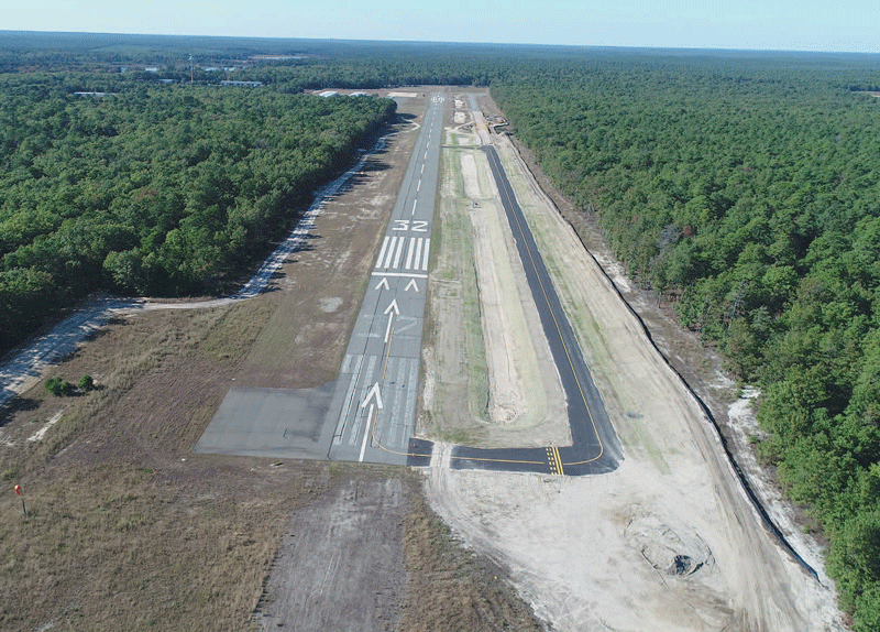
Runway 32 Taxiway construction at Eagles Nest Airport, West Creek, NJ. Photographed by Glenn Stott via drone
There are numerous potential areas for public use in transportation where UAS technology makes sense that many New Jerseyans may not be aware of. Some of the initiatives being explored are:
- Traffic Incident Management
- Structural Inspections
- Traffic Congestion Assessment
- Aerial 3D Corridor Mapping
- 3D Reality Modeling from Photogrammetry
- Emergency Response Assessment
- Real-time Construction Project Management
- Landfill volume calculations
- Inspections of confined or hazardous spaces
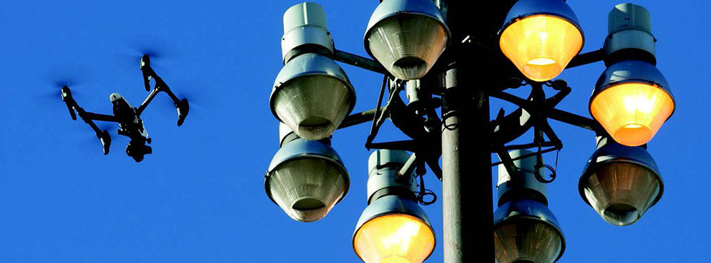
Professional UAS operations possess many advantages over traditional methods for daily operations. Some of these advantages include a relatively low cost compared to the manpower, time and equipment traditionally used, rapid deployment, a very low carbon footprint, and the ability to operate in areas that are risky or dangerous to humans. For example, NJDOT owns and operates 250 High Mast Light Poles (HMLP) near NJ roadways. HMLPs are approximately 100-feet high, and are traditionally inspected with either binoculars or bucket trucks. While there is an inherent safety risk in performing inspections so high up near a busy roadway, UAS can alleviate this risk by providing upclose inspection of HMLPs. In addition to the safety advantage, UAS provide a higher quality inspection with closer views, higher definition photos, and with less disruption to traffic as the need for a lane closure is eliminated. To date, 241 out of 250 NJDOT HMLP inspections have been successfully completed with UAS, and photo logs have been created to identify and track problem areas. UAS structural inspection does not replace the human inspector, it is simply a tool used by the inspection team to identify potential problem areas that require closer examination.
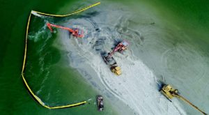
Dredging project in Brigantine, Atlantic County. Photographed by Glenn Stott via drone
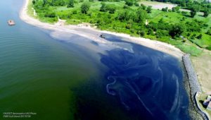
Beach Replenishment in Manasquan, NJ. Photographed by Glenn Stott via drone
NJDOT UAS projects are selected and pursued based on the opportunity to increase safety, increase efficiency, save money, and save time. Projects at this time range from collecting aerial photos over marshlands that cannot be traversed on foot, to aerial photos and videos of dredging projects at all stages in order to view the direction of the tide as well as the shoals and shallows. Drones are also being used to create 3D models that offer representation of a site and surface elevation. For example, a drone has been used to map a section of Route 26 to evaluate the potential of creating 3D maps for surface surveys. Areas are still being surveyed by hand in order to evaluate the accuracy of the drone survey elevations and calibrate the systems. 3D “Reality Modeling” with Photogrammetry provides real-world models for conceptual design, construction, and operational decisions, using simple photography rather than expensive LIDAR. 3D models created using drone Photogrammetry can be assessed and shared in CAD or GIS. The Association for Unmanned Vehicle Systems International (AUVSI) released their 2017 Economic Impact Report that estimates in the first 3 years of integration more than 70,000 jobs and 13.6$ billion economic growth for the United States. By 2025 they estimate 100,000 jobs created and an economic impact of $82 billion. As you can see, the possibilities for the use of UAS are numerous and innovative. The Bureau of Aeronautics looks forward to pursuing projects that enhance safety, efficiency, and cost-effectiveness for NJDOT in a variety of areas.