The Delaware Valley Regional Planning Commission (DVRPC) is advancing the development of bike-friendly infrastructure in coordination with road resurfacing projects in the Pennsylvania portion of the agency’s region. DVRPC is a metropolitan planning organization that includes nine counties in two states: Bucks, Chester, Delaware, Montgomery, and Philadelphia in Pennsylvania; and Burlington, Camden, Gloucester, and Mercer in New Jersey. Sarah Moran, Manager, DVRPC Mobility Analysis and Design, and Jesse Buerk, Manager, DVRPC Capital Project Development discussed the Bike-Friendly Resurfacing program in four Pennsylvania counties.
What is the program?
The DVRPC Bike-Friendly Resurfacing Program identifies roads for potential investment in bike-friendly improvements as part of regularly scheduled Pennsylvania DOT (PennDOT) resurfacing projects. DVRPC, PennDOT, the four suburban counties, and the Bicycle Coalition of Greater Philadelphia are working together to provide resources to local municipalities to improve the biking environment. PennDOT began the PennDOT Connects program to involve municipalities early in the planning process for state-sponsored transportation projects. The Bicycle Coalition of Greater Philadelphia is an advocacy group that works on the local level to inform municipalities about the program and connect residents with the counties and DVRPC. The Coalition also contributes information on local bicycling routes and route conditions.
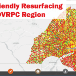
PennDOT’s five-year resurfacing program for four suburban counties (Montgomery, Delaware, Chester, and Bucks) establishes the planned repaving schedule for state-owned roads. The Bicycle Coalition of Greater Philadelphia created an interactive Google map of the paving projects for each year in the 5-Year Resurfacing Plan Map organized by county.
How does the program work?
To encourage more municipal interest in bicycle facilities, PennDOT District 6 worked with DVRPC, planners from the four southeastern Philadelphia suburban counties, and the Bicycle Coalition of Greater Philadelphia to get regional support. PennDOT, DVRPC, the counties, and the Bicycle Coalition evaluate which segments on the resurfacing schedule are good candidates for bike-friendly improvements. DVRPC then reaches out to the municipalities to tell them about the opportunities and see if they are interested. Although PennDOT pays for the design and installation of the improvements, the municipalities need to comply with the bike improvement maintenance requirements set by PennDOT. The Bicycle Coalition of Greater Philadelphia helps make the case for new bike facilities to municipal decision makers on an as-needed basis.
How are road segments prioritized?
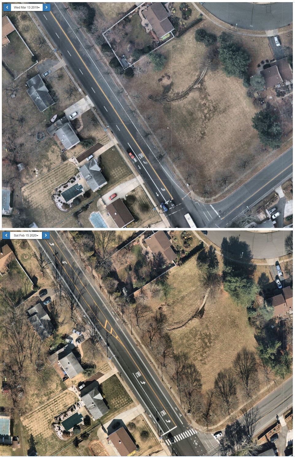
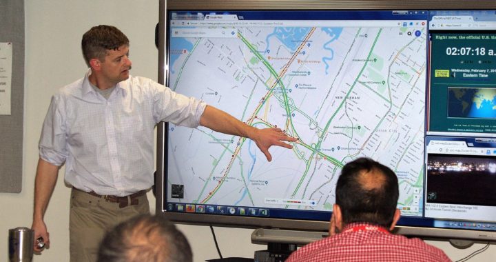
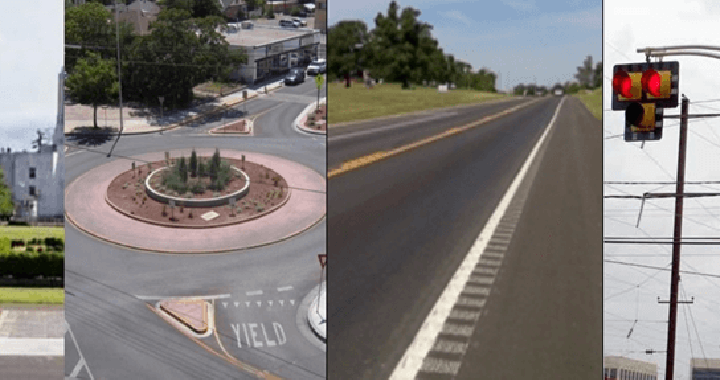
DVRPC developed an online interactive Bicycle LTS and Connectivity Analysis map. It measures both levels of traffic stress (LTS) and connectivity of road segments. LTS is a bicycle comfort index for streets and paths that was initially developed by Peter Furth at Northeastern University expressed in the Mineta Institute publication, Low-Stress Bicycling and Network Connectivity. LTS as a classification scheme ranges from 1-4. LTS 1 identifies roads that are relaxing and suitable for most riders; LTS 2 roads are comfortable for most adults; LTS 3 roads are comfortable for confident bicyclists; and LTS 4 roads are not suitable for bicycle riding. (see Figure 1) The Bike-Friendly Resurfacing Program prioritizes LTS 3 roads for improvement because they present the greatest opportunity to make them comfortable for more riders. (Figure 2 shows the web map made by DVRPC for multi-layer analysis.) The existing LTS layer classifies the road condition for the Delaware Valley Region, including the Greater Philadelphia area and four counties in New Jersey.
The connectivity analysis looked for the shortest path between any two census blocks within five miles. Improvements along the roads identified as priorities within this area would be most beneficial to build out a bicycle network by enabling the most low-stress bicycle connections(Figure 3). The bigger the role a road plays in connecting to multiple census tracts, the greater the chance it will be selected for bicycle improvements.
DVRPC is working to improve the Bicycle LTS and Connectivity Analysis by adding an equity analysis component. DVRPC considers which communities the route passes through and who lives there, based on analysis of nine indicators of potential disadvantage, such as minority populations, low-income populations, and persons with disability. Every geography is given an overall score. Areas with an above average score have a higher proportion of these traditionally disadvantaged populations and this value is assigned to routes.
DVRPC is working to build this information into the connectivity analysis in order to prioritize places with more need. DVRPC updates the Bicycle LTS and Connectivity Analysis map on a regular basis to address errors in the network, new trails, and changes in the equity analysis. Another pending improvement is consideration of slope.
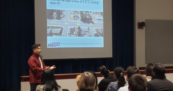
The county transportation planners review every segment scheduled to be repaved in a given year for potential connections. Every segment that is identified as a priority by any of the partners goes to the next step for more analysis related to characteristics such as road width, speed, traffic volumes. Every county has a sense of priorities, including knowledge of county and municipal plans, so this process is not limited to just a technical analysis.
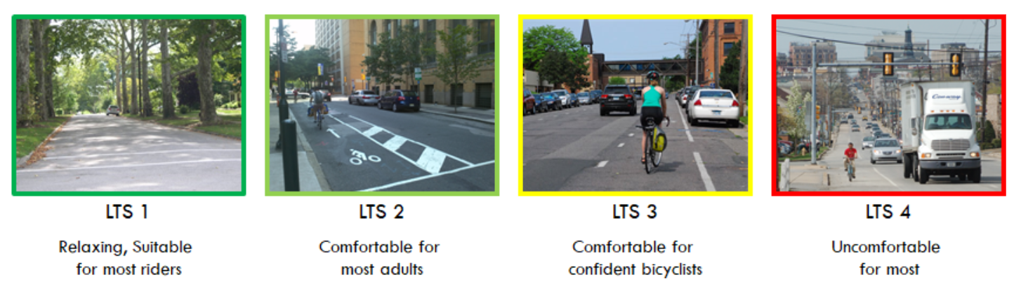
Figure 1. Levels of Traffic Stress, a bicycle rider comfort index, rates roads and paths from 1 to 4
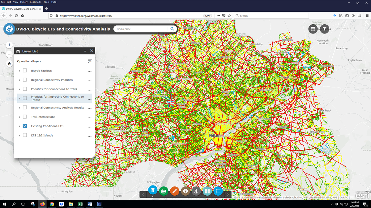
Figure 2. DVRPC map shows existing conditions map for Levels of Traffic Stress
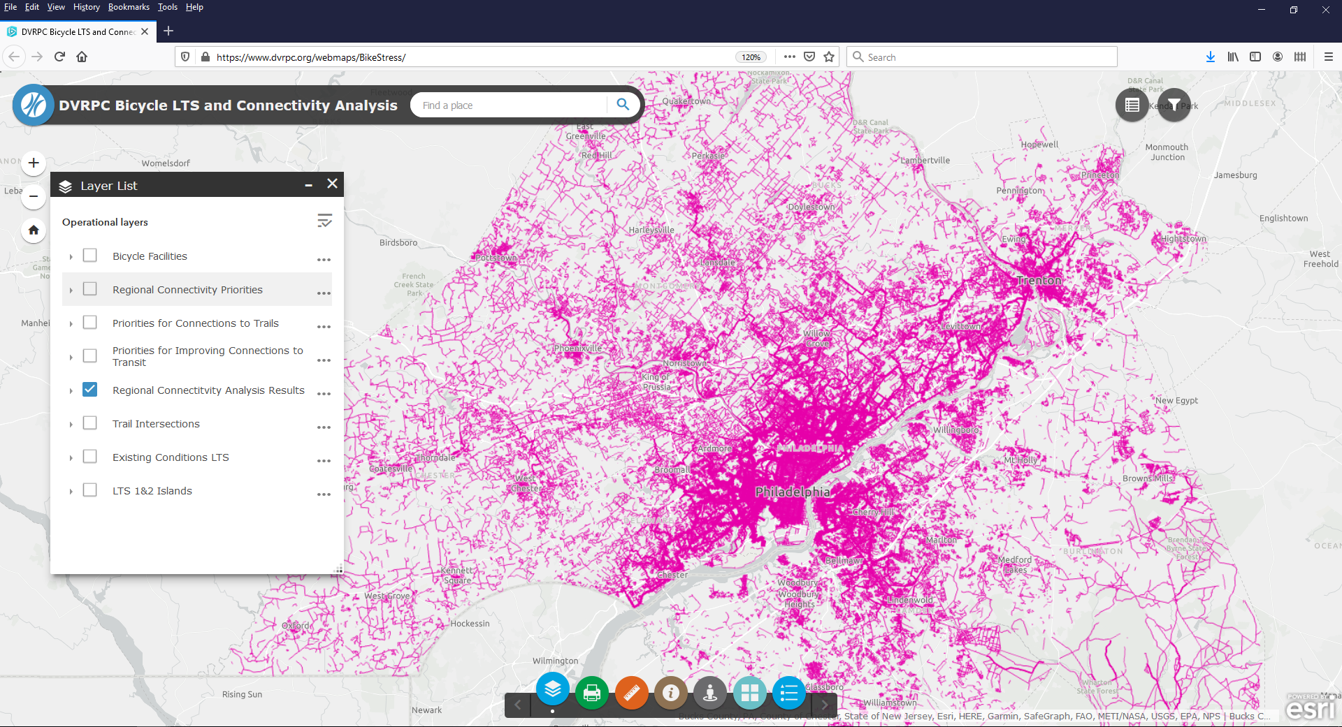
Figure 3. Regional map showing concentrations of connectivity between census blocks
When were the first projects implemented?
The first municipal projects were implemented in 2018 after an initial trial run of this program. In 2019, DVRPC started looking at all projects in relation to the five-year resurfacing plan. Currently, the process includes working one year ahead to build up a pipeline of projects for each coming year. There are many variables that affect how many projects can be completed, such as budget, weather, and shifting priorities. Municipal engagement takes time to establish and depends on local resources.
How is the program funded?
Congestion Mitigation and Air Quality (CMAQ) funds identified in the regional Transportation Improvement Plan (TIP) cover the design costs for these bicycle improvements on state highways scheduled for resurfacing. All the counties had to agree to this, even though the county of Philadelphia is not using these funds. The City of Philadelphia has a parallel program, as the City has the ability to design its own striping plans. PennDOT pays for the actual implementation of the improvements, and municipalities are responsible for the cost of maintenance.
The exact number of projects that are able to be implemented varies from year to year. DVRPC generally aims to complete two to three projects per county per year. It can be difficult to complete projects in rural areas, due to the program’s restrictions, such as being limited to the existing cartway width. However, DVRPC tries to look ahead for opportunities to even out the distribution of funding between the counties. As of now, six bike resurfacing projects have been completed and nine projects are in the pipeline.
What challenges has the program faced?
There are some challenges in getting municipalities to make the formal request to PennDOT. They have varying resources, and procedures for approval tend to be different for each community. In some cases, success comes down to finding the right contact to promote the project benefits to the community. Municipalities may lack equipment for stenciling and painting the road between resurfacings, and ongoing maintenance can be a challenge for them to take on.
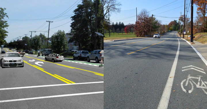
All projects are limited to what can be implemented with paint. There are road segments that are too narrow to add bike facilities but at this time, it is not possible to widen or re-crown roads through this program. DVRPC keeps a list of projects that would require larger capital investments. The hope is to find ways to address these more complicated projects with other funding sources.
Why does the program work and will it work elsewhere?
Coordination and communication are key to the success of the program. Other regions could follow the process with or without the LTS analysis. Even without the technical analysis, it would be possible to establish a simple database for tracking. DVRPC developed FAQs and other communications for municipalities, which also have general applicability. The connectivity analysis guides decision-making, but innovative technical tools only go so far. Relationship building and cooperation are needed to identify good projects and to see them through to implementation.
Note: The Pennsylvania Chapter of the American Planning Association (APA-PA) awarded DVRPC with its 2020 Award for Projects, Programs and Practices for the PennDOT Connects Bike-Friendly Resurfacing Program. This initiative combines different organizations’ planning efforts.[1]
[1] https://www.dvrpc.org/Newsletters/DVRPCNews/2020/November/
Resources
DVRPC. (2020). “APA-PA Awards DVRPC for its PennDOT Connects Bike-Friendly Resurfacing Project.” Newsletter. Retrieved at: https://www.dvrpc.org/Newsletters/DVRPCNews/2020/November/
DVRPC. (u.d.). Bike Friendly Resurfacing Program. Website. Retrieved at: https://www.dvrpc.org/Transportation/Bicycle/BikeFriendlyResurfacing/
DVRPC. (u.d.) DVRPC Bicycle LTS and Connectivity Analysis. Map. Retrieved at: https://www.dvrpc.org/webmaps/BikeStress/
Mekuria, M., Furth, P., and Nixon, H. (2012). Low-Stress Bicycling and Network Connectivity. Report. CA-MTI-12-1005. Retrieved at: https://transweb.sjsu.edu/sites/default/files/1005-low-stress-bicycling-network-connectivity.pdf