Connected Vehicles Program Pilot Testing of Technology for Safety Service Patrol Workers Continues

Video screenshot of hazard display message received

The rise of crowdsourced navigation applications and connected vehicle applications provide new opportunities to relay road service safety information to the motoring public.  NJDOT has initiated a Connected Vehicle: Road Service Safety Message pilot study that evaluates the effectiveness of using connected vehicle technology to alert the motoring public to the presence of safety service workers at an incident site. NJDOT is piloting the use of a Beacon Hazard Lights technology to alert drivers to the presence of workers when safety service vehicles turn on their hazard lights. The piloting of the technology has received the support of the NJ State Innovation Council (NJ STIC) and a STIC Incentive Funding grant of $39,600 awarded by FHWA.

The primary objective behind the initiative is to inform the public of the presence of Safety Service Patrol (SSP) personnel thru various services and applications that share real-time traffic and roadway information once they have responded to an incident or to help a motorist.  A short demonstration video of how a technology-equipped NJDOT safety service vehicle interfaces with crowdsourcing platforms in the field can be accessed here.

Periodic interim reports for the pilot study are being prepared to evaluate the technology’s application during the STIC grant period. Previously, NJDOT and New Jersey Institute of Technology (NJIT) personnel conducted a field evaluation of the technology following the device-equipped SSP vehicle then subsequently maintained a data log of the device’s activity in the field and through mobile and web-based interfaces.  In continuation of this effort, the NJIT team proceeded with a similar analysis by studying the correlation between the data recorded via the device log and the crowdsourced navigation applications web-based interface. In addition, the radio logs maintained by the Safety Service Patrol were used to further support this evaluation effort.


Professional Engineering Design Experience Program Launched at NJDOT – Provides Career Opportunities toward Licensure

NJDOT has launched the Professional Engineering Design Experience Program (PEDE) – an innovative initiative providing current NJDOT engineers with the opportunity to gain the required design experience necessary to achieve their professional engineering (PE) licensure. Engineers expressed the desire to remain with NJDOT and needed the ability to obtain a PE license to reach career goals. In launching the initiative, NJDOT recognized the need and responded to employees with the development of The Professional Engineering Design Experience Program (PEDE).

The PEDE program will offer engineering staff that have a bachelor’s degree in engineering from an accredited university, who do not currently have design responsibilities, the opportunity to work alongside a PE-licensed colleague to gain the design experience required to obtain their own PE license while remaining on the job at NJDOT. The PEDE program will build relationships between staff members as mentors and mentees who meet the program requirements as outlined in the PEDE Program Guidebook.

 width=

Mentees will have the opportunity to design projects such as: crash cushions; guiderails; pedestrian improvements such as sidewalks and ADA curb ramps; minor intersections improvements such as turn lanes, minor widening, corner cutbacks, signing and striping; sight distance issues/improvements; and minor drainage improvements through grading and re-profiling.

The program also creates leadership opportunities through mentorship. Having talented,committed leaders as mentors is critical to the success of the program. A good mentor will be a proven team player, have strong communication skills, and be a good instructor that is willing to encourage and support his or her mentee. Other requirements are outlined in the PEDE Program Guidebook. Employees can review the PEDE Program Guidebook on the NJDOT intranet.

Article adapted from the April 2019 Transporter, the NJDOT employee newsletter.


Local Safety Peer Exchanges: Summary Report

NJDOT, FHWA and NJDOT held a series of three Local Safety Peer Exchange events for municipal and county representatives to share best practices in addressing traffic safety.  These full-day events brought together representatives of NJDOT, FHWA, counties, municipalities, and Metropolitan Planning Organizations (MPOs) to discuss project prioritization, substantive safety, implementation of FHWA safety countermeasures, and use of a systemic safety approach.

The Local Safety Peer Exchanges Summary Report provides an overview of the event proceedings, including the presentations, workshop activities and key observations from the Local Safety Peer Exchanges held in December 2017, June 2018, and March 2019.

The Local Safety Peer Exchanges were funded, in part, though the use of a State Transportation Incentive Funding (STIC) grant.  The Local Safety Peer Exchange events are well-aligned with the FHWA Technology Innovation Deployment Program (TIDP) goal: “Develop and deploy new tools and techniques and practices to accelerate the adoption of innovation in all aspects of highway transportation.”  The focus of the Local Safety Peer Exchanges is also consistent with two of the FHWA's Every Day Counts (EDC-4) Innovative Initiatives: Safe Transportation for Every Person (STEP) which supports the use of cost-effective countermeasures with known safety benefits to address locations of fatal pedestrian crashes; and Data-Driven Safety Analysis (DDSA) that uses crash and roadway data to reliably determine the safety performance of projects.


On December 6, 2017 municipal and county representatives gathered to discuss best practices to address traffic safety. Topics discussed included NJ safety performance targets, use of Safety Voyager, substantive vs. nominal approaches to design, systemic vs. hot spot approaches to safety, and discussion of FHWA safety countermeasures.

The summary report provides documentation of the agenda, presentations, highlighted tools and model practices, and workshop activities for each of the Local Safety Peer Exchange events, including the December 2017 event.

EDC-4 Final Report Highlights Innovations

The EDC-4 Final Report highlights the results of round four of the Every Day Counts program to rapidly deploy proven innovations to enhance the transportation system. “Every Day Counts: An Innovation Partnership With States” documents progress in accelerating the implementation of 11 innovations in 2017 and 2018 and success stories from States across the country.  View the report’s maps and highlights to learn how innovation implementation was advanced across the country.

New Jersey’s use of “Ultra High Performance Concrete (UHPC)” for the Pulaski Skyway deck replacement in northern New Jersey is a featured “Innovation Spotlight” example in this national report.  The report highlights NJDOT’s use of precast deck panels connected with UHPC, stainless steel rebar, and a polyester concrete overlay to maximize the durability of the new deck and minimize the need for future repairs and traffic disruption.  The project is recognized as the largest user of UHPC to date in North America.  Moreover, in 2012, when NJDOT selected UHPC for the Pulaski Skyway only five other transportation agencies had used UHPC for bridge construction.  Since then, the skyway has served as an informative example for other agencies. NJDOT continues to use UHPC connections and completed five other bridges in 2018, bringing the State’s total to nine bridges.

An online version of the FHWA report is viewable here.


Local Access Management Regulations

The New Jersey Department of Transportation (NJDOT) is responsible for administering an access management policy for the state highway system.  The Federal Highway Administration (FHWA) defines access management as “the proactive management of vehicular access points to land parcels adjacent to all manner of roadways. Good access management promotes safe and efficient use of the transportation network.”

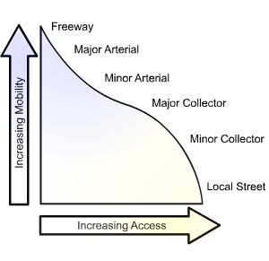
Figure 1: Conceptual Roadway Functional Hierarchy. Source: FHWA, 2017

Key components of an access management code include access spacing, driveway spacing, safe turning lanes, median treatments, and right-of-way management. While New Jersey’s access management code is highly regarded, it only applies to state highways and not local roads. Local authorities in New Jersey do not have uniform access management codes, regulations, or standards for local roads. This creates a gap in policy for how to address the issues that arise when new developments take place on local roads near intersections with state routes or when state highway improvements are required near intersections with local roads.

To address these issues, the NJDOT Bureau of Research solicited a research study of local access management regulations. The primary research objective was to identify and recommend strategies, tools, and guidelines to facilitate access management on local roads (i.e., county and municipal) intersecting and/or impacting state highways in New Jersey.

The selected research team sought to evaluate how other state DOTs address access management on local roads near state highways and explore how New Jersey local government and transportation agency officials perceive these access management issues between state and local jurisdictions

The research team carried out several tasks. First, they compiled a literature review of local access management drawing upon resources from state DOTs, the FHWA, the Transportation Research Board (TRB), local governments, among others (see Figures 1 and 2). Next, they organized and facilitated discussions with a stakeholder committee of professionals in New Jersey (e.g., municipal, county, and MPO engineers and planners) with experience addressing access management. The team conducted structured interviews with state DOTs from 13 different states, including California, Colorado, Virginia, and Pennsylvania.  NJ local government officials were reached through an online survey to gather information on current practices, issues, and relevant case studies. The researchers conducted case study analyses of specific problematic issues at intersections of local roads and state highways in New Jersey. Four site locations were selected based on the availability of data, severity of issues, geographic and land use patterns, and the relative difficulty for access management implementation based on the current system.

The interviews with other state DOTs focused on several themes, including the basis and scope of authority given under current access management laws and regulations; issues related to the development of corner lots; proactive steps taken to avoid access management issues; and recommendations for developing and implementing access. From the interviews with the state DOT officials, the research team gleaned that there is substantial variation on access management approaches. Similar to New Jersey, other State DOTs are mostly focused on

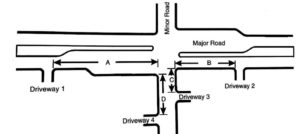
Figure 2: Diagram of Intersection Corner Clearances. Source: TRB, Access Management Manual, 2014.

state highways, although many acknowledged facing local-road issues. The team uncovered some best practice strategies that could be pertinent to New Jersey, including the development of corridor agreements between local governments and state DOTs; training local government professionals on access management; establishing communication channels between local offices of state DOTs and local governments; and funding local governments to develop their own access management guidelines and standards.

Stakeholder meetings and surveys of local New Jersey officials revealed broad support for advancing local access management guidelines. Among those surveyed, 27 percent said the local agencies that they served had formal or informal access management guidelines and 60 percent said local access management standards similar to the state highway code would be beneficial. However, key barriers were also identified, including the cost and availability of training. Local officials generally were not in favor of extending NJDOT’s authority beyond the State Highway System to county and local roads, and preferred initiatives from NJDOT to local governments that involved dedicated funding, improved coordination or dialogue, or technical assistance.

Based on the literature review and survey feedback, the research team offered for consideration to NJDOT and local governments some criteria for intersections between state highways and local roads where no local access code or guidelines are available (see Table 1).

The research team also recommended that NJDOT:

  • Develop project-specific access management criteria for intersections between state and local roads in highway improvement projects, which will work to communicate early to local agencies and property owners if they may lose parking, road access, right-of-way, etc.
  • Provide assistance via funding and training to encourage local governments to develop their own access management guidelines consistent with state code yet with more flexibility to their local roads.
  • Provide incentives for local governments to establish and apply access management policies and guidelines (using a similar approach that has been used to encourage Complete Streets policy adoption and implementation training).
  • Adopt proactive measures such as corridor agreements with local governments at corridors with highway improvement projects in the next 5 or 10 years according to the state highway improvement plan of local MPOs and NJDOT and specify the spacing criteria for intersections between state and local roads on selected corridors.
  • Establish communication channels between divisional offices of NJDOT and local governments so that all parties are aware of projects early on.
  • Continue working with the stakeholder committee established for the research study to foster dialogue between NJDOT and local governments on access management

Table 1Criteria of Access Spacing and Corner Clearance based on Posted Speed Limit

Criteria Agency Posted Speed Limit (mph)
25 30 35 40 45 50 55
Minimum Access Spacing Peer State DOTs Minimum Access Separation (feet)
NJDOT(C) 105 125 150 185 230 275 330
Peer State DOTs 125-245 125-245 125-250 245-305 245-440 440-660 440-660
AASHTO Sight Distance

280

(240*)

335

(290)

390

(335)

445

(385)

500

(430)

555

(480)

610

(530)

TRB-Manual** 330 330 330 330 660 660 880
NJ Local Agencies 150-300 200-350 250-425 300-475 350-525 400-600 400-600
Minimum Corner Clearance Minimum Distance from Corner (feet)
NJDOT(C) 50 50 100 100 100 100 100
Peer DOTs Same as Access Spacing
NJ Survey

Same as Access Spacing

Notes: (C) stands for Code/Regulations/Ordinance; (G) Stands for Guidelines/Manual/Standards; * for right-turn-only access points with median blockage; ** TRB Access Management Manual.

The research team also suggested some future work items to further advance implementation. Notably, the development of semi-automated screening tools and GIS overlays could assist in the identification of problematic locations based on state or local intersection spacing criteria. This could help expedite the design process and facilitate proactive communications and problem solving between NJDOT and local governments. Additionally, NJDOT could establish a co-training program for their related departments and local agencies to deliver needed training on general knowledge, prevailing standards and design concepts, institutional procedures, and real-world practice on past state and local access management projects. Based on this report, there is clear evidence of strong support across local and state officials as NJDOT looks to implement these recommendations and further study how to improve current practices.

Sources:
FHWA. “What Is Access Management?” February 15, 2017. https://ops.fhwa.dot.gov/access_mgmt/what_is_accsmgmt.htm

Jin, Peter J., Devajyoti Deka, and Mohammad Jalayer. “Local Access Management Regulations – Technical Brief.” 2019. FHWA-NJ-2018-003 TB

Jin, Peter J., Devajyoti Deka, and Mohammad Jalayer. “Local Access Management Regulations – Final Report.” 2019. FHWA-NJ-2018-003

Williams, Kristine M., Vergil G. Stover, Karen K. Dixon, and Philip Demosthenes. Access management manual. 2014. https://trid.trb.org/view/1341995

NJ STIC 2019 Spring Meeting

The NJ State Transportation Innovation Council recently held its 2019 Spring Meeting.  After the welcome and introductions, the FHWA provided a brief update of the status of Every Day Counts (EDC-5) Innovative Initiatives, noting that progress reports are quickly approaching for the initial six-month milestone period (January-June, 2019).

Short presentations were given by the three Core Innovation Area (CIA) Teams -- Safety, Mobility & Operations, and Infrastructure Preservation -- reporting on the activities planned and underway to meet commitments for the current EDC-5 round.  The Mobility & Operations CIA Team gave a featured presentation on "Automated Traffic Signal Performance Measures (ATSPMs)" that described current research in-progress that seeks to identify and develop metrics, guidelines, and deployment strategies for real-time monitoring of traffic signal performance based on existing infrastructure resources and the transportation agency's needs. 

The Delaware Valley Regional Planning Commission (DVRPC) and the Burlington County Engineering Office jointly delivered the featured Local Public Agency presentation on "Signal Timing in Burlington County". The presentation described a traffic signal timing optimization project funded through DVRPC that followed a six-step signal timing process.  The project used a rapid field assessment method that involved real-time coordination with traffic operations control to fine-tune signal timings to safely improve travel times.   Key findings, lessons and the benefits of the project as well as a before and after video demonstrating improved travel times were shared with those in attendance.

The Bureau of Research described recent outreach and coordination efforts being taken at the National STIC network level and by the New Jersey STIC to raise awareness of the EDC-5 Innovative Initiatives, model practices and available resources.  The NJDOT Technology Transfer website's NJ STIC Outreach and Coordination webpage has more information on these activities.   To foster knowledge-sharing, attendees were also encouraged to complete the "STIC Innovative Initiatives Survey" that was launched recently.  The survey is targeted to Local Public Agencies and seeks to identify examples of successful implementation of innovative practices, among other topics.  The meeting closed with a Roundtable discussion that highlighted the value that the NJ STIC can bring in convening and sharing innovative practices among its diverse set of stakeholders.

The next two upcoming STIC meetings are scheduled for August 8 and November 19, 2019.

The NJ STIC Spring Meeting Presentations can be found here or in sections below along with Burlington County's before and after video of their signal optimization.


Welcome; Roundtable Recap; FHWA Update

CIA Team Update: Safety

CIA Team Update: Mobility and Operations

CIA Team Update: Infrastructure Preservation

Automated Signal Timing Performance Measures

Signal Timing in Burlington County

Outreach & Coordination Efforts; STIC Survey; Roundtable

Purchase and Evaluate the Use of Tablets for Construction and Work Zone Inspection

In FY2017, the NJ STIC recommended that a STIC Incentive Funding grant be used for the purchase and the piloting of the use of the tablets for construction and work zone inspections.

Once acquired, the use of tablets were found to expedite as-built review reporting. For example, comments between team members were easier to share and compile and As-Built review reports, checklists and other supporting documents were no longer printed prior to the review. The reports and checklists could be completed electronically at the field office during the review as the information was collected.  A list of findings could be created during the review and shared electronically with the resident engineer (RE) and the review team.  Guides and manuals could also be shared with the RE on the tablets during the As-Built review to answer any questions.

Several benefits were evident from the use of the tablets in construction and work zone inspections:

  • Improved communications within a team in sharing or demonstrating a design idea such as sketches, field changes, request for information, etc.
  • Improved efficiency in keeping field records, particularly through the use of the camera’s function for capturing field videos and pictures.
  • More productive meetings as participants had the ability to quickly reference contract documents, plans or emails (Ex. progress construction meetings with contractor, Project Manager/Designer, and utilities.)

Some other lessons were noted in piloting the use of the tablets:

  • It is important to keep the battery fully charged; the battery life was found to last up to two hours with extensive use.
  • For practical use on site, the use of a stylus pen makes it much easier to use.
  • The tablet keyboard will be easier to use if a mouse device is available.
  • It is essential to have and maintain the remote internet access connection to enjoy the benefits of the field use of tablets.

Advancing Use of Mobile Devices in Administration and Oversight of Local Public Agencies Program

By adopting a paperless process for delivering construction administration documents, practitioners can save time and resources while improving the process of managing construction documents. New Jersey’s State Innovative Council recommended that a STIC Incentive Funding Grant be awarded to NJDOT to advance the use of mobile devices in the administration and oversight of its Local Aid Program.  The NJDOT received a STIC Incentive Funding Grant of $21,464 in FY2015.

The STIC grant funded the acquisition of tablets for use in two areas: application ratings and construction inspection.  The primary benefits of the transition to tablets were expected to come from improved staff efficiency through a reduction in the preparation time prior to field visits and an elimination of the need to manually transfer data collected on paper in the field.

NJDOT’S Division of Local Aid was able to use the funding to acquire 14 tablets and Mi-fi “hotspot” cards to ensure field network connectivity.  NJDOT’s IT department was engaged to coordinate the procurement process to the purchase the tablets for Local Aid staff and install cellular connection, VPN Access, security software, licensing. Electronic Field Inspection reports were designed, developed and tested in accordance with the Division’s Policy and Procedure for Construction Inspection.  District training was delivered for the use of tablets for construction inspections of federal projects. The tablets were distributed to the 4 Local Aid districts and are in use.

Making Work Zones Smarter: Data-Driven Decision Making

In honor of Work Zone Safety Awareness Week, the NJDOT Bureau of Research hosted a Lunchtime Tech Talk, “Making Work Zones Smarter: Data-Driven Decision Making” on April 11th.  Dr. Thomas M. Brennan from The College of New Jersey discussed his research using probe vehicle data – that is, anonymous vehicle speed data — to inform the development of work zone mobility performance measures and “Smart Work Zone” congestion management strategies.

Dr. Brennan described how probe vehicle data can be applied to work zone planning.

An important goal of Dr. Brennan’s research has been the development of mobility performance measures that align with the transportation agency’s goals to improve reliability and speeds and diminish delays, queuing, and user costs.   In his talk, Dr. Brennan demonstrated how probe vehicle data collected from a public agency or commercial vendor can be converted from its raw form into mobility performance measures and compelling visualizations for decision-makers to use in formulating appropriate work zone policies and procedures.

He outlined a case study design framework and the steps needed for analyzing work zone effects on mobility performance measures. He described the types of information needed to conduct a work zone mobility audit, including traffic flow and work zone activity data. Using anonymous vehicle speed data, information about traffic slowdowns within the designated area can be gathered.   With enough data points stored over time – and with the appropriate performance measures and visualizations – it is possible to evaluate whether a work zone is increasing congestion as a result of the roadway system, as a result of the type of construction being undertaken, or some combination of both.

Dr. Brennan described the research he has performed in work zones in both Indiana and New Jersey, including an example of road closures of Route 80 in New Jersey. He found that, by gathering speed data alone, one could make an informed observation on when road work was being done and the effects on the surrounding road system. The data measured the impacts of work zones before, during, and after a project’s completion, showing the total “life-cycle” effect of a work zone.

Dr. Brennan noted several types of decisions that state agencies must make to implement a data-driven approach to work zone management.   For example, state agencies will need to select the types of work zones to apply the information, determine appropriate performance measures, define appropriate criteria for “congestion” thresholds, establish the right level of geographic detail and frequency for monitoring and measuring performance, and identify strategies to manage poorly performing work zones.  High-level agency strategies must also be put in place for efficiently archiving the various data that is collected, defining appropriate agency-wide performance measures and standards, and whether to incentivize contractors based on mobility performance measures, among other considerations.

Visualization of performance thresholds for speed, delays travel times.

During the course of the talk, Dr. Brennan highlighted various ways in which probe vehicle data can be used to characterize the reliability, resiliency and congestion at the regional and granular level to inform work zone planning. He hopes to use traffic flow data and work zone activity data to develop a comprehensive guide on how best to predict future congestion. Such data would combine the type of work zone (e.g., lane closures, patching, ramp closures, etc.) with archived data showing how previous similar events had affected the road system. This information could be used to provide agencies with alternative designs for future work zones, and provide drivers with alternative routes, thereby improving the safety and capacity of a work zone for workers and travelers alike.

Resources

Brennan, T. (2019).  Making Work Zones Smarter: Data Driven Decision Making (Presentation)

Brennan, T. M., Venigalla, M. M., Hyde, A., & LaRegina, A. (2018). Performance Measures for Characterizing Regional Congestion using Aggregated Multi-Year Probe Vehicle Data. Transportation Research Record, 2672(42), 170–179. https://doi.org/10.1177/0361198118797190

Remias, S., T. Brennan, C. Day, H. Summers, E. Cox, D. Horton, and D. Bullock (2013). 2012 Indiana Mobility Report: Full Version.  https://docs.lib.purdue.edu/imr/4/