Adaptive Signal Control Technology (ASCT) is a smart traffic signal technology that adjusts timing of traffic signals to accommodate changing traffic patterns and reduce congestion. NJDOT recently deployed this technology in select corridors and required a set of metrics to gauge functionality and effectiveness in easing traffic congestion and reliability. However, the monitoring and assessment of the ASCT performance at arterial corridors has been a time-consuming process.
The Automated Traffic Signal Performance Measures system (ATSPMs) developed by Utah DOT is one of the widely-used platforms for traffic signal performance monitoring with a large suite of performance metrics. One limitation of the existing ATSPM platform is its dependency on high-resolution controllers and the need to set up hardware and software at each individual intersection. Upgrading the existing controllers and reconfiguring the hardware and software at each intersection requires significant investment of funding and labor hours.
Recently completed research funded by the New Jersey Department of Transportation’s Bureau of Research mobilized researchers from Rutgers University, The College of New Jersey (TCNJ), and Rowan University to assist in advancing the goal of establishing automated traffic signal performance measures. The goals of the needed research were to develop a prototype Automated Traffic Signal Performance Measures platform for ASCT systems. The main focus was how to take advantage of the centrally-stored signal event and detector data of ASCT systems to generate the ATSPM performance metrics without intersection-level hardware or software deployment.
The study’s primary objectives were to examine: 1) how to utilize existing field data and equipment to establish Signal Performance Measures (SPMs) for real-time monitoring; and 2) identify what additional data and equipment may be employed to generate additional SPMs while automating the real-time traffic signal monitoring process. This research is especially important for New Jersey (NJ) with the deployment of ATSPM and the establishment of NJDOT’s Arterial Management Center (AMC).
Background
At present, NJDOT maintains a traffic signal system comprised of many types of equipment that affect signal performance, including different signal configurations and vehicle detection devices. Older equipment and ineffective detection technologies make real-time traffic signal monitoring quite difficult to implement across the state. With the implementation of more centrally-controlled traffic signal systems and the Department’s Arterial Management Center (the central control for remotely monitoring these signals) coming online, NJDOT needed standards to assure that the signals would operate properly and ease traffic congestion, and that the signals could be monitored remotely in real-time effectively.
ATSPMs are promoted by FHWA (Federal Highway Administration) as an EDC-4 (Every Day Counts 4) initiative. The use of ATSPMs has important foreseeable benefits:
- Increased Safety. A shift to proactive operations and maintenance practices can improve safety by reducing the traffic congestion that results from poor and outdated signal timing.
- Targeted Maintenance. ATSPMs provide the actionable information needed to deliver high-quality service to customers, with significant cost savings to agencies.
- Improved Operations. Active monitoring of signalized intersection performance lets agencies address problems before they become complaints.
- Improved Traffic Signal Timing and Optimization Policies. Agencies are able to adjust traffic signal timing parameters based on quantitative data without requiring a robust data collection and modeling process.
Research Approach
The research team recognized that the deployment of various adaptive traffic control systems such as InSync and SCATS systems on major NJ corridors and networks improved the capability for building real-time performance measures. The study included: a review of the literature and best practices; several stakeholder meetings; and recommendations and development of performance metrics, system architectures, data management, and strategies for deploying ATSPM systems using existing and planned NJDOT arterial infrastructure and technologies.

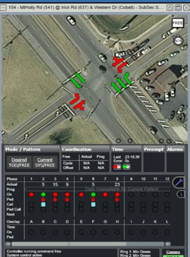
Figure 1. An Example real-time performance monitoring on County Road 541 and Irwick Road, Burlington County, NJ
The researchers first conducted a literature review to identify examples of existing Signal Performance Measurement (SPM) systems to help inform the development of ATSPMs. The researchers described several exemplary initiatives, including the following:
- In 2013, the Utah Department of Transportation’s (UDOT) SPM Platform was named an American Association of State Highway and Transportation Officials (AASHTO) Innovation Initiative. Deployed across the state, the system allows UDOT to monitor and manage signal operations for all signals maintained by the agency while aiding in more efficient travel flows along corridors.
- From 2006 to 2013, the Indiana Department of Transportation (INDOT), with Purdue University, established a testbed of signal performance measures. INDOT developed a common platform for collecting real-time signal data, which became the foundation for AASHTO’s Innovation Initiative on Signal Performance Measures. This performance system has now been deployed at more than 3,000 intersections across the country.
- Researchers at The College of New Jersey have established a signal performance measurements testbed using Burlington County’s centralized traffic signal management system. Traffic signal data collected along County Route 541 has been used to generate real-time performance measures and identify infrastructure improvements that could advance NJDOT’s ability to use real-time SPMs. An example of the existing real-time performance monitoring for Irwick Road and CR541 in Westhampton, NJ in Burlington County is shown in Figure 1.
- Many state or local agencies including Pennsylvania DOT, Michigan DOT, New Jersey DOT, Lake County (Illinois), and Maricopa County (Arizona), etc., are actively incorporating ATSPMs into their traffic management and operation strategies. Lessons learned from implementation of ATSPMs from different agencies revealed that ATSPMs are critical to ATCS.
The research team organized and facilitated targeted stakeholder meetings. These meetings confirmed that stakeholders were not currently able to perform efficient real-time post-processing of the existing available data. Through the meetings, the research team was able to scope more deeply into the type of performance measurements that were feasible and what could be done with the collected information. Stakeholders also conveyed that the total number of operating adaptive signal intersections would more than double in the near-term future, making the need to efficiently process and leverage data from adaptive systems a more pressing concern. The discussions further confirmed that the big question for study was how to best leverage these adaptive systems to evaluate and manage future corridors.
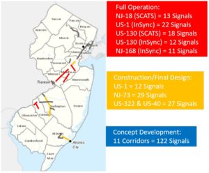
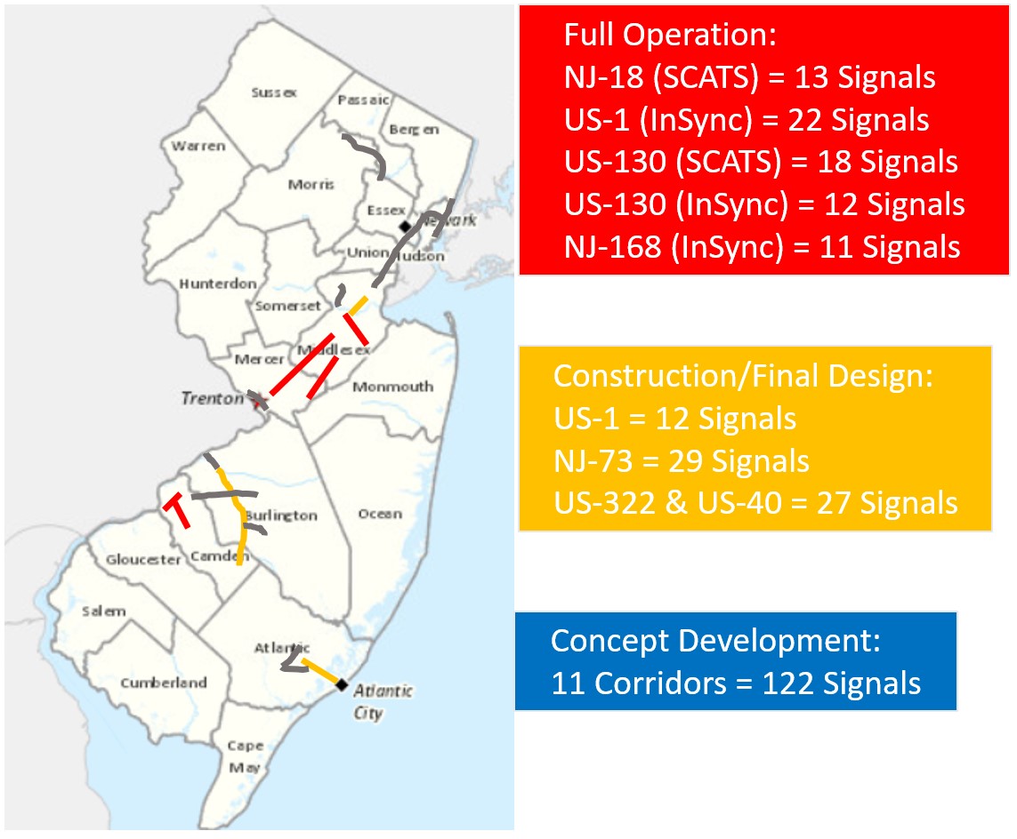
Figure 2. Corridors where NJDOT has deployed ASCT systems; red denotes full operation, yellow denotes under construction, and blue denotes concept development
The research team sought to better understand the inventory of NJDOT’s existing and planned ASCT systems. In 2019, New Jersey had over 2,500 NJDOT-maintained signals, but only 76 signals were on Adaptive Traffic Signal Systems. In addition to the existing five corridors and the district in which ASCT systems had been deployed, 3 corridors were under construction and/or in final design and another 11 corridors were in the concept development phase for future ASCT installation at the time of the study (see Figure 2).
The research team visited the state’s Arterial Management Center (AMC) and investigated several signal performance systems – specifically, the Sydney Coordinated Adaptive Traffic System (SCATS), Rhythm Engineering’s InSync, and the Transportation Operations Coordinating Committee’s (TRANSCOM) real-time data feed – to better understand their interfaces, different types of detectors and their availability.

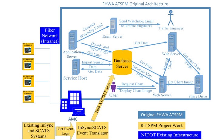
Figure 3. System Operation Data Flow Diagram
The research team designed an automated traffic signal performance measurement system (ATSPM) based on existing ATSPM open-source software to develop an economically justifiable ATSPM for arterial traffic management in New Jersey. The entire system operates as shown in Figure 3. The high-resolution controller belonging to existing infrastructure is connected to an AMC at each signalized intersection. The controller event log file contains signal state data that is sent to an AMC database. The research team’s program automatically retrieves these data logs and translates the unprocessed data into a standard event code. The converted event file is inserted into an ATSPM database and the ATSPM software can generate signal performance metrics and produce visualizations to support performance-based maintenance and operations by traffic engineers.
Key Research and Implementation Activities
The research team successfully created a bench test of the ATSPM system based on data collected from high-resolution data from adaptive signal control systems including 13 SCATS locations on NJ Route 18 and 2 InSync locations on US Route 1. As a result of the testing, the research team successfully assembled a prototype for automated traffic signal performance measures in New Jersey.
Key research activities from the project are as follows:
- Create Inventory of Existing NJDOT Arterial Management System: The team investigated several signal performance systems including InSync, SCATS, and TRANSCOM fusion application interfaces and different types of detectors and their availability. The team also conducted intensive review of state-of-the-art-and-practice of ATSPM system and identified ways of migrating the system to NJ.
- Identify Performance Metrics and Measurement Methods for NJDOT ATSPM System: The team conducted a comprehensive review of SPMs built into an ATSPM system. The team investigated and customized SPMs that can be generated by NJDOT detector and travel time data.
- Develop System Architecture and Concept of Operations for NJDOT ATSPM System and Established a Bench Test of ATSPM Located on TCNJ’s Campus: To leverage the existing ATCS system, the team developed a signal event conversion program to translate existing SCATS and InSync history log file to an event code that can be recognized by ATSPM. The detailed metrics are summarized in the figures to the right.
- Prepare Real-Time Traffic Signal Data Management Guidelines: The research team created data management guidelines and a manual for data processing. The team validated the outputs through a comprehensive process. The team also completed a test to automatically connect to an ATSPM database using a VPN and MSSQL database management system.
- Develop Deployment Strategies Considering Existing, Planned, and Future Systems/ Conduct Case Studies of System Deployment: The team initiated the pulling of one-month of data into their platform for the ATSPM. Large scale deployment of this system was expected to be conducted as part of Phase II research.
The research team observed that ATSPMs have distinct advantages over traditional traffic signal monitoring and the accompanying management process. The systems help shorten feedback loops with easier data collection and signal performance comparisons to enable before and after timing adjustments.
Future Work
In the first phase of the research project, the research team developed a software toolbox, NJDOT ATSPM 1.0. The toolbox can convert the event output data from SCATS and InSync ATSC Systems into event data that can be processed by the ATSPM platform. The primary accomplishment was to integrate ATSPMs with existing ATCS from the centralized management console, instead of configuring at each controlled intersection on field. The proposed system bridges the gap between increasingly deployed ATSC and emerging ATSPMs without investment on new controllers. The effect of this research was validated on two selected corridors. NJDOT arterial management operators are able to use the ATSPM platform to generate key performance metrics and conduct system analysis for NJDOT’s ATSC corridors.
While the initial deployment and analysis was successful, it was limited in its scope. Phase II of the research involves the development and deployment of a significantly-enhanced version of the original toolbox, NJDOT ATSPM 2.0, along with a pilot study on the integration of ATSC controllers with Connected Autonomous Vehicle (CAV) technologies.
The research team will work with NJDOT to identify and add new performance metrics to generate additional Signal Performance Measures. The team can incorporate proprietary data from traveler information providers (e.g. INRIX and HERE) to generate other performance metrics such as queue/wait time, degree of saturation, predicted volumes, etc., and incorporate them into the NJDOT ATSPM platform. The team will also conduct pilot testing on the integration of Connected and Automated Vehicle (CAV), Roadside Units (RSU), On Board Unit (OBU) with the existing and planned NJDOT ATSC systems.
This developed ATSPM system from Phase II will bridge the gap between collected traffic data (e.g., signal controller data, detector data, and historical data) and needed performance information for decision-making. Phase II research is underway with an expected completion by November 2021.
Relationship to Strategic Goals
The development of RT-SPMs and the adapting and deployment of ATSPM with existing NJ ATSC systems is aligned with the FHWA EDC (Every Day Counts) Initiative to promote the rapid deployment of proven innovations. NJDOT ATSPM 2.0 will help meet the strategic EDC goal to accelerate the deployment of ATSPMs on existing and planned arterial corridors to reduce crashes, injuries, and fatalities, optimize mobility and enhance the quality of life.
The Phase II research supports the state initiative on advancing policy and testing of CAV technologies in New Jersey. The outcome of the project will be reported to NJDOT which is part of the New Jersey Advanced Autonomous Vehicle Task Force to make recommendations on laws, regulations and guidance to safely integrate advanced autonomous vehicle testing on the State’s highways, streets, and roads.
Resources
McVeigh, Kelly. (2019). Automated Traffic Signal Performance Measures. Presentation at NJ STIC May 7th, 2019 Meeting.
Jin, P. J., Zhang, T., Brennan Jr, T. M., & Jalayer, M. (2019). Real-Time Signal Performance Measurement (RT-SPM) (No. FHWA NJ-2019-002). Retrieved at: https://www.njdottechtransfer.net/wp-content/uploads/2020/01/FHWA-NJ-2019-002.pdf
Jin, P. J., Zhang, T., Brennan Jr, T. M., & Jalayer, M. (2019). Real-Time Signal Performance Measurement (RT-SPM) – Technical Brief Retrieved at: https://www.njdottechtransfer.net/wp-content/uploads/2020/01/FHWA-NJ-2019-002-TBrev.pdf
Zhang T., Jin P., Brennan, T., McVeigh, K. and Jalayer, M, Automating the Traffic Signal Performance Measures for Adaptive Traffic Signal Control System. ITS World Congress. 2020.


 The New Jersey Department of Transportation’s (NJDOT) Bureau of Research invites you to share your ideas on the NJ Transportation Research Ideas Portal.


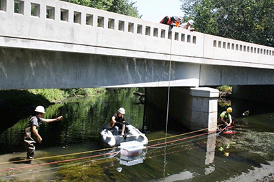
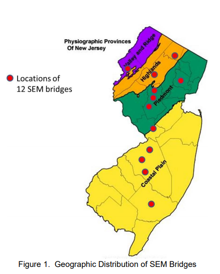 Secondly, the project evaluated 12 bridges fully using SEM with the participation of three consulting firms. Two of the bridges in the study were found to be Priority 1 (high risk), one bridge was found to be Priority 3 (medium to low risk) and nine bridges were found to be Priority 4 (low risk). The low risk bridges were then recommended for removal from the scour critical list.