WEBINAR: Traveler Information and Traffic Incident Management: Crowdsourcing Course

Since 2019, the FHWA Every Day Counts (EDC) Innovation, Crowdsourcing for Advancing Operations, has been supporting the adoption of crowdsourced data and tools to advance transportation operations across 35+ States and their local agencies to improve traffic incident, road weather, work zone, traffic signal, traveler information, and emergency management, along with a host of other ITS and TSMO practices.

The Crowdsourcing Innovation Team in collaboration with the ITS Joint Program Office (JPO) Professional Capacity Building (PCB) Program delivered this introductory Crowdsourcing course, one in series of webinars, featuring State and local practitioner perspectives.

On July 18, 2023, Sal Cowan, NJDOT’s Senior Director of Mobility served as one of the course instructors for Traveler Information and Traffic Incident Management, the third session in a webinar series targeted to transportation professionals with an interest in or responsibility for the management and operations of roadway systems. Mr. Cowan delivered instruction on how crowdsourcing can be used to enhance traveler information. He shared examples of how some leading state transportation agencies (e.g., Virginia, Arizona, Kentucky, Pennsylvania) are using various crowdsourcing platforms for communicating traveler information. Mr. Cowan then spoke at greater length about New Jersey’s Travel Information Systems, highlighting the state’s initiatives for Commercial Vehicle Notifications, 511 Platforms and Voice Assistant Systems, and Crowdsourced Data, among other topics.

Mr. Cowan was joined by two other featured speakers and the event’s host, Ralph Volpe, EDC-6 Crowdsourcing Program Co-Lead, who moderated the capacity-building webinar.

Vaishali Shah, AEM Corporation, Support Lead for the FHWA EDC-5/6 Crowdsourcing Innovation, gave an introduction to the Traffic Incident Management topic and described the components and challenges of State and local TIM systems. She shared several examples of how crowdsourced data is being used to enhance Traffic Incident Management (TIM) around the U.S..

Mr. Cowan explained the rationale for crowdsourcing to improve traveler information and shared examples of how its being used in select states, including New Jersey.
Ms. Shah explained how crowdsourcing applications were being used to enhance TIM and shared some examples of innovative state and local deployments nationally.

John Parker, Pennsylvania Turnpike Commission (PTC), Senior Traffic Operations Project Manager, then described the PTC’s Traffic Incident Management and Traveler Information initiatives. In his talk, he described various examples of data-sharing providers and partnerships, touching upon technology platforms, dashboard features, operating challenges, and new partnering opportunities being considered by the PTC and the state of Pennsylvania to enhance crowdsourcing for TIM and Traveler Information.

More information on this webinar training event can be found here, including a recording of the webinar, the presentation, transcript, and the question and answers that closed out the training event.

ITS Training and Resource Hub

The Intelligent Transportation System (ITS) Professional Capacity Building (PCB) Program and its partners offer trainings and resources to support workforce development and technical assistance for practitioners. These resources include:

  • Trainings: Classroom, web-based and blended courses
  • Webinars: Talking Transportation and Technology (T3) webinars and Talking Technology and Transportation in Education (T3e) webinars
  • Other Resources: Fact Sheets, videos, and other materials

Most of these resources are free

Schedule and Recent Recordings

Click the ITS Training and Resource Hub link to access resources for the following topics. From the site, click an icon to access the resources for that topic or access all resources.

An archive of past webinars can be accessed to elevate knowledge on many topics.

ITS Training And Resource Hub maintains training resources on these topics.

Image of an intersection at night, a long exposure has made the cars driving by appear as lines of light

Adventures in Crowdsourcing Webinar Series 

The Crowdsourcing Innovation Team in collaboration with the Intelligent Transportation Systems Joint Program Office (ITS JPO) Professional Capacity Building (PCB) Program is offering the crowdsourcing course through a series of five free webinars. Webinars feature State and local practitioner perspectives to complement course content. Webinars will take place the third Tuesday of each month at 1:00 p.m. EST.

The following highlights webinar dates and topics in 2023 (links to completed recordings of webinars and presentations may be pending)

The Crowdsourcing Course is intended for transportation operations managers, transportation analysts, consultants, and university students focusing on transportation. Because it is an introductory course, prior crowdsourcing experience is not required for participation. The course is intended to:

  • Broaden participants’ understanding of how crowdsourced data from free navigation apps, vehicle probes, connected vehicles, social media, and other sources can improve transportation operations and safety.
  • Help participants consider whether a specific application of crowdsourced data could meet their organization’s needs for improving transportation operations.

Crowdsourcing for Advancing Operations was a Federal Highway Administration’s (FHWA) Every Day Counts initiatives for the 2021-2022 round (EDC-6). The program looked for innovative solutions to integrating low-cost data, such as information from smartphones or connected vehicles, into transportation systems management and operations (TSMO). To support this effort, FHWA offers “Adventures in Crowdsourcing”, a series of virtual events with industry leaders sharing their knowledge and solutions.  More information on this EDC-6 Initiative, including case studies is available here.  

Visit the Adventures in Crowdsourcing webinar page to view past webinars, or click on one of the links below to view a specific webinar.

FHWA contacts for Crowdsourcing for Advancing Operations are James Colyar (james.colyar@dot.gov), Ralph Volpe (Ralph.Volpe@dot.gov), and Greg Jones (GregM.Jones@dot.gov), the FHWA EDC-6 crowdsourcing coleads .  

NJDOT Wins 2022 America’s Transportation Award for Best Use of Technology and Innovation

New Jersey Department of Transportation has been recognized with a 2022 America’s Transportation Award in the category of best use of technology and innovation. The annual competition is sponsored by the American Association of State Highway and Transportation Officials (AASHTO), AAA, and the U.S. Chamber of Commerce. NJDOT’s project, Implementation of Drivewyze on 647 miles of NJ’s Highways, involves the use of crowdsourced data to get more information into the hands of drivers about changing roadway conditions to inform their decision making in an effort to reduce crashes.  Commercial vehicle alerts inform truck drivers of hazards on the road, such as sudden slowdowns, disabled vehicles, debris, and adverse weather conditions, before the truck is affected by the incident. The driver can seek an alternate route or pull over until the slowdown is cleared. New Jersey’s project was highlighted in the November/December 2022 FHWA Innovator along with other State DOT winning innovations.  

For more information, go to:  

America’s Transportation Awards
https://americastransportationawards.org/new-jersey-department-of-transportation-implementation-of-drivewyze-on-647-miles-of-njs-highways/

NJ STIC Crowdsourcing for Advancing Operations
https://www.njdottechtransfer.net/2021/01/01/crowdsourcing-for-advancing-operations/

Drivewyze Dashboard. Courtesy of Drivewyze.

NJDOT’s Commercial Vehicle Alerts Initiative Featured in National Operations for Excellence Webinar

Commercial vehicle safety-related alerts can notify drivers of major slowdowns from incidents and weather to inform decision-making. Source: Sblover99, Wikimedia

The National Operations Center for Excellence held a webinar featuring New Jersey and Colorado DOT initiatives to establish private sector partnerships that use crowdsourced data to deliver real-time information to commercial vehicles to improve the safety of all road users.  Transportation agencies can now deliver in-cab alerts about road conditions through connected truck service providers to help commercial vehicle drivers approach and react more quickly to roadway incidents, work zones, and adverse weather conditions.

For this event, the NJDOT’s Senior Director for Transportation Mobility, Sal Cowan, gave a presentation, “NJDOT Using Crowdsourced Data to Improve Road Safety:  Real Time Communications with Truck Drivers”.  He was joined in making this presentation by NJDOT's private sector partners for this initiative, Amy Lopez, Director, Public Sector Services and Smart City Strategy for INRIX, and Marc Nichols, Director, Government & Industry Partnerships for Drivewyze.

As traffic deaths rise, NJDOT wants to get more information into the hands of drivers about changing roadway conditions – the earlier the better – to inform their decision making in an effort to reduce crashes.  Summoning the key phrase, “Whatever It Takes”, Director Cowan framed the life-saving imperative behind NJDOT's willingness to make greater use of crowdsourcing and real-time data tools to reduce the risk of crashes.  He highlighted how commercial vehicle alerts can inform truck drivers of hazards on the road, such as sudden slowdowns, disabled vehicles, and debris before the truck is affected by the incident. The driver can seek an alternate route or pull over until the slowdown is cleared.

INRIX collects extensive traffic data for state transportation agencies. They provide two types of alerts: "curated" incidents are from multiple sources such as DOTs, Twitter feeds, Waze, police scanners and other sources that are managed by the INRIX incident team; and "calculated" incidents such as dangerous or sudden slowdowns that are mathematically calculated by INRIX and compare real time speeds with free flow speeds at specific segment locations to identify abnormal conditions. The INRIX system has the ability to deliver real-time data that detects and describes sudden slowdowns, closures, and queues by location for specific events. This data is passed on to Drivewyze to send out alerts.

Drivewyze, introduced as North America’s largest connected truck network, provides communication with some 2.8 million trucks via its Drivewyze application which is embedded in the electronic logging device (ELD) of the truck. Drivewyze takes data from INRIX and communicates it to commercial truck drivers. The system works with severity thresholds and trigger warnings so only events that exceed these thresholds are reported. Commercial drivers receive the messages through the ELD in their cab. The reported information can be customized to include notification of specific weather events, incidents, work zones, and bridge and road closures.

A "major winter storm alert" was distributed to several states in the Northeast and reached some 4,811 trucks at a critical time.

NJDOT plays a pivotal role in providing weather and detour related data. Through this partnership NJDOT can collect extensive data regarding issues and incidents that it otherwise could not directly obtain.  This allows the state to identify areas along key highways that produce issues and NJDOT can then begin to identify ways to resolve them. In addition to analysis, NJDOT can work proactively with is partners to prevent crashes.  During Winter Storm Kenan, NJDOT was able to send alerts out through Drivewyze to thousands of trucks across the Northeast to alert drivers to a major winter storm and hazardous road conditions and to take precautions.

The webinar, part of the FHWA's Adventures in Crowdsourcing Webinar Series, had two featured presentations on initiatives to address commercial vehicle safety through crowdsourcing.  The webinar explored lessons from New Jersey, Colorado and other states through presentations and information exchange with attendees from the FHWA, other state DOTs, and private sector partners.  To learn more about the New Jersey initiative and the capabilities of its private sector partners, check out the full presentation here, starting at the 29th minute.   The presentations given by the NJ team and other presenters can be downloaded here.

National Operations Center Webinar to Feature NJDOT’s Commercial Vehicle Alerts Initiative

The National Operations Center for Excellence will hold a webinar featuring New Jersey and Colorado DOT initiatives to establish private sector partnerships that use crowdsourced data to deliver real-time information to commercial vehicles to improve the safety of all road users.  Transportation agencies can now deliver in-cab alerts about road conditions through connected truck service providers to help commercial vehicle drivers approach and react more quickly to roadway incidents, work zones, and adverse weather conditions. Follow this link to register for the Crowdsourced Data for Commercial Vehicles webinar.

At the 1st Quarter 2022 STIC meeting, attendees received a briefing about the Commercial Vehicle Alerts initiative being undertaken by NJDOT and its several partners to proactively deploy alerts to improve safety and traffic incident management. Sal Cowan, NJDOT Senior Director, Transportation Mobility, was joined by Amy Lopez, Director, Public Sector Services and Smart City Strategy for INRIX, and Marc Nichols, Director, Government & Industry Partnerships for Drivewyze.

For more information about the Commercial Vehicle Alerts initiative, their presentation is here and a summary of the NJ STIC meeting that includes a recording of their featured presentation is here.

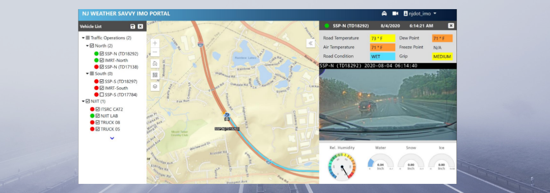
Innovation Spotlight: Testing and Deploying ITS Solutions for Safer Mobility and Operations

NJDOT’s Transportation Mobility unit is working on several initiatives related to FHWA Every Day Counts innovative initiatives, including: Crowdsourcing for Advancing Operations (EDC-4, EDC-6), Next Generation Traffic Incident Management (EDC-4, EDC-6), and Weather Responsive Management Strategies (EDC-4, EDC-5).  The unit has been creatively deploying STIC Incentive Grants and Accelerated Innovation Deployment (AID) grants to pilot test and evaluate innovations in recent years. We spoke with Sue Catlett, Project Manager in the Mobility Research Group, to provide updates on this work and discuss the coordination needed between agencies, organizations, and industry to make progress on these initiatives, and the barriers to deployment.

The Waycare crowdsourcing platform will feed information to NJDOT’s traffic operations centers to help resolve traffic issues and improve safety.

Crowdsourcing for Advancing Operations

Q.  Can you give us an update on the STIC incentive grant and the pilot of the Waycare crowdsourced data platform?

Waycare is in the DOT’s procurement process.  Once we have access to the information, the pilot will begin. We hope to see an increased situational awareness of the roadways.

Q.  Once it is deployed, will you have data coming in immediately?

We anticipate that we will have data but we will need to evaluate what that data means to us. For example, a key consideration is the definition of terms such as “crash incident,” and “accident.” We need to determine if we accept what the system’s definition of a term is or if we can set a definition.

Once the Waycare system is operating, NJDOT’s Intelligent Transportation Systems Resource Center (ITSRC), housed at New Jersey Institute of Technology (NJIT), will be working with NJDOT on the evaluation of the information coming in and matching it up with other information that DOT is utilizing.

Next Generation Traffic Incident Management

Q.  Can you update us on the deployment of the Computer Aided Dispatch (CAD) integration with the State Police?  At the 3rd Quarter STIC meeting in September 2021, you mentioned that the State Police had deployed their CAD system and are still doing some fine-tuning.

The State Police deployed their system at the end of June and are continuing to make adjustments to the system and train staff in its use. They will be building out the system by adding modules. We are working with the State Police to determine how we will have access to the information gathered and we are working towards an agreement.

Q.  Traffic Incident Management must require coordination with numerous organizations, yes?

The Department promotes the safety of traffic incident first responders through their Move Over campaign.

Yes, in fact, we just had our statewide Traffic Incident Management (TIM) meeting today where we reported out on what we have been working on, what we will be doing in the next six months, and what help we will need from others. The various participating groups also report out. TIM involves coordination with first aid, EMS, the State Police, the MPOs, municipal fire departments, the Department of Health, and many others. We have been working on the Move Over bumper sticker campaign, and the National Crash Responder Safety Week was in November, so there are a lot of initiatives that we are working on through the year with a purpose of reducing time an incident is on a roadway and keeping first responders safe while responding to an incident.

Q.  Has there been any progress on establishing an Advanced Traffic Management System (ATMS) platform or core software? What are the steps involved? What are you ultimately looking for with this platform?

In our operations centers, we gather data from many systems such as highway cameras, and travel times, as well as other information. The ATMS platform would combine these multiple platforms into one so that NJDOT operators can look in one place for all the information collected. The State Police CAD data could be included in this core software system.

We want one platform for our existing systems and we are also looking towards what we will need in the future. We worked with an engineering consultant firm to determine required elements, desired elements, and future needs. We were looking for a vendor that has a system that was already built and could then be customized to meet the Department’s needs. Any system would need to work with systems that DOT is currently using. We consulted with NJDOT Safety Service Patrol (SSP) and electrical maintenance, among others, to see what future needs they could anticipate. We wanted to cast a wide enough net to avoid missing something that other groups can anticipate now that they would need later on. We also talked to other state DOTs to receive feedback about their systems.  The pandemic slowed progress on this effort and we have not contracted with a vendor yet.

It is anticipated that the platform will be built out through the addition of modular components. This makes it difficult to predict when the platform will be ready to use.

Weather Responsive Management Systems (WRMS)

Q.  Congratulations on receiving the ITS-NJ 2021 Outstanding Project Award for the Weather Savvy Roads project. What is happening with the project?

The Weather Savvy Roads project was a collaboration with many individuals and organizations.  The project has expanded to 23, and soon to be 24, equipped vehicles. Equipped trucks include six Safety Service Patrol vehicles (3 north, 3 south) which operate 24/7, two incident management response (IMRT) trucks which can respond to incidents at any time (1 north, 1 south), and Operations vehicles including 7 snow plow vehicles (3 north, 2 central, 2 south) and pickup trucks used by supervisors who can respond where needed. We are still working on modifications and analysis of the data we have received.

Weather Savvy instrumentation displays atmospheric conditions and a dashboard view of road conditions in real time.

The Mobile Road Weather Information System (MRWIS) provides information on ambient temperature, road temperature, road condition and grip, as well as a windshield view of road conditions. Management can see what the drivers are seeing. The information helps to assess a storm’s duration and intensity while it is ongoing. The data available through the system has helped management make decisions. For example, last winter a Director referred to the system to determine how much longer crews  would need to be out on the road based on conditions, and could predict another two hours commitment.

WRMS can also assist in traffic incident management. Video of an incident, captured by an NJDOT responder truck, provides much more information than a verbal description of an incident scene. The detail can help ensure that individuals in the field can get the appropriate support and get the road back open more quickly.

NJDOT has extended the pilot deadline to June 2022 to include a second winter using the WRMS. This expansion will allow us to test the system on a potentially wider range of weather conditions, and assess the durability of the equipment. Last winter, NJIT analyzed the information we were collecting and found an issue with the data being reported. The vendor had to change their manufacturing process to address condensation issues and we installed replacement sensors.

Q.  What do you anticipate being the next steps?

We are exploring how to bring this system inside the Department. Currently, the Weather Savvy website is hosted by the ITSRC at NJIT.

Other Innovative Initiatives Underway through Research or Other Activities

Q.  Are there non-EDC innovations being undertaken at NJDOT or elsewhere in NJ that should be highlighted to STIC partners? 

Drivewyze® is a phone app that is used to inform truck drivers of upcoming weigh stations, enabling drive-by of weigh stations, and provides in-cab alerts about slowdowns or other road issues. The Department could use the system to alert truckers to specific conditions, such as truck restrictions on snow-covered roadways before they enter the State, to allow truckers to make adjustments. NJDOT is trying the system out for a year to look at the value of the information and what impact it may have.

We are also using video analytics to look at truck parking in the Harding Truck Rest Area during winter storms. Both commercial trucks and Safety Service Patrol vehicles use this rest area, and the space can become overly full and entrances and exits can be blocked. SSP vehicles need to be able to get into and out of the area to respond to incidents and for shift changes. We installed devices in the parking stalls, which provide information indicating when they are occupied, and cameras identify when trucks are parked in non-marked parking spaces. From the data collected, we hope to determine prime times for usage, and we are trying to find a way to communicate with truckers. NJIT is conducting this study through the ITSRC.


Resources

More Information on the STIC initiatives highlighted in this interview is available using the following links:

Crowdsourcing for Advancing Operations - https://www.njdottechtransfer.net/2021/01/01/crowdsourcing-for-advancing-operations/

Next Generation TIM - https://www.njdottechtransfer.net/2021/04/19/next-generation-tim/

Weather Responsive Management Strategies - https://www.njdottechtransfer.net/weather-responsive-management-strategies/

DVRPC’s Sidewalk Inventory and Crowdsourcing Platform

Improved walkability and accessibility help to create vibrant and healthy communities. The Delaware Valley Regional Planning Commission (DVRPC), the metropolitan planning organization for Greater Philadelphia and Burlington, Camden and Gloucester Counties in New Jersey, is seeking to understand the region’s pedestrian infrastructure through the development of an online inventory, map, and platform for public participation and crowdsourcing. According to DVRPC, the goal of the project is, “to assist with planning efforts to help communities in the region become more pedestrian-friendly and accessible.”

Options from the DVRPC Pedestrian Portal homepage

DVRPC hopes that these new tools will assist the agency and its partners to more efficiently identify and prioritize walkability improvements across the region. The online platform is expected to improve asset management and support various regional planning and place-specific initiatives such as Safe Routes to School, pedestrian safety audits, plans for healthy communities, and strategies for providing safe and equitable access to public transportation.

The need for better sidewalk data was suggested by DVRPC staff during a data roundtable meeting and became the impetus for the Sidewalk Inventory Project, according to DVRPC’s Kim Korejko. The MPO had already conducted work on bicycle infrastructure in the region, but lacked data on pedestrian infrastructure. The absence of a good inventory of sidewalk data was also felt by agency staff who had previously worked on transit station area walkability studies. To address this gap, DVRPC resolved to assemble a seamless and standardized GIS dataset of sidewalks in the region.

DVRPC sought state funding from both Pennsylvania and New Jersey to start the project in 2018. The planned platform for crowdsourcing and community involvement was well-aligned with “PennDOT Connects,” a Pennsylvania Department of Transportation initiative that supports collaboration with communities to sustain and expand mobility in the state. This alignment was a principal reason that the project received funding from Pennsylvania. The crowdsourcing platform also aligns well with the Federal Highway Administration EDC-5 initiative to advance crowdsourcing for operations.

Chester and Montgomery Counties in Pennsylvania had previously developed sidewalk databases, but the counties did not follow a standardized methodology for data visualization. As a result, DVRPC needed to rework the data for integration into the new dataset. Philadelphia County was also assembling sidewalk data at the time, but differences in data methodology along with the county’s scale have led to delays in assembling and publishing their inventory.

A visualization of Chester and Montgomery counties original sidewalk databases

The DVRPC sidewalk inventory is not the first of its kind in the country. TriMet, Portland, Oregon’s transit operator, undertook a pedestrian network analysis in 2011 with the goal of improving pedestrian access to transit stops, especially in the suburbs surrounding the city. Once compiled, TriMet was able to put forth 10 pedestrian access projects to improve pedestrian access to transit stops, the majority of which were bus stops, but also to light rail and commuter rail stations. TriMet is continuing its pedestrian network analysis, and is seeking public comment on transit stops with low pedestrian accessibility. DVRPC also cited Denver and Seattle’s sidewalk inventories as inspiration for the Philadelphia project.

The TriMet Pedestrian Network Analysis can be found here.

DVRPC staff were surveyed prior to the assembly of the database to explore how they would use the tool and what features they would want:

  • Sidewalk mileage and gaps — 60 percent said they would use the database to calculate sidewalk mileage and gaps to set goals and measure progress for improved network walkability.
  • Pedestrian routing and modeling — 57 percent sought to use the database for pedestrian network routing and modeling
  • Visualization — 51 percent would use it to help visualize the sidewalk data.

In terms of the data features captured by the inventory and mapping, 83 percent of staff said that they wanted to know sidewalk presence, 70 percent wanted to know the sidewalk conditions, and 59 percent wanted to know of the presence of curb ramps.

A look at the sidewalk inventory in Camden, New Jersey

Out of 30 responses, 29 staff members stated that they wanted to know the presence of crosswalks, 24 wanted to see what pedestrian signalization types are present at intersections, and 15 wanted to know the characteristics of crosswalks in the network.

DVRPC has published a sidewalk inventory, including curb ramps and crosswalks for Bucks, Chester, Delaware, and Montgomery Counties on the Pennsylvania side of their region. A sidewalk inventory for the New Jersey portion of the region was added in February 2020. Release of the Philadelphia County inventory is expected in fall 2020.

To leverage its limited capacity to maintain the database, DVRPC is seeking to crowdsource sidewalk conditions by engaging the public to help keep the map up-to-date and accurate. Community members will be able to create an account to access the editing platform to add new infrastructure and attributes to the database.

In addition, DVRPC hopes to identify and maintain a list of potential pedestrian facility projects through its Pedestrian Facilities and Planning Portal. The portal will provide a space for collaboration between local and regional planning partners working on pedestrian improvements. The secure online interface will (1) provide access to and accommodate maintenance of the regional sidewalk inventory by local entities and (2) allow local and regional planning partners to share their pedestrian facility priorities (such as those identified in their comprehensive/ master plans or those for which they seek grant funding) on an interactive map.

While the planning and editing portals are not yet active, the sidewalk, crosswalk, and curb ramp shapefiles can be downloaded through the DVRPC GIS portal for those wishing to use the inventory for analysis. Once the data has been fully assembled, DVRPC plans to undertake further analyses of pedestrian access to transit and bus stations.

The Greater Philadelphia Pedestrian Portal, which includes the currently available New Jersey and Pennsylvania inventories, can be found here.

A view of the attributes for a sidewalk in Glassboro, New Jersey

Resources:

City of Seattle. “Access Map, Walkability.” https://www.accessmap.io/.

Delaware Valley Regional Planning Commission. “The Greater Philadelphia Pedestrian Portal.” https://walk.dvrpc.org/.

Korejko, Kim. March 2018. DVRPC’s Sidewalk Inventory Project. Presentation. https://www.dvrpc.org/Walk/pdf/DVRPCSidewalkInventory_websiteMar2018.pdf.

Pennsylvania Department of Transportation. “PennDOT Connects.” https://www.penndot.gov/ProjectAndPrograms/Planning/Pages/PennDOT-Connects.aspx.

TriMet. “Improving Pedestrian Access to Transit.” https://trimet.org/walk/.

Walk Denver. June 2016. “Congratulations to the WALKscope Data Challenge Winners!” http://www.walkdenver.org/congratulations-to-the-walkscope-data-challenge-winners/

Final Report Released for the Connected Vehicles Program Pilot Testing of Technology for Distributing Road Service Safety Messages from Safety Service Patrols

NJDOT’s top priority is to improve highway safety. To support this goal, in September 2018, New Jersey began a pilot study of the effectiveness of using connected vehicle technology to alert the motoring public to the presence of safety service patrol (SSP) workers at incident sites.  With the support of the NJ State Innovation Council (NJ STIC) and a STIC Incentive Funding grant of $39,600 awarded by FHWA, NJDOT piloted the use of Beacon Hazard Lights technology on 32 safety service vehicles to alert drivers to the presence of workers via the mobile navigation app Waze. The device, which is produced by iCone, uses GPS location and wireless communication technology to transmit the location of the SSP vehicles to the iCone Data Server in the cloud where it can be picked up by Waze. Together with the New Jersey Institute of Technology’s (NJIT) ITS Resource Center, NJDOT published a final report of their findings from the pilot project in December 2019, available here.

The SSP location and message shown on the Waze.com website. Photo Source: Cowan et al., 2019.

The primary goal of the study was to test the feasibility of the iCone technology on SSP vehicles by analyzing the time elapsed between device activation and Waze notification, to examine the Verizon 4G cellular network strength for potential coverage loss that could result in service disruption in communication, and to analyze the effectiveness of the equipment through several testing means. The methods of evaluation to complete these objectives were field and remote testing of the technology and documentation of the equipment installation and repairs. Field testing was conducted from January to October 2019 by activating the iCone-enabled SSP truck hazard lights and Dynamic Message Board (DMS) at 2-mile intervals along the entire 280-mile SSP coverage area. An analyst conducted remote testing through monitoring of the iCone and Waze web-based interfaces.

The results of field testing showed that, on average, communication with Waze was successful 76 percent of the time, 20 percent of the time the device communicated with the iCone Data Server but not Waze, and the remaining 4 percent of the time the device did not transmit its location to the iCone Data Server or Waze. The average time elapsed from the iCone device activation to its appearance in Waze was 2 minutes and 41 seconds. On two days of testing along the SSP coverage area, there was no communication between the iCone device and iCone Data Server or Waze.

In addition to field testing, analysts conducted remote testing of 85 active instances of the iCone device by observing the iCone and Waze web portals. In 59 percent of these 85 instances, the active iCone device was detected in Waze, with 29 percent of these successful detections showing the exact timestamp in both Waze and iCone. These results were shared with Waze so that the company could address the issues related to missing and delayed data transmission. For equipment evaluation, results showed that by April 2019, 12 of the units had technical problems that were attributed to the winter weather conditions in New Jersey including snow, road salt, and extreme cold. The iCone engineering team was responsive to the issues and re-evaluated the device design so that replaced units could withstand the weather conditions. A prototype of the newly-designed replacement devices was delivered to NJDOT in December 2019 and has been installed in five of the vehicles.

The installation of the device on an SSP vehicle by an iCone technician. Photo Source: Cowan et al., 2019.

The researchers believe that this technology evaluation pilot project was the first of any state DOT to seek to inform the public of SSP patrol vehicle locations with the sole objective of increasing safety.  The pilot project provided valuable analysis and lessons learned to inform next steps for NJDOT. Testing and analysis of installed devices and their replacements will continue until the end of the product warranty period on September 1, 2021. Additionally, researchers recommended further investigation of the disruptions and delays in the communication path from the iCone device to Waze.  Additional coordination with each technical partner during the steps of the testing process could help to identify the cause of service disruptions.

During the study, NJIT and iCone were unable to obtain Waze data showing how many people clicked the “thumbs up” to the message on the app. Future analysis should investigate how to gather reactions of the motoring public to Waze notifications. The researchers recommended exploring partnerships with crowdsourcing GPS navigation providers to further learn how drivers are reacting, which should include a data transfer process and strategies for reducing latency between iCone data server and Waze.

The Final Report contains additional information on the purpose of the research, the role of various stakeholder organizations in the research, a description of the technology devices and tools procured and used in the research, and the evaluation results.  The Final Report was submitted to the FHWA and is available to review here.

Featured Image Source: NJDOT, 2019.

How SJTPO Refined Their Congestion Management Process with Crowdsourced Data

Through the Everyday Counts (EDC) program, FHWA identifies and deploys established but underutilized innovations through a state-based model, with the goals of streamlining project delivery, improving roadway safety, decreasing traffic congestion, and incorporating automation. The fifth round of EDC kicked off in 2019 and included Crowdsourcing for Operations as one of ten initiatives.

As described by FHWA, "When combined with traditional data, crowdsourcing helps agencies efficiently implement proactive strategies that improve incident detection, traffic signal retiming, road weather management, traveler information, and other operational programs" (EDC-5). Crowdsourced operations data can include traffic, transit, bicycle, pedestrian, construction, and weather information collected in real-time by intelligent transportation systems (ITS) infrastructure and archived for planning use. One example of this traffic data is time and vehicle location collected via GPS probe-based sources, such as vehicles and smartphones. Through NJDOT and the Metropolitan Planning Organizations (MPOs), New Jersey has institutionalized the practice by incorporating crowdsourced data into multiple operational programs since 2008.

Congestion Management Process

An example of PDA Suite's Performance Chart tool displaying archived operations data for speed. Photo source: Tracy, 2019.

The South Jersey Transportation Planning Organization (SJTPO), the MPO that represents Atlantic, Cape May, Cumberland and Salem Counties, revised its Congestion Management Process (CMP) last year, with formal adoption in November 2018. A CMP is defined by FHWA as “a systematic and regionally-accepted approach for managing congestion that provides accurate, up-to-date information on transportation system performance and assesses alternative strategies for congestion management that meet State and local needs.” Metropolitan areas larger than 200,000 people are required to develop and implement a CMP as part of their overall transportation planning process for their region.

An effective CMP will help a region pinpoint congested roadways, determine multimodal performance measures, develop congestion management strategies and implementation methods, and assess the efficacy of the implemented strategies. While FHWA does not strictly define how to implement a CMP, they do provide a CMP Guidebook with an eight-step Process Model which SJTPO followed:

  1. Develop Regional Objectives for Congestion Management
  2. Define CMP Network
  3. Develop Multimodal Performance Measures
  4. Collect Data/Monitor System Performance
  5. Analyze Congestion Problems and Needs
  6. Identify and Assess Strategies
  7. Program and Implement Strategies
  8. Evaluate Strategy Effectiveness.

Along with the 2020 Regional Transportation Plan update, two important pieces of legislation drove SJTPO’s motivation to overhaul their CMP: Moving Ahead for Progress in the 21st Century (MAP-21) of 2012 and the Fixing America’s Surface Transportation (FAST) Act of 2015. Both of these laws established requirements for performance-based planning and programming by MPOs. Performance-based planning and programming consists of the following steps: identifying a transportation system’s needs and problems, prioritizing projects and programs for investment, and monitoring impacts of the projects. SJTPO revised the CMP methodology using recently acquired real-time and archived travel time data to establish performance measures for the extent and severity of congestion throughout the region. The archived operations data provides a more holistic picture of system performance, creates more relatable and user-friendly measures, and enables more sophisticated modelling.

PDA Suite's Bottleneck Ranking tool displays here all bottlenecks found on a specific date range by time of day, visualized by maximum queue length in miles. Photo source: Tracy, 2019.

Under a contract with NJDOT, the University of Maryland Center for Advanced Transportation Technology Laboratory (CATT Lab) provided all three New Jersey MPOs with access to real-time and archived data via the Probe Data Analytics Suite (PDA Suite). The PDA Suite is a web-based platform that consists of a range of data visualization and retrieval tools for real-time and archived probe data. The vehicle probe data is provided by multiple third-party vendors, including INRIX, HERE, and TomTom, that collect it via smart phone navigation apps. These companies anonymously aggregate the data which is then used by the PDA Suite tools to calculate metrics such as real-time speed data, travel time index, travel time reliability, queue measurements, statewide bottleneck ranking, and corridor congestion charts, among others.

An overview of the tools available in the PDA Suite. Photo source: Tracy, 2019.

Agencies can use the tool to download reports, create interactive maps and graphics, and download raw data for external analysis. The performance measurement data is available at both the corridor and regional level, with 1,556 roadway segments covered in the SJTPO region. SJTPO has used PDA Suite’s Bottleneck Ranking Tool to create congestion screening lists for all of their counties; the lists are then screened for outliers and confirmed with independent data sources. SJTPO will then meet with county and municipal stakeholders to gather their input to prioritize locations and develop a problem statement. So far, SJTPO has found PDA suite valuable for quantifying seasonal congestion, which traditionally is difficult to define. Compared to traffic counts, operations data has wider spatial and temporal coverage.

Lessons Learned

While this data has been incredibly valuable to SJTPO, the agency has learned there are several drawbacks when it comes to working with crowdsourced big data. False positives may occur that identify congested areas when a roadway segment has a low sample size of probe vehicles, or there is a typical traffic signal delay or an inaccurate calculation of historical reference speed. Additionally, there are many ways to parse and analyze a dataset, which can lead to different results. To accurately represent the travel experience, organizations need to develop and use consistent methodology.

Looking forward, SJTPO plans to continually update their CMP. The document will evolve with additional insight from internal documents and studies (including the 2020 Regional Transportation Plan), changes to planning guidelines, and shifts in regional demographic and fiscal resources. In 2020, a Congestion Management Process Activity Report will be issued to summarize findings to be incorporated in the 2045 Regional Transportation Plan Update.

Sources:

CATT Lab. “Probe Data Analytics Suite.” CATT Lab. University of Maryland, 2019. https://www.cattlab.umd.edu/?portfolio=vehicle-probe-project-suite.

FHWA. “Crowdsourcing for Operations.” Center for Accelerating Innovation. U.S. Department of Transportation Federal Highway Administration, October 22, 2019. https://www.fhwa.dot.gov/innovation/everydaycounts/edc_5/crowdsourcing.cfm.

FHWA. “Congestion Management Process (CMP).” Organizing and Planning Operations. U.S. Department of Transportation Federal Highway Administration, February 11, 2019. https://ops.fhwa.dot.gov/plan4ops/focus_areas/cmp.htm.

SJTPO. “Congestion Management Process.” Congestion Management Process (CMP). South Jersey Transportation Planning Organization, 2019. https://www.sjtpo.org/CMP/.

SJTPO. “Congestion Management Process: Methodology Report.” Congestion Management Process (CMP). South Jersey Transportation Planning Organization, 2018. https://www.sjtpo.org/wp-content/uploads/2019/03/CMP-Report-2017.pdf.

Tracy, Andrew. “The Use of Real-Time and Archived Operations Data for Congestion Planning and Incident Management.” TransAction 2019. April 17, 2019. https://www.njdottechtransfer.net/wp-content/uploads/2019/11/SJTPO-TransAction-2019-Operations-Data-slides.pdf.