Tech Talk! Webinar: Crowdsourcing for Local Operations

As the technology and portability of communications have become more widespread and instantaneous, "crowdsourcing" has become an increasingly popular method for identifying and addressing problems quickly. Crowdsourcing enables an organization to distribute workloads across a large group of people, utilizing their collective wisdom and amplifying the reach of the organization. Long popular for applications such as customer reviews for shoppers and critical takes from moviegoers, crowdsourcing tools are spreading in transportation and transforming the way operating agencies work with the public.  Most often we have seen crowdsourcing used on apps like Waze for up-to-date traveler information or incident management, as these apps allow for every driver on the road to serve as the eyes and ears of the larger community.

On October 17, 2019, FHWA sponsored an innovation exchange webinar, "Crowdsourcing for Local Operations" that was “live” broadcasted by the Bureau of Research as part of its Tech Talk! series, for NJDOT staff who convened in the E&O Building, Training Room A.  The webinar illustrated how local agencies are working, often with state partners, to expand the use of crowdsourcing across a wider set of application areas.

FHWA kicked off the webinar with a brief presentation, Introduction to Crowdsourcing and Improved Transportation Operations, that provided a definition and historical context for crowdsourcing, and a summary of typical sources of crowdsourcing data and applications in transportation.  The presentation included an overview of the Every Day Counts (EDC) Program and technical assistance resources available at FHWA to support deployment of crowdsourcing.  However, the primary purpose of the event was to showcase examples from around the country where Local Public Agencies and partnering stakeholders have deployed crowdsourcing solutions for emergency management, roadway and other  maintenance, and wildlife protection.

City of Myrtle Beach uses Facebook comments, direct messages, emails, phone calls, and other tools to receive citizen input.

Crowdsourcing Using Social Media for Emergency Roadway Management, City of Myrtle Beach, South Carolina.  Mark Kruea, Public Information Director, described how the City of Myrtle Beach uses social media to help engage with residents quickly and effectively. The city takes phone calls, e-mails, and even messages and comments on Facebook on every topic, including trimming trees, fixing potholes, broken street lights, and other maintenance and needed capital improvements. The city tries to address requests within the same day which, in turn, encourages residents to use the system more frequently as they realize the city is listening and acting on suggestions. Mr. Kruea said that there was no reporting "threshold" for when a city would act on a specific comment or request, and even a single report of an issue can trigger a response.  His talk made clear the potential benefits of fostering a strong trust between the community and the municipality, particularly in planning for and managing emergency situations.  For example, during Hurricane Dorian, residents were able to send pictures of downed trees for clean-up crews to address, and adjustments were made to the storm level capacity of a regional detention pond prior to the storm event in response to community requests.

City of Richmond’s 311 portal makes it easy for citizens to report and track non-emergency service requests.

Crowdsourcing for Road Maintenance, City of Richmond, Virginia. Peter Briel, Director, Citizen Service & Response, spoke about the City of Richmond’s establishment of a 311 portal – phone, public internet portal, smartphone app -- for intake of most citizen requests for non-emergency services.  The 311 program includes a call center, a request platform, and performance reporting.  Once received, citizen requests are categorized by type and automatically routed to appropriate teams within the City’s various departments. Citizens can report a range of road issues through RVA311, including requests for new road infrastructure to report issues with maintenance, signage, traffic signals, and storm drain cleaning, among others. Citizens are able to upload photos through the app or the internet, check the status their requests, and receive push notifications when updates have been made by the city.  Mr. Briel’s presentation highlighted some of the mapping and performance management measures available in using the 311 system along with some of the organizational, technical and cultural changes required for deploying the tool for the city residents and workforce. He noted that the most challenging part of implementation of the innovation was initiating the culture change between the citizens and the city so the 311 system would not become simply an app for complaints, but instead, for citizen empowerment.

While the first few presentations dealt with infrastructure maintenance and emergency response, the next two presenters showed how crowdsourcing could be used to avoid wildlife collisions and protect their habitats.


Maine Audubon uses an online tool, Wildlife Road Watch, to identify roadkill “hot spots”.

Crowdsourcing for Wildlife Road, Maine Audubon Sarah Haggerty, a Conservation Biologist with Maine Audubon, described how her organization in association with Maine Department of Transportation and other environmental protection organizations, have worked to identify the worst areas for animal fatalities in order to prevent future accidents. Using an online tool created by the University of California-Davis Road Ecology Center, residents are able to upload photos and locations where they encounter roadkill, allowing the tool to identify hotspots around the state. In turn, municipalities can construct road-stream crossings that make it safe for wildlife passage as well as vehicular traffic, a strategy that was incentivized through extra points in state grants.


MassDOT has used historic roadway mortality data reported by citizen scientists and its maintenance personnel to prioritize and design signage, fencing, and crossings to protect wildlife endangered by traffic.

Linking Landscapes for Massachusetts Wildlife, Massachusetts Division of Fisheries and Wildlife. David Paulson, a Senior Endangered Species Environmental Specialist, described how his agency is working to incorporate habitat conservation into transportation planning and project development.  Through the use of volunteers and MassDOT maintenance personnel, historic data on wildlife roadway mortality on particular road segments have been compiled.  Citizens and workers have been asked to report locations where multiple turtles experience roadway mortality on a yearly basis, typically on roads which bisect wetlands. Concurrently, they also enlisted volunteers to help research amphibian migrations across roadways to establish documented migration routes that could be engineered around. The online tool collected data on location and roadkill numbers, giving Massachusetts a good idea of where countermeasures could be implemented.

Throughout the webinar, presentations highlighted different ways in which transportation system users and citizens can be turned into real-time sensors on system performance, providing low-cost, high-quality data on traffic operations, roadway conditions, wildlife mortality, and maintenance issues.  Using crowdsourcing as a tool to garner information met with success in each of these cases, and the resulting actions taken by state and local governments have promoted trust between users and governing agencies.  Given its wide-ranging impact and low costs to implement, FHWA surmised in closing that these and similar tools leveraging engagement would become industry standards in the future.

The Crowdsourcing for Local Operations webinar was one in a series of Innovation Exchange webinars sponsored by the Center for Local Aid Support (CLAS) in the Federal Highway Administration's Office of Innovative Program Delivery. Through Innovative Exchange webinars, CLAS seeks to bring cutting-edge transportation leaders to the table to share ideas and out of the box innovative practices that have proven results.  More information about this webinar, upcoming webinars, and webinars available on demand can be found here.

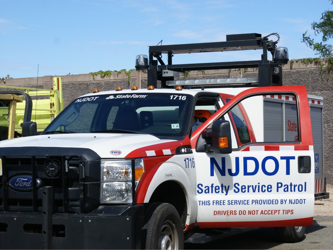
Connected Vehicles Program Pilot Testing of Technology for Safety Service Patrol Workers Continues

Video screenshot of hazard display message received

The rise of crowdsourced navigation applications and connected vehicle applications provide new opportunities to relay road service safety information to the motoring public.  NJDOT has initiated a Connected Vehicle: Road Service Safety Message pilot study that evaluates the effectiveness of using connected vehicle technology to alert the motoring public to the presence of safety service workers at an incident site. NJDOT is piloting the use of a Beacon Hazard Lights technology to alert drivers to the presence of workers when safety service vehicles turn on their hazard lights. The piloting of the technology has received the support of the NJ State Innovation Council (NJ STIC) and a STIC Incentive Funding grant of $39,600 awarded by FHWA.

The primary objective behind the initiative is to inform the public of the presence of Safety Service Patrol (SSP) personnel thru various services and applications that share real-time traffic and roadway information once they have responded to an incident or to help a motorist.  A short demonstration video of how a technology-equipped NJDOT safety service vehicle interfaces with crowdsourcing platforms in the field can be accessed here.

Periodic interim reports for the pilot study are being prepared to evaluate the technology’s application during the STIC grant period. Previously, NJDOT and New Jersey Institute of Technology (NJIT) personnel conducted a field evaluation of the technology following the device-equipped SSP vehicle then subsequently maintained a data log of the device’s activity in the field and through mobile and web-based interfaces.  In continuation of this effort, the NJIT team proceeded with a similar analysis by studying the correlation between the data recorded via the device log and the crowdsourced navigation applications web-based interface. In addition, the radio logs maintained by the Safety Service Patrol were used to further support this evaluation effort.


Making Work Zones Smarter: Data-Driven Decision Making

In honor of Work Zone Safety Awareness Week, the NJDOT Bureau of Research hosted a Lunchtime Tech Talk, “Making Work Zones Smarter: Data-Driven Decision Making” on April 11th.  Dr. Thomas M. Brennan from The College of New Jersey discussed his research using probe vehicle data – that is, anonymous vehicle speed data — to inform the development of work zone mobility performance measures and “Smart Work Zone” congestion management strategies.

Dr. Brennan described how probe vehicle data can be applied to work zone planning.

An important goal of Dr. Brennan’s research has been the development of mobility performance measures that align with the transportation agency’s goals to improve reliability and speeds and diminish delays, queuing, and user costs.   In his talk, Dr. Brennan demonstrated how probe vehicle data collected from a public agency or commercial vendor can be converted from its raw form into mobility performance measures and compelling visualizations for decision-makers to use in formulating appropriate work zone policies and procedures.

He outlined a case study design framework and the steps needed for analyzing work zone effects on mobility performance measures. He described the types of information needed to conduct a work zone mobility audit, including traffic flow and work zone activity data. Using anonymous vehicle speed data, information about traffic slowdowns within the designated area can be gathered.   With enough data points stored over time – and with the appropriate performance measures and visualizations – it is possible to evaluate whether a work zone is increasing congestion as a result of the roadway system, as a result of the type of construction being undertaken, or some combination of both.

Dr. Brennan described the research he has performed in work zones in both Indiana and New Jersey, including an example of road closures of Route 80 in New Jersey. He found that, by gathering speed data alone, one could make an informed observation on when road work was being done and the effects on the surrounding road system. The data measured the impacts of work zones before, during, and after a project’s completion, showing the total “life-cycle” effect of a work zone.

Dr. Brennan noted several types of decisions that state agencies must make to implement a data-driven approach to work zone management.   For example, state agencies will need to select the types of work zones to apply the information, determine appropriate performance measures, define appropriate criteria for “congestion” thresholds, establish the right level of geographic detail and frequency for monitoring and measuring performance, and identify strategies to manage poorly performing work zones.  High-level agency strategies must also be put in place for efficiently archiving the various data that is collected, defining appropriate agency-wide performance measures and standards, and whether to incentivize contractors based on mobility performance measures, among other considerations.

Visualization of performance thresholds for speed, delays travel times.

During the course of the talk, Dr. Brennan highlighted various ways in which probe vehicle data can be used to characterize the reliability, resiliency and congestion at the regional and granular level to inform work zone planning. He hopes to use traffic flow data and work zone activity data to develop a comprehensive guide on how best to predict future congestion. Such data would combine the type of work zone (e.g., lane closures, patching, ramp closures, etc.) with archived data showing how previous similar events had affected the road system. This information could be used to provide agencies with alternative designs for future work zones, and provide drivers with alternative routes, thereby improving the safety and capacity of a work zone for workers and travelers alike.

Resources

Brennan, T. (2019).  Making Work Zones Smarter: Data Driven Decision Making (Presentation)

Brennan, T. M., Venigalla, M. M., Hyde, A., & LaRegina, A. (2018). Performance Measures for Characterizing Regional Congestion using Aggregated Multi-Year Probe Vehicle Data. Transportation Research Record, 2672(42), 170–179. https://doi.org/10.1177/0361198118797190

Remias, S., T. Brennan, C. Day, H. Summers, E. Cox, D. Horton, and D. Bullock (2013). 2012 Indiana Mobility Report: Full Version.  https://docs.lib.purdue.edu/imr/4/


New Jersey Pilots Connected Vehicles Program to Protect Safety Service Patrol Staff

NJDOT safety service patrol vehicle. Source: NJDOT

Each day New Jersey’s safety service patrol (SSP) workers put their own safety at risk to assist motorists in need and to assist other first responders. In addition to warning other motorists about recent traffic incidents, they remove disabled vehicles, provide gasoline, and perform vehicle repairs. Safety service patrol workers use temporary signage, traffic cones, flares, and portable variable message signs (PVMS), existing overhead message signs, the NJ511 phone and website systems as well as the SafeTrip application to warn motorists about their presence.

Unfortunately, collisions involving safety service patrol workers still occur. Cars often travel at excessive speeds near staff who work on the scene of such collisions. In 2015, the Federal Highway Administration (FHWA) reports that a work zone crash occurred once every 5.4 minutes in the United States. The impact of crashes can be catastrophic. Every day 70 work zone crashes occurred that resulted in at least one injury, while every week 12 work zone crashes occurred that resulted in at least one fatality. The NJDOT’s continued efforts to reduce work zone fatalities since the 1990s has resulted in one of the lowest rates in the nation. Despite this, at least one service worker has died in a New Jersey work zone each year since 2007. In 2016 seven fatal crashes occurred in New Jersey work zones, including the death of one service worker.

The automobile manufacturing industry is in the technology development phase of putting connected and automated systems fully in place.  Once deployed, first responders and/or their response vehicles would be detected by these systems to prevent crashes resulting from oncoming traffic.  Until those systems are deployed, the most used applications to alert motorists to roadside incidents, stopped police vehicles and other types of hazards is by Google, Waze, or HERE.

To help ensure the safety of service patrol staff, NJDOT has initiated a pilot study that will examine the effectiveness of using connected vehicle technology to alert the motoring public to the presence of safety service workers at an incident site. Starting in September 2018 NJDOT will pilot the use of a Beacon Hazard Lights technology to alert drivers to the presence of workers when safety service vehicles turn on their hazard lights. The piloting of the technology has received the support of the NJ State Innovation Council and a State Innovation Council Incentive Funding grant of $39,600 awarded by FHWA.  More information about the STIC Incentive Funding source can be found here.

According to Ross Scheckler, the managing partner of iCone, the product supplier for the hazard light technology to be piloted in the NJ study, the firm seeks to build technologies that will increase the availability of data about work zones to the traveling public.  Their tools alert drivers in real-time to the presence of workers, lane-closures and construction related back-ups by making them available on the cloud, where state traffic centers and navigations companies like HERE and Waze can pick them up.  A primary goal of the technology is to let drivers of vehicles know that the rescue truck or the flagger is in the road miles ahead so that the driver or the automation system can slow down and move over, or maybe choose a different route.

In the New Jersey pilot program, the iCone technology will transmit the location of worker vehicles within two minutes of the activation of a vehicle’s hazard lights. The location updates every 15 minutes and is re-transmitted if the vehicle moves more than 500 feet.

Data from 31 SSP vehicles will alert drivers via 511NJ as well as mapping & traffic apps

Thirty-one Safety Service Patrol (SSP) vehicles in Harding and Cherry Hill Yards will pilot iCone’s GPS technology to alert drivers using the 511NJ website and mapping, and traffic apps including Google Maps, Waze, and Here.  A Texas DOT study found that deploying iCone’s traffic beacons reduced crashes at a busy highway up to 45 percent (WorkZoneSafety.org). In addition, beacons deployed on roads resulted in crash cost reductions between $6,600 and $10,000 per night. Arlington is one of more than 450 partners including city, state and country government agencies, nonprofits and first responders to partner with the Waze Connected Citizen Partner program, a free data-share of publicly available traffic data, to deliver road and construction work information to cars.

Different states have used iCone’s technology in various ways, according to Mr. Sheckler. For example, Nevada has focused on relaying lane closures through iCone’s “Smart Arrow Board” modification product. Colorado on the other hand, has focused on the location of traffic cones around work zones through the ‘iPin’ product.  New Jersey’s initiative will examine the effectiveness of iCone’s technology on service patrol vehicles.

One benefit of the approach being tested is that the data appears to be comparatively low-cost and effective in reaching the traveling public through available traffic flow applications.  Mr. Scheckler, iCone’s product supplier representative, notes that most states can quickly accommodate to the data flow that the firm produces since the data feed is modeled off the Waze format.  “When states aren’t ready to integrate the data flow, the data still goes out to millions of cars through partners like Waze, HERE and Panasonic. This works so well that in states that haven’t started picking up the feed, we still have contractors using our equipment because they want their workers to show up in the car.”

iCone’s Vehicle Hazard Light Radio Adaptation GPS device. Source: iCone

In New Jersey, one of the program’s goals is to enhance awareness of the State’s Move Over Law enacted in 2009. The law requires a driver who sees an emergency safety vehicle to approach cautiously and, if possible, make a lane change into a lane not adjacent to the emergency vehicle. Emergency safety vehicles include those operated by fire or police departments, ambulance services, tow trucks and highway maintenance or emergency service vehicles, many of which display flashing yellow, amber or red lights. Drivers must create an empty lane of traffic or prepare to stop, if possible, or face fines of no less than $100 and a much as $500.

NJDOT plans to evaluate the success of the program during Year 1 and determine interest and opportunities for collaboration with transportation agencies in other states and first responder organizations. NJDOT is part of TRANSCOM (XCM), a coalition of 16 transportation and public safety agencies that improves communication and technology by the use of traffic and transportation management systems and in partnership with technology companies. XCM currently provides NJDOT incident data to Google, Waze, and Here as well as the 511NJ web and phone platform, however SSP vehicle location data is not integrated into any of these programs.

Sources:

Cowan, S. (2018). Spring 2018 STIC presentation: Connected Vehicle — Road Service Safety Messages. Retrieved from: https://www.njdottechtransfer.net/wp-content/uploads/2018/04/CIA-Team.pdf

Hsieh, E. Y., Ullman, G. L., Pesti, G., & Brydia, R. E. (2017). Effectiveness of End-of-Queue Warning Systems and Portable Rumble Strips on Lane Closure Crashes. Journal of Transportation Engineering, Part A: Systems, 143(11), 04017053. Retrieved from:  https://ascelibrary.org/doi/abs/10.1061/JTEPBS.0000084

National Work Zone Safety Information Clearinghouse. (c2016). 2016 New Jersey Work Zone Fatal Crashes and Fatalities. Retrieved from https://www.workzonesafety.org/crash-information/work-zone-fatal-crashes-fatalities/#new%20jersey

Ullman, G. L., Iragavarapu, V., & Brydia, R. E. (2016). Safety effects of portable end-of-queue warning system deployments at Texas work zones. Transportation Research Record: Journal of the Transportation Research Board, (2555), 46-52. Retrieved from https://doi.org/10.3141/2555-06