

Introduction
In the summer of 2017, the Federal Highway Administration (FHWA), through a competitive application process, selected NJDOT as one of six (6) state DOTs to participate in a pilot program focused on extreme weather, climate risks and asset management. Each state is to prepare a case study that demonstrates how extreme weather and climate risks are integrated into asset management. FHWA intends to use the results of this effort to develop guidance materials to assist State DOTs in integrating extreme weather and climate risk into asset management practices, specifically in life cycle planning. Statewide Planning, Safety, and Capital Investments’ (SPSCI) Divisions of Environmental Resources and Statewide Planning have combined resources to undertake this endeavor that began in October 2017 and is to be completed by February 2019.
Extreme Weather Considerations Vary by State
The six (6) states selected for the Pilot program are Arizona, Kentucky, Massachusetts, Maryland, Texas and New Jersey, giving a diverse geographic perspective. Extreme weather involves different stressors dependent upon location. Whereas riverine flooding associated with heavy precipitation is the “extreme weather” condition that New Jersey and Texas have focused on, Maryland has focused on sea level rise and coastal flooding. Kentucky is focusing on both riverine flooding and other secondary extreme weather hazards from excessive rain such as landslides and sinkholes. Arizona has indicated that they often experience extreme weather in the form of excessive heat, wildfires and dust storms, as well as flash flooding from excessive rain. Finally, Massachusetts, also concerned with riverine flooding, is pursuing the development of a “stream power” tool to assist in assessing extreme weather impacts to their bridges and culverts.
New Jersey’s Approach
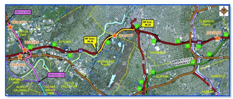
Case Study Area (Photo Credit: SPSCI)
Originally selecting culverts as the “asset class” to investigate impacts of extreme weather, the New Jersey study has refocused more on identifying the root causes of flooding in specific areas to target cost-effective risk management and mitigation strategies. Using the Departments’ Drainage Management System (DMS) as the primary tool for identifying vulnerable areas subject to road closures due to severe precipitation such as flooding and/or icing, the study team has focused on two locations:
- Portions of the I-80 corridor, milepost 56.43 – 58.22, ranked # 1 in 2016 DMS.
- The intersecting Route 23 corridor milepost 4.00 – 7.00, ranked 14th on the 2016 DMS.
Culverts within these limits were identified as well as drainage systems, roadway conditions, topography, flood elevation mapping, and other pertinent data to fully understand the root causes of flooding at these vulnerable areas, and to see how projected climate changes could affect them. Once root causes are identified, then appropriate mitigation strategies can be developed to maintain a state of good repair in extreme weather conditions as best possible.
Communications: Key to Success
The ongoing study has seen early success by engaging internal and external stakeholders; promoting the need and value of cross communication among asset managers, engineers, planners, environmental and maintenance staff. Input from the “owners” of the Drainage Management System, Maintenance Management System, GIS, as well as designers for active projects in the study area from CPM all played key roles in providing critical information, assisting in developing findings for this effort. Maintenance crews have provided real time information related to recent extreme weather events, describing activities needed to further resiliency efforts in the study corridors. Finally, collaboration with NJTPA’s Passaic River Basin Resilience study has resulted in the sharing of critical flooding and climate forecasts to further assist in developing our Pilot Study. Together, the ongoing cross-communication has been the most valuable tool in developing this study, and has laid the groundwork for ongoing discussions on the subject of extreme weather, asset management, and transportation resilience.
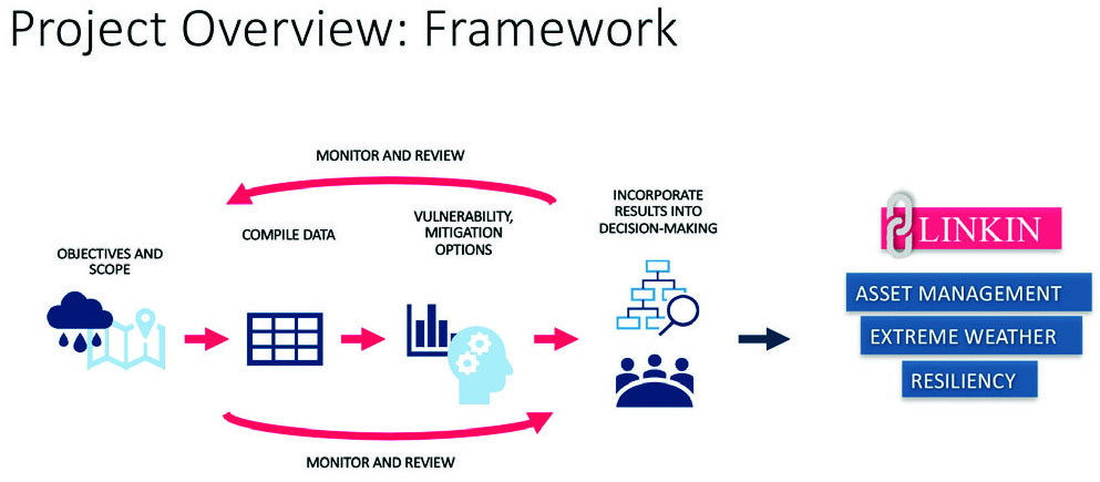
Project Overview: Framework (Photo Credit: SPSCI)
Early Findings
Addressing extreme weather and asset management cannot be handled in a broad sense as each asset has its own uniqueness in determining its sensitivity to extreme weather. Also, not all assets are vulnerable to projected climate forecasts. To truly address asset management and extreme weather, appropriate tools need to be developed, preferably in GIS format, to fully identify all assets that are vulnerable to extreme weather (excessive precipitation), then determine what mitigation strategies are needed to enable these assets to be resilient and maintain a state of good repair for New Jersey’s vast transportation network. Final recommendations on how to address extreme weather considerations in asset management will be a part of the final study and will serve as a starting point to address resiliency in the Department’s practices.
Contributed by Elkins Green
Featured image (top) is case study area #1: I-80 between M.P. 56.43 and M.P. 58.22. Photo Credit: NJDOT Aeronautics UAS Photo
This article first appeared in the December 2018 SCOOP, the employee newsletter of Planning, Multimodal and Grant Administration, “SPSCI Divisions take lead on Extreme Weather, Climate Risks, and Asset Management: Quest for Resiliency.”