NJDOT Traffic Incident Management Training Course – Now Available Online as Self-Guided Course

The New Jersey Department of Transportation’s Traffic Incident Management (NJTIM) training is now available as an online, self-guided course. Bringing first responder training program to an online training platform should make it easier for even more emergency and incident response personnel to access a life-saving training. The new online course can be accessed through the NJTIM website.

The TIM training program focuses on a response effort that protects motorists and first responders during a roadside emergency, while minimizing impact on traffic flow. Since its inception in 2009, NJDOT and its partner agencies have trained more than 24,000 emergency and incident response personnel, including police, firefighters, EMS personnel, DOT crews, towing/recovery companies and other responders.

Training efforts, like these, are crucial in coordinating response efforts that keep all first responders and transportation professionals safe.

The new online training course can be found at NJ TIM Website: njtim.org

Providing easier access to TIM training for busy first responders and transportation professionals should prove more cost effective than traditional, in-person meetings for organizations with limited budgets. The online training program is asynchronous, offering greater flexibility in taking the training for personnel whose work schedules may not align with in-person training dates.

Online programs can also be easily updated and revised, ensuring that participants receive the most current and relevant information.

The online training is designed to engage training participants with videos, simulations, knowledge checks, and interactive scenarios that mimic real-world situations. The online TIM training utilizes assessments and certifications to evaluate the trainees’ understanding of the material and practice decision-making in high-stress scenarios without real world consequences.

The online TIM training program seeks to improve safely and coordination in responding to incidents on New Jersey’s roadways. The target audience for this training is county and municipal law enforcement and emergency personnel, including volunteer firefighters and EMTs.


FHWA’s Every Day Counts Program has recognized the importance of TIM as model safety and mobility innovation. In Round 6, Next-Generation TIM: Integrating Technology, Data, and Training, the importance of training of local agencies was encouraged.

The FHWA’s Talking TIM webinar series provides best practices, new technological innovations, and successful implementations. The webinar series provides a forum where TIM champions with any level of experience can exchange information about current practices, programs, and technologies.

More information on the rationale and benefits of the new course can be found in the video and the NJDOT press release.

Image of backed up traffic and first responder in neon vest standing on highway

Talking TIM Webinar Series (TIM) Webinar Series

The Federal Highway Administration's (FHWA) Talking TIM webinar series provides best practices, new technological innovations, and successful implementations. The webinar series provides a forum where TIM champions with any level of experience can exchange information about current practices, programs, and technologies.  Each month, the FHWA TIM Program Team seeks to feature content that highlights successful programs, identifies best practices, and showcases technology that advances the profession.

The FHWA-sponsored webinars are hosted by the National Operations Center of Excellence (NOCoE). Talking TIM typically takes place the fourth Wednesday of each month from 1:30 PM – 3:00 PM.  Click here to view upcoming webinars.

Below is a list of past webinars:

  • January 2021: The International Association of Fire Chiefs (IAFC) Role in TIM, Digital Alert Pilots in St Louis and Kansas City, and FHWA Every Day Counts Round Six (EDC-6) NextGen TIM Overview
  • February 2021: Innovative Tools for Responder and Road Worker Safety
  • March 2021: AASHTO's Role in TIM, Nebraska Tow Temporary Traffic Control Program, Fire Truck Attenuators for Temporary Traffic Control, Massachusetts Legislation for Driver and Responder Safety
  • April 2021: Wisconsin's Traffic Incident Management Enhancement (TIME) Program, City of Seattle TIM and Response Team Program, and North Central Texas Council of Governments (NCTCOG) TIM Innovations
  • May 2021: National Highway Traffic Safety Administration's (NHTSA) Role in TIM, Incident Detours Involving Railroad Crossings, Washington State's TIM Program and Virtual Coordination, and Responder Vehicle to Traffic Management Center Video Sharing
  • June 2021: Unmanned Aerial Systems (UAS) for Traffic Incident Management
  • July 2021: Lubbock Fire and Rescue Helmet Innovation,  RESQUE-1 Electric and Hybrid Vehicle Assistance, Geographically-Tagged Information from Travelers
  • August 2021: CDOT TIM for Localities, Texas Commission on Law Enforcement TIM Training Requirement, Schertz Fire and Rescue TIM Training Institutionalization, Institutionalizing TIM training for EMS Professionals in Georgia
  • September 2021: Rural Roadway Strategies for Incident Management
  • October 2021: Autonomous Truck Mounted Attenuator Testing and Implementation in Colorado, Autonomous and Driverless Pilots for Large Trucks in Arizona, Rural-Focused Towing Programs in Florida
  • November 2021: National Kickoff: Crash Responder Safety Week 2021
  • December 2021: In-Cab Incident Alerts for Commercial Vehicles
  • January 2022: Illinois TIM Program Overview and Training Video Use, Law Enforcement and First Responder Interactions Plans for Automated Driving Systems (ADS), Total Solar Eclipse Planning for 2023 and 2024
  • February 2022: Public Safety Announcements across Nine States for Motorist and Traffic Incident Responder Safety, TIM Video Sharing Use Cases: Findings from the Recent EDC-6 Next Generation TIM Workshop, TRACS and MACH: Software to Simplify Electronic Crash Reporting and Computer Aided Dispatch (CAD)
  • March 2022: Outreach for Responder Safety through Collaborations with the American Automobile Association (AAA) and the Towing and Recovery Association of America, North Carolina Tethered Unmanned Aircraft Systems (UAS) Program, and Advanced Responder Warning through Safety Vests Fueled by Video Analytics
  • April 2022: Smart Lighting Strategies for Responder Vehicles, Incident Response After Action Reviews Using Unmanned Aerial Systems (UAS) Imagery, Incident Response After Action Reviews Using Unmanned Aerial Systems (UAS) Imagery
  • May 2022: Data Use and Visualization, Promoting Roadway Safety Through Move Over Law and Responder Struck-By Awareness, The New Jersey TIM Program
  • June 2022: Ohio DOT Quick Clear Demonstration, Electric Vehicle Battery Fires and the TIM Timeline, Montana's TIM Program
  • July 2022: The National Unified Goal: What Is It and How Do We Make It Relevant?, Planning and Responding to Special Events in Minnesota, Iowa DOT TIM Program Overview and Strategies for Quicker Incident Detection
  • August 2022: Overview of the Florida Heartland TIM Committee and Florida's Expanded Deployment of Cameras on Road Ranger Vehicles, What's New for the 2022 TIM Capability Maturity Self-Assessment, The TIM National Unified Goal: Relevancy of the TIM NUG Strategies
  • September 2022:  Move Over and Responder Safety Technologies, Houston Traffic Incident Management and Training
    National Unified Goals Review and Feedback.
  • January 2023:  Mitigating Work Zone Traffic Incidents Using Unmanned Aircraft Systems (UAS), Every Day Counts Round 7 (EDC-7) Innovation, Next Generation TIM: Technology for Lifesaving Response, Traffic Incident Management National Unified Goal (NUG) Review and Feedback, Part 3
  • February 2023: Findings from Move Over Compliance and Responder Safety Technology Research, After Action Review of a Multi-Vehicle Fire, EDC-7 Summit Debrief: TIM Technologies for Saving Lives.
  • March 2023: Light-emitting diode (LED) Temporary Traffic Control Devices for Digital Motorist Alerts, Moveable Barriers and Debris Removal Systems, National Secondary Crash Research.
  • April 2023:  Responder to Vehicle (R2V) Alerts in the District of Columbia, The Role of Medical Examiners in TIM, New Audience Listening Session

Go to Talking TIM webinar series for more recent events.

More  information on the FHWA EDC-7 initiative, Next Generation TIM: Technology for Lifesaving Response is here.

Jim AustrichPaul Jodoin, and Joe TeboFHWA Office of Operations TIM Program, organize and moderate this webinar series hosted by the National Operations Center of Excellence (NOCoE).


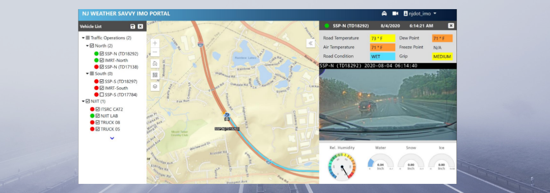
Innovation Spotlight: Testing and Deploying ITS Solutions for Safer Mobility and Operations

NJDOT’s Transportation Mobility unit is working on several initiatives related to FHWA Every Day Counts innovative initiatives, including: Crowdsourcing for Advancing Operations (EDC-4, EDC-6), Next Generation Traffic Incident Management (EDC-4, EDC-6), and Weather Responsive Management Strategies (EDC-4, EDC-5).  The unit has been creatively deploying STIC Incentive Grants and Accelerated Innovation Deployment (AID) grants to pilot test and evaluate innovations in recent years. We spoke with Sue Catlett, Project Manager in the Mobility Research Group, to provide updates on this work and discuss the coordination needed between agencies, organizations, and industry to make progress on these initiatives, and the barriers to deployment.

The Waycare crowdsourcing platform will feed information to NJDOT’s traffic operations centers to help resolve traffic issues and improve safety.

Crowdsourcing for Advancing Operations

Q.  Can you give us an update on the STIC incentive grant and the pilot of the Waycare crowdsourced data platform?

Waycare is in the DOT’s procurement process.  Once we have access to the information, the pilot will begin. We hope to see an increased situational awareness of the roadways.

Q.  Once it is deployed, will you have data coming in immediately?

We anticipate that we will have data but we will need to evaluate what that data means to us. For example, a key consideration is the definition of terms such as “crash incident,” and “accident.” We need to determine if we accept what the system’s definition of a term is or if we can set a definition.

Once the Waycare system is operating, NJDOT’s Intelligent Transportation Systems Resource Center (ITSRC), housed at New Jersey Institute of Technology (NJIT), will be working with NJDOT on the evaluation of the information coming in and matching it up with other information that DOT is utilizing.

Next Generation Traffic Incident Management

Q.  Can you update us on the deployment of the Computer Aided Dispatch (CAD) integration with the State Police?  At the 3rd Quarter STIC meeting in September 2021, you mentioned that the State Police had deployed their CAD system and are still doing some fine-tuning.

The State Police deployed their system at the end of June and are continuing to make adjustments to the system and train staff in its use. They will be building out the system by adding modules. We are working with the State Police to determine how we will have access to the information gathered and we are working towards an agreement.

Q.  Traffic Incident Management must require coordination with numerous organizations, yes?

The Department promotes the safety of traffic incident first responders through their Move Over campaign.

Yes, in fact, we just had our statewide Traffic Incident Management (TIM) meeting today where we reported out on what we have been working on, what we will be doing in the next six months, and what help we will need from others. The various participating groups also report out. TIM involves coordination with first aid, EMS, the State Police, the MPOs, municipal fire departments, the Department of Health, and many others. We have been working on the Move Over bumper sticker campaign, and the National Crash Responder Safety Week was in November, so there are a lot of initiatives that we are working on through the year with a purpose of reducing time an incident is on a roadway and keeping first responders safe while responding to an incident.

Q.  Has there been any progress on establishing an Advanced Traffic Management System (ATMS) platform or core software? What are the steps involved? What are you ultimately looking for with this platform?

In our operations centers, we gather data from many systems such as highway cameras, and travel times, as well as other information. The ATMS platform would combine these multiple platforms into one so that NJDOT operators can look in one place for all the information collected. The State Police CAD data could be included in this core software system.

We want one platform for our existing systems and we are also looking towards what we will need in the future. We worked with an engineering consultant firm to determine required elements, desired elements, and future needs. We were looking for a vendor that has a system that was already built and could then be customized to meet the Department’s needs. Any system would need to work with systems that DOT is currently using. We consulted with NJDOT Safety Service Patrol (SSP) and electrical maintenance, among others, to see what future needs they could anticipate. We wanted to cast a wide enough net to avoid missing something that other groups can anticipate now that they would need later on. We also talked to other state DOTs to receive feedback about their systems.  The pandemic slowed progress on this effort and we have not contracted with a vendor yet.

It is anticipated that the platform will be built out through the addition of modular components. This makes it difficult to predict when the platform will be ready to use.

Weather Responsive Management Systems (WRMS)

Q.  Congratulations on receiving the ITS-NJ 2021 Outstanding Project Award for the Weather Savvy Roads project. What is happening with the project?

The Weather Savvy Roads project was a collaboration with many individuals and organizations.  The project has expanded to 23, and soon to be 24, equipped vehicles. Equipped trucks include six Safety Service Patrol vehicles (3 north, 3 south) which operate 24/7, two incident management response (IMRT) trucks which can respond to incidents at any time (1 north, 1 south), and Operations vehicles including 7 snow plow vehicles (3 north, 2 central, 2 south) and pickup trucks used by supervisors who can respond where needed. We are still working on modifications and analysis of the data we have received.

Weather Savvy instrumentation displays atmospheric conditions and a dashboard view of road conditions in real time.

The Mobile Road Weather Information System (MRWIS) provides information on ambient temperature, road temperature, road condition and grip, as well as a windshield view of road conditions. Management can see what the drivers are seeing. The information helps to assess a storm’s duration and intensity while it is ongoing. The data available through the system has helped management make decisions. For example, last winter a Director referred to the system to determine how much longer crews  would need to be out on the road based on conditions, and could predict another two hours commitment.

WRMS can also assist in traffic incident management. Video of an incident, captured by an NJDOT responder truck, provides much more information than a verbal description of an incident scene. The detail can help ensure that individuals in the field can get the appropriate support and get the road back open more quickly.

NJDOT has extended the pilot deadline to June 2022 to include a second winter using the WRMS. This expansion will allow us to test the system on a potentially wider range of weather conditions, and assess the durability of the equipment. Last winter, NJIT analyzed the information we were collecting and found an issue with the data being reported. The vendor had to change their manufacturing process to address condensation issues and we installed replacement sensors.

Q.  What do you anticipate being the next steps?

We are exploring how to bring this system inside the Department. Currently, the Weather Savvy website is hosted by the ITSRC at NJIT.

Other Innovative Initiatives Underway through Research or Other Activities

Q.  Are there non-EDC innovations being undertaken at NJDOT or elsewhere in NJ that should be highlighted to STIC partners? 

Drivewyze® is a phone app that is used to inform truck drivers of upcoming weigh stations, enabling drive-by of weigh stations, and provides in-cab alerts about slowdowns or other road issues. The Department could use the system to alert truckers to specific conditions, such as truck restrictions on snow-covered roadways before they enter the State, to allow truckers to make adjustments. NJDOT is trying the system out for a year to look at the value of the information and what impact it may have.

We are also using video analytics to look at truck parking in the Harding Truck Rest Area during winter storms. Both commercial trucks and Safety Service Patrol vehicles use this rest area, and the space can become overly full and entrances and exits can be blocked. SSP vehicles need to be able to get into and out of the area to respond to incidents and for shift changes. We installed devices in the parking stalls, which provide information indicating when they are occupied, and cameras identify when trucks are parked in non-marked parking spaces. From the data collected, we hope to determine prime times for usage, and we are trying to find a way to communicate with truckers. NJIT is conducting this study through the ITSRC.


Resources

More Information on the STIC initiatives highlighted in this interview is available using the following links:

Crowdsourcing for Advancing Operations - https://www.njdottechtransfer.net/2021/01/01/crowdsourcing-for-advancing-operations/

Next Generation TIM - https://www.njdottechtransfer.net/2021/04/19/next-generation-tim/

Weather Responsive Management Strategies - https://www.njdottechtransfer.net/weather-responsive-management-strategies/

Developing Next Generation Traffic Incident Management in the Delaware Valley

Traffic Incident Management (TIM) programs help first responders and traffic operators to better understand and coordinate roadway incidents. As part of the sixth round of the Federal Highway Administration’s (FHWA) Every Day Counts (EDC) initiative, the agency is promoting innovative practice in this area through NextGen TIM. These practices and procedures can advance safety, increase travel reliability, and improve agency operations by engaging with new technologies and trainings. For example, sensors and crowdsourced data can help traffic agencies better detect incidents and decrease response times. Drones, or Unmanned Aerial Systems (UAS) can help transportation agencies and first responders better understand the incident scene and speed the resumption of traffic flow. The NextGen TIM initiative is an effort to improve traffic incident management through technological innovation and standardized operating procedures. NextGen TIM technologies and practices are currently being used in the Delaware Valley to increase real-time situational awareness and ensure maximum safety at the scene of an incident.

Regional Integrated Multimodal Information Sharing (RIMIS)

Image of RIMIS Operational Tool, which is a map of the DVRPC region, with Philadelphia at the center, and portions of New Jersey to the east, and Pennsylvania to the West, highway routes are marked in green and yellow, yellow denoting slower than usual operations, orange construction worker signals denote construction along the corridor, many of them are clustered aroudn Philadelphia.

The RIMIS Operational Tool gives a system-wide overview of traffic operations, such as incidents, traffic flow, and construction alerts, courtesy DVRPC

Currently, transportation departments in the region use the TRANSCOM traffic monitoring platform to supervise incidents. The Delaware Valley Planning Commission (DVRPC)’s version of this platform is called RIMIS, or Regional Integrated Multimodal Information Sharing. Because DVRPC is a Metropolitan Planning Organization (MPO) that spans both sides of the Delaware River, its reach includes sections of New Jersey and Pennsylvania—broadly, the greater Philadelphia area. In this region, with overlapping municipal, state, and regional jurisdictions, communication and coordination could be difficult. According to Christopher King, Manager of DVRPC’s Office of Transportation Operations Management, before RIMIS, incident notifications were commonly communicated through phone calls.

Area transportation officials recognized the need for a coordinated platform where information could be shared back and forth. Instead of slow, one-to-one incident notifications, this new, decentralized platform would present a “big picture” perspective of a traffic incident’s impacts on the regional transportation network. The concept was to create a regional centralized information location for traffic operators and first responders to view the traffic status on area roads, and understand, quickly and reliably, where an incident has occurred. Local agencies could access the platform to better understand incident conditions.

Image of 16 video feeds, each of a different stretch of highway, a video wall for traffic operations monitoring.

The RIMIS Video Wall allows for real-time roadway monitoring for first responders and traffic operations personnel, courtesy DVRPC

RIMIS was first developed nearly 20 years ago, and has proved to be invaluable as a resource. Participants supply data, such as video feeds and traffic updates, which is then aggregated to update other members. These agencies include PennDOT, NJDOT, SEPTA, and NJ TRANSIT. Member agencies and municipalities, such as Bedminster Township, PA, can take advantage of the operations database, with live and historical traffic flow and incident data, a situational map which geographically represents traffic levels and incidents across the region, and a video wall of roads in the DVRPC area with live camera feeds.

As an example, Mr. King showed a municipal fire department participating in RIMIS, that, once alerted that a collision has occurred, can access the platform’s interactive map, live video feeds, and information on planned interruptions, to better understand the scene before arriving there. The RIMIS platform gives context to first responders on route to an incident, provides a broader view for traffic operations dispatchers managing a disruption, and also assists transportation planners looking for data on how to improve a high-collision roadway.

Interactive Detour Route Mapping (IDRuM)

Image of a map of Philadelphia, with highway routes in orange, delineated into sections. Each section, when clicked on, shows two detour routes in the event of a serious incident.

IDRuM is a detour resource for rerouting traffic after major incidents, courtesy DVRPC

Another TIM tool DVRPC provides is the Interactive Detour Route Mapping (IDRuM) feature, a web application that consolidates established Emergency Detour Routes as a resource for traffic operations personnel, first responders, and transportation planners and engineers.

If, for example, an incident has occurred on a certain segment of I-295 in Bucks County, then the Primary Detour Route would involve taking Taylorsville Road south and turning right on State Route 322 to rejoin the highway, while the Secondary Detour Route would take a similar maneuver going north. This information can be easily accessed in both interactive and PDF formats on the IDRuM mapping site.

Image of two detour routes from I-295, one goes on a road to the north and then southeast to rejoin the highway, the other to the south and then northwest.

DVRPC is currently beta testing detour routes from NJDOT for the IDRuM platform, courtesy DVRPC

DVRPC is currently working to integrate NJDOT’s designated Detour Routes into the GIS map for the area east of the Delaware. The data has been uploaded, but is still in beta testing.

NextGen TIM

Mr. King says that a chief focus of NextGen TIM is to expand services such as RIMIS and IDRuM to more localities and arterial routes, as well as to ensure that all first responders are trained in the most up-to-date TIM techniques, such as how to position their vehicles for maximum safety on an active roadway.

During the second round of the Every Day Counts Initiative (EDC-2, 2013-2014),  a TIM process and training program was established under the  SHRP2, or the second Strategic Highway Research Program. This laid the groundwork for the current TIM training and organizational infrastructure, which is NJTIM in the Garden State. This consortium, spearheaded by NJDOT, provides resources and trainings to teach best practices to first responders across the state. NJDOT and the New Jersey State Police (NJSP) partner together to promote trainings and coordinate highway emergency response. To learn more about NJDOT’s efforts with regards to partnering with NJSP on crash data consolidation, using Unmanned Aerial Systems for incident analysis, and other aspects of the initiative, please visit NJDOT Tech Transfer’s NextGen TIM page.


Resources

Delaware Valley Regional Planning Commission. Interactive Detour Route Mapping (IDRuM). https://www.dvrpc.org/transportation/tsmo/idrum

Delaware Valley Regional Planning Commission. Regional Integrated Multimodal Information Sharing (RIMIS). https://www.dvrpc.org/Transportation/TSMO/RIMIS/

New Jersey Department of Transportation. Statewide Traffic Incident Management Program. https://www.nj.gov/transportation/commuter/motoristassistance/stimp.shtm

New Jersey Traffic Incident Management. Traffic Incident Management Resource Portal. http://www.njtim.org/NJTIM/

NJDOT’s Traffic Incident Management Training Program

NJDOT’s Traffic Incident Management Program offers training and resources to improve the coordinated response to traffic incidents. Source: NJTIM website

NJDOT’s New Jersey’s Traffic Incident Management (TIM) program consists of a planned and coordinated multi-disciplinary process to detect, respond to, and clear traffic incidents so that traffic flow may be restored as safely and quickly as possible after an incident. According to the 2015 State of New Jersey Traffic Incident Management Strategic Plan, about half of all traffic congestion is caused by temporary, one-time occurrences, such as crashes, disabled vehicles, spilled cargo, highway maintenance and reconstruction, adverse weather, and planned special events. These occurrences reduce roadway capacity, disrupt the normal operation of the transportation system, increase the risk of secondary crashes, and result in lost time and productivity, increased cost of goods and services, negative impacts on air quality and the environment, and reduced quality of life and motorist satisfaction.

Training classes include incident resolution exercises. Source: NJTIM website

Training classes include incident resolution exercises. Source: NJTIM website

By reducing the duration and impact of traffic incidents, effective traffic incident management practices improve the safety of crash victims, other motorists, and emergency responders. TIM practices are designed to reduce the time to detect, respond to, investigate, and safely clear the incident, to safely manage personnel and equipment at the site, provide timely and accurate information to the public, and to manage affected traffic until normal conditions are restored. Stakeholders in the Traffic Incident Management program include federal, state, and local agencies and private sector partners including emergency medical services (EMS), fire and rescue, law enforcement, transportation agencies, medical examiners and coroners, hazardous materials contractors, towing and recovery, emergency management, public safety communications, and traffic information media.

The FHWA’s Every Day Counts (EDC) program, in cooperation with the second Strategic Highway Research Program (SHRP2), offered the first national traffic incident management process and training program as an innovation under EDC-2 in 2013-2014. First offered in 2010, NJDOT’s classes in TIM predated the FHWA EDC initiative. The NJ TIM Responder Training provides interactive, hands-on incident resolution exercises to help participants learn to coordinate incident response activities and optimize operations in the field. The training supports development of a unified practice among all stakeholders. NJDOT has continued to train in TIM during the pandemic and, as of September 1, 2020, the program has trained 29,798 incident responders.

NJDOT and the ITS Resource Center at NJIT have updated the NJTIM website. Source: NJTIM website

NJDOT and the ITS Resource Center at NJIT have updated the NJTIM website. Source: NJTIM website

In alignment with the 2015 Strategic Plan, NJDOT and the ITS Resource Center at the New Jersey Institute of Technology, developed the NJ TIM website in 2016 to provide support to the TIM program. Recently, they have modernized the website through the addition of new content, including videos and other resources such as case studies and training recaps. A schedule of virtual trainings, and registration for individual and group training, are available. The website provides links to the Strategic Plan and Safety Guidelines for Emergency Responders, as well as contact information for all federal, state, county, and local law enforcement agencies operating in the state.

Video screenshot of hazard display message received by motorists. Source: NJDOT

Through EDC-4, FHWA promoted the use of data to improve traffic incident management. NJDOT is increasingly looking to technology to improve safety at incident sites. A pilot study looked at the effectiveness of using connected vehicle technology on 32 safety service vehicles to alert drivers to the presence of safety service patrol (SSP) workers via the mobile navigation app Waze. NJDOT established a Computer-Aided Dispatch (CAD) Integration Working Group to develop a plan for CAD integration among New Jersey agencies and other organizations. Using the OpenReach system, NJDOT has implemented the FHWA key performance measures: roadway clearance time; incident clearance time; and number of secondary crashes. Traffic incident management data sharing between the NJDOT and law enforcement systems is expected to decrease incident response times, properly capture the incident timeline, and improve the traffic incident management process. More information on these efforts can be found at the NJDOT Technology Transfer website.