How New Jersey Counties are Reducing Rural Roadway Departures

Reducing fatalities on rural roads is a key challenge for transportation agencies in the United States, where roadway departures on rural networks account for one-third of traffic fatalities. The Federal Highway Administration (FHWA) has identified safety countermeasures that are proven to improve rural roadway safety and reduce the number of traffic deaths. In the fifth round of the agency’s Every Day Counts (EDC) State-based model, FHWA identified “Reducing Rural Roadway Departures” as a proven, yet underutilized, innovation. The four pillars of the initiative are: all public roads, proven countermeasures, a systemic approach, and safety action plans. FHWA Proven Safety Countermeasures for rural roadway departures fall into three broad categories: helping drivers stay in their lane, reducing the risk of a crash with lane departures, and minimizing the severity in the case of a crash. Specifically, FHWA safety countermeasures related to rural roadway departures include rumble strips and stripes, SafetyEdgeSM, high friction surface treatment, and backplates with retroreflective borders. A recent FHWA video, Focusing on Reducing Rural Road Departures, provides information on how these low-cost measures help drivers stay in their travel lanes and reduce the potential, or minimize the severity, of rural roadway crashes.

Through EDC, FHWA seeks to support rapid deployment of identified initiatives at the State and local level, which results in cost, time, and resource savings. As of December 2019, New Jersey is in the “development” phase of the Reducing Rural Roadway Departures initiative; NJDOT is collecting guidance and best practices, while building support with partners and stakeholders to develop an implementation process. The goal is to reach the “demonstration” stage by the end of EDC-5 (December 2020), when they would begin testing and piloting the innovation.

In order to achieve this goal, NJDOT seeks to improve the knowledge of rural roadway facility owners and maintainers through training, with the assistance of the FHWA Resource Center. In 2018 and 2019, FHWA and NJDOT hosted a series of Local Safety Peer Exchanges at which engineering staff from Cumberland and Somerset counties shared their experience with implementation of countermeasures on high risk rural roads (HRRR).
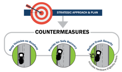
FHWA’s Strategic Approach and Plan to reduce roadway departure crashes and fatalities. Photo Source: FHWA, 2019.

The Cumberland County Engineering Office manages infrastructure that includes 540 miles of county roads, 50 traffic signals and flashers, 54 bridges, and 169 minor bridges. One important source of funding for their work is the Highway Safety Improvement Federal-aid Program (HSIP). The purpose of HSIP is to achieve a significant reduction in highway fatalities and serious injuries on all public roads, using a data-driven, strategic approach focused on improving performance. The County focuses on two types of projects for HSIP: systemic projects and “hot-spot” projects. Systemic projects apply a given improvement method over a large number of applicable locations in order to deter “random” crash events and reduce risk across an entire roadway system.

Hot-spot projects need more in-depth data collection and analysis to determine appropriate site-specific improvements related to crash history. To collect data for hot-spot projects, South Jersey Transportation Planning Organization (SJTPO), the regional Metropolitan Planning Organization (MPO) for Cumberland County, worked with Rutgers University’s Center for Advanced Infrastructure and Transportation (CAIT) to use NJDOT’s Plan4Safety multi-layered decision support tool to create four network screening lists for the region. Each list provided weighted scores for a given timeframe based on a location’s number and severity of crashes. The four screening lists identify pedestrian intersection hot spots, pedestrian corridor hot spots, intersection hot spots, and HRRR hot spots.

Selecting the appropriate countermeasure is critical to project success. When using network screening lists, the countermeasure should address the particular type of crash occurring at the location, while countermeasures used with the systemic approach should address the specific geometric trait(s) that are related to the specific crash type.

Cumberland County highlighted two countermeasures at the Peer Exchange: centerline rumble strips and high friction surface treatment on horizontal curves. Centerline rumble strips reduce the risk of cross centerline crashes and are often part of a systemic approach. With the help of NJDOT’s Bureau of Transportation Data and Safety, SJTPO created a candidate list of potential centerline rumble strip locations. NJDOT’s criteria limit installation to two-lane urban or rural roadways with a 20-foot minimum pavement width, and a speed limit of 35 mph or greater. In addition, Cumberland County limited installation to asphalt roadways 10 years old or less in less dense residential neighborhoods due to the noise the rumble strips produce. Based on these criteria, the County selected approximately 150 roadway miles across 11 municipalities. Installation was performed at night to lessen the impact on traffic, improve safety conditions for construction workers and inspectors, and shorten installation time.
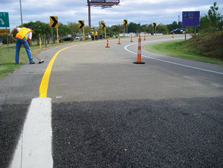
HFST installation at a horizontal curve. Photo Source: FHWA, 2018.

The second method, high friction surface treatment (HFST) on horizontal curves, addresses the challenges that horizontal curves pose due to the change in alignment that can cause issues for driver navigation, especially at night or in inclement weather. According to data analysis cited by SJTPO, 28 percent of fatal crashes nationwide occur on horizontal curves. HFST compensates for the high friction demand at the curves in areas where the current pavement condition does not adequately support operation speed, due to a number of factors such as sharp curves, wet conditions, polished roadway surfaces, inadequate cross-slope design, and driving speeds above the curve advisory speed. HFST are proven to reduce wet road crashes by 52 percent and curve crashes by 24 percent according to the FHWA. Additionally, these treatments are safe for all vehicle types and have high durability. However, the county engineer also noted the high unit cost and the lack of contractors within the region capable of HFST installation. When properly installed, the pavement life is equal to, our greater than, asphalt pavement but improper installation potentially limits the usefulness and life expectancy of the pavement treatment.

Locations were selected from the HRRR list, along with spots familiar to the Engineering Department based on geometry, crash history, residential input, and municipality information. Additionally, pavement condition was taken into consideration as a factor that could affect the treatment’s durability.

Cumberland County staff highlighted the importance of updating and upgrading existing safety features during the project such as size, location, spacing, and retroreflectivity of signage. They noted important considerations moving forward: data used in the network screening lists is aging; the rumble strip projects had a long delivery timeline of 22 months from application submission to construction notice to proceed; and the centralized project review process eliminated interactions with the local public agency which tends to have the most detailed knowledge of the project area.
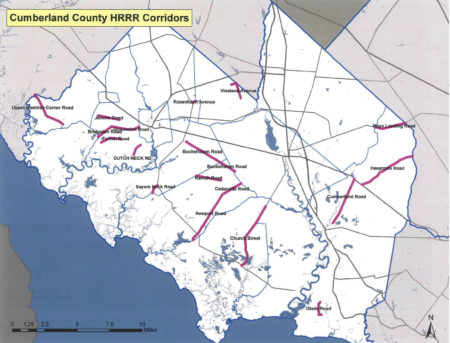
Cumberland County High Risk Rural Roads Locations in Cumberland County. Photo Source: Whitaker, 2018.

A representative of the Somerset County Engineering Office shared their systemic safety approach to horizontal curves with high friction surface treatment. The Engineering Office manages infrastructure for 250 miles of county roads, 193 traffic signals, and 762 bridges, along with county sites, facilities, and parks. Annually, their work includes 15 miles of road resurfacing, 1.2 miles of road reconstruction, 7 bridge replacements, installation or upgrade of 10 traffic signals, and replacing more that 150 ADA curb ramps. The catalyst to pursue pavement friction treatments was the availability of crash data from the Plan4Safety crash database, which allowed Somerset County and their MPO, North Jersey Transportation Planning Authority (NJTPA), to analyze crash trends in the region in order to plan for infrastructure improvements based on need and types of issues.

Based on this analysis, the county identified and prioritized horizontal curves where they decided pavement friction treatments would be the best countermeasure. The next questions they had were: what is the correct treatment method; when is treatment appropriate; and how do they determine the length of need on the horizontal curve. Initially, the county used micro milling which provides a high friction surface to reduce “run-off’ road crashes for a low cost of installation. Downsides for the treatment include a short life expectancy, complaints from motorcyclists and bicyclists, and negative public perception associated with milling a newly paved surface.

Based on this experience, the county turned next to high friction surface treatment as an option that is safe for all vehicle types and has a longer life expectancy than micro milling. As did Cumberland County, Somerset County noted the treatment’s high cost at $35-65 per square yard and the specialized nature of the installation. Somerset County’s evaluation method for determining when HFST should be used requires the following data: centerline alignment geometry, roadway cross slope, road profile slope, posted speed limit, and posted curve advisory plate speed. The resulting evaluation produces friction ranges to guide the action taken.

Initial micro milling treatment in Somerset County. Photo Source: Bates Smith, 2017.

Somerset County found a comparison of crashes in the years prior to the treatment with crash data from the year after the treatment revealed a significant reduction in crashes, although they cautioned that there may be other factors at play. In the case of Chimney Rock Road, annual crashes dropped 84 percent from 73 to 12 for the year after HFST was applied to 5 curves on a 1-mile road segment. Looking to the future, the county plans to prioritize high crash locations for evaluation to either implement additional signage or HFST, based on data from GIS crash mapping, along with the NJ Regional Curve Inventory and Safety Assessment for the NJTPA region. They additionally highlighted important resources that have emerged, including the FHWA’s HFST Curve Selection and Installation Guide.

Cumberland and Somerset counties are just two examples of rural roadway departure safety improvements happening around the state. In the NJTPA region, Monmouth County received $2,967,000 from NJTPA’s FY 2017-18 High Risk Rural Roads (HRRR) Program for corridor improvements on Stage Coach Road in Upper Freehold Township, including the application of high friction surface treatment, safety edging, and centerline rumble strips. To help support and expand these efforts, NJDOT will be holding train-the-trainer events at DVRPC, SJTPO, and NJTPA later this year for county and municipal representatives, MPO staff, and NJDOT staff. This training will help New Jersey advance to the next stage of this EDC-5 initiative and improve safety on rural roads throughout the State.

Featured Image Source: FHWA, 2016.

Resources

Bates Smith, P. (2019). Pavement Friction Surface Treatments. Retrieved from https://www.njdottechtransfer.net/wp-content/uploads/2019/04/E_Somerset-PAVEMENT-FRICTION-surface-treatments-3-21-19.pdf

FHWA. (2019). Reducing Rural Roadway Departures. Retrieved from https://www.fhwa.dot.gov/innovation/everydaycounts/edc_5/roadway_departures.cfm

FHWA. (2020). Proven Safety Countermeasures. Retrieved from https://safety.fhwa.dot.gov/provencountermeasures/

FHWA. Focus on Reducing Rural Roadway Departures (FoRRRwD) Overview Video. (2019). Retrieved from https://www.youtube.com/watch?v=WfdBrrl0WwU&t=87s

NJTPA. (2020). Local Safety Program/High Risk Rural Roads. Retrieved from https://www.njtpa.org/localsafety.aspx

SJTPO. (2020). Highway Safety Improvement Program – Safety Infrastructure. Retrieved from https://www.sjtpo.org/hsip/

Whitaker, D. W. (2018). Systemic Safety Improvements. Retrieved from https://www.njdottechtransfer.net/wp-content/uploads/2018/06/Cumberland-Systemic.pdf

Final Report Released for the Connected Vehicles Program Pilot Testing of Technology for Distributing Road Service Safety Messages from Safety Service Patrols

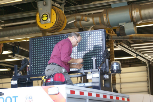
NJDOT’s top priority is to improve highway safety. To support this goal, in September 2018, New Jersey began a pilot study of the effectiveness of using connected vehicle technology to alert the motoring public to the presence of safety service patrol (SSP) workers at incident sites.  With the support of the NJ State Innovation Council (NJ STIC) and a STIC Incentive Funding grant of $39,600 awarded by FHWA, NJDOT piloted the use of Beacon Hazard Lights technology on 32 safety service vehicles to alert drivers to the presence of workers via the mobile navigation app Waze. The device, which is produced by iCone, uses GPS location and wireless communication technology to transmit the location of the SSP vehicles to the iCone Data Server in the cloud where it can be picked up by Waze. Together with the New Jersey Institute of Technology’s (NJIT) ITS Resource Center, NJDOT published a final report of their findings from the pilot project in December 2019, available here.

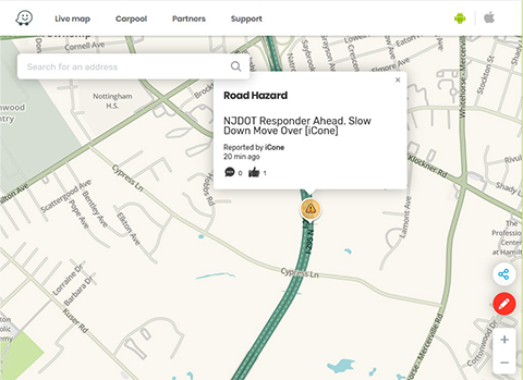
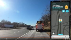
The SSP location and message shown on the Waze.com website. Photo Source: Cowan et al., 2019.

The primary goal of the study was to test the feasibility of the iCone technology on SSP vehicles by analyzing the time elapsed between device activation and Waze notification, to examine the Verizon 4G cellular network strength for potential coverage loss that could result in service disruption in communication, and to analyze the effectiveness of the equipment through several testing means. The methods of evaluation to complete these objectives were field and remote testing of the technology and documentation of the equipment installation and repairs. Field testing was conducted from January to October 2019 by activating the iCone-enabled SSP truck hazard lights and Dynamic Message Board (DMS) at 2-mile intervals along the entire 280-mile SSP coverage area. An analyst conducted remote testing through monitoring of the iCone and Waze web-based interfaces.

The results of field testing showed that, on average, communication with Waze was successful 76 percent of the time, 20 percent of the time the device communicated with the iCone Data Server but not Waze, and the remaining 4 percent of the time the device did not transmit its location to the iCone Data Server or Waze. The average time elapsed from the iCone device activation to its appearance in Waze was 2 minutes and 41 seconds. On two days of testing along the SSP coverage area, there was no communication between the iCone device and iCone Data Server or Waze.

In addition to field testing, analysts conducted remote testing of 85 active instances of the iCone device by observing the iCone and Waze web portals. In 59 percent of these 85 instances, the active iCone device was detected in Waze, with 29 percent of these successful detections showing the exact timestamp in both Waze and iCone. These results were shared with Waze so that the company could address the issues related to missing and delayed data transmission. For equipment evaluation, results showed that by April 2019, 12 of the units had technical problems that were attributed to the winter weather conditions in New Jersey including snow, road salt, and extreme cold. The iCone engineering team was responsive to the issues and re-evaluated the device design so that replaced units could withstand the weather conditions. A prototype of the newly-designed replacement devices was delivered to NJDOT in December 2019 and has been installed in five of the vehicles.

The installation of the device on an SSP vehicle by an iCone technician. Photo Source: Cowan et al., 2019.

The researchers believe that this technology evaluation pilot project was the first of any state DOT to seek to inform the public of SSP patrol vehicle locations with the sole objective of increasing safety.  The pilot project provided valuable analysis and lessons learned to inform next steps for NJDOT. Testing and analysis of installed devices and their replacements will continue until the end of the product warranty period on September 1, 2021. Additionally, researchers recommended further investigation of the disruptions and delays in the communication path from the iCone device to Waze.  Additional coordination with each technical partner during the steps of the testing process could help to identify the cause of service disruptions.

During the study, NJIT and iCone were unable to obtain Waze data showing how many people clicked the “thumbs up” to the message on the app. Future analysis should investigate how to gather reactions of the motoring public to Waze notifications. The researchers recommended exploring partnerships with crowdsourcing GPS navigation providers to further learn how drivers are reacting, which should include a data transfer process and strategies for reducing latency between iCone data server and Waze.

The Final Report contains additional information on the purpose of the research, the role of various stakeholder organizations in the research, a description of the technology devices and tools procured and used in the research, and the evaluation results.  The Final Report was submitted to the FHWA and is available to review here.

Featured Image Source: NJDOT, 2019.

Connected Vehicles Program Pilot Testing of Technology for Safety Service Patrol Workers Continues

Video screenshot of hazard display message received

The rise of crowdsourced navigation applications and connected vehicle applications provide new opportunities to relay road service safety information to the motoring public.  NJDOT has initiated a Connected Vehicle: Road Service Safety Message pilot study that evaluates the effectiveness of using connected vehicle technology to alert the motoring public to the presence of safety service workers at an incident site. NJDOT is piloting the use of a Beacon Hazard Lights technology to alert drivers to the presence of workers when safety service vehicles turn on their hazard lights. The piloting of the technology has received the support of the NJ State Innovation Council (NJ STIC) and a STIC Incentive Funding grant of $39,600 awarded by FHWA.

The primary objective behind the initiative is to inform the public of the presence of Safety Service Patrol (SSP) personnel thru various services and applications that share real-time traffic and roadway information once they have responded to an incident or to help a motorist.  A short demonstration video of how a technology-equipped NJDOT safety service vehicle interfaces with crowdsourcing platforms in the field can be accessed here.

Periodic interim reports for the pilot study are being prepared to evaluate the technology’s application during the STIC grant period. Previously, NJDOT and New Jersey Institute of Technology (NJIT) personnel conducted a field evaluation of the technology following the device-equipped SSP vehicle then subsequently maintained a data log of the device’s activity in the field and through mobile and web-based interfaces.  In continuation of this effort, the NJIT team proceeded with a similar analysis by studying the correlation between the data recorded via the device log and the crowdsourced navigation applications web-based interface. In addition, the radio logs maintained by the Safety Service Patrol were used to further support this evaluation effort.


New Jersey Pilots Connected Vehicles Program to Protect Safety Service Patrol Staff

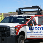
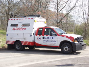
NJDOT safety service patrol vehicle. Source: NJDOT

Each day New Jersey’s safety service patrol (SSP) workers put their own safety at risk to assist motorists in need and to assist other first responders. In addition to warning other motorists about recent traffic incidents, they remove disabled vehicles, provide gasoline, and perform vehicle repairs. Safety service patrol workers use temporary signage, traffic cones, flares, and portable variable message signs (PVMS), existing overhead message signs, the NJ511 phone and website systems as well as the SafeTrip application to warn motorists about their presence.

Unfortunately, collisions involving safety service patrol workers still occur. Cars often travel at excessive speeds near staff who work on the scene of such collisions. In 2015, the Federal Highway Administration (FHWA) reports that a work zone crash occurred once every 5.4 minutes in the United States. The impact of crashes can be catastrophic. Every day 70 work zone crashes occurred that resulted in at least one injury, while every week 12 work zone crashes occurred that resulted in at least one fatality. The NJDOT’s continued efforts to reduce work zone fatalities since the 1990s has resulted in one of the lowest rates in the nation. Despite this, at least one service worker has died in a New Jersey work zone each year since 2007. In 2016 seven fatal crashes occurred in New Jersey work zones, including the death of one service worker.

The automobile manufacturing industry is in the technology development phase of putting connected and automated systems fully in place.  Once deployed, first responders and/or their response vehicles would be detected by these systems to prevent crashes resulting from oncoming traffic.  Until those systems are deployed, the most used applications to alert motorists to roadside incidents, stopped police vehicles and other types of hazards is by Google, Waze, or HERE.

To help ensure the safety of service patrol staff, NJDOT has initiated a pilot study that will examine the effectiveness of using connected vehicle technology to alert the motoring public to the presence of safety service workers at an incident site. Starting in September 2018 NJDOT will pilot the use of a Beacon Hazard Lights technology to alert drivers to the presence of workers when safety service vehicles turn on their hazard lights. The piloting of the technology has received the support of the NJ State Innovation Council and a State Innovation Council Incentive Funding grant of $39,600 awarded by FHWA.  More information about the STIC Incentive Funding source can be found here.

According to Ross Scheckler, the managing partner of iCone, the product supplier for the hazard light technology to be piloted in the NJ study, the firm seeks to build technologies that will increase the availability of data about work zones to the traveling public.  Their tools alert drivers in real-time to the presence of workers, lane-closures and construction related back-ups by making them available on the cloud, where state traffic centers and navigations companies like HERE and Waze can pick them up.  A primary goal of the technology is to let drivers of vehicles know that the rescue truck or the flagger is in the road miles ahead so that the driver or the automation system can slow down and move over, or maybe choose a different route.

In the New Jersey pilot program, the iCone technology will transmit the location of worker vehicles within two minutes of the activation of a vehicle’s hazard lights. The location updates every 15 minutes and is re-transmitted if the vehicle moves more than 500 feet.

Data from 31 SSP vehicles will alert drivers via 511NJ as well as mapping & traffic apps

Thirty-one Safety Service Patrol (SSP) vehicles in Harding and Cherry Hill Yards will pilot iCone’s GPS technology to alert drivers using the 511NJ website and mapping, and traffic apps including Google Maps, Waze, and Here.  A Texas DOT study found that deploying iCone’s traffic beacons reduced crashes at a busy highway up to 45 percent (WorkZoneSafety.org). In addition, beacons deployed on roads resulted in crash cost reductions between $6,600 and $10,000 per night. Arlington is one of more than 450 partners including city, state and country government agencies, nonprofits and first responders to partner with the Waze Connected Citizen Partner program, a free data-share of publicly available traffic data, to deliver road and construction work information to cars.

Different states have used iCone’s technology in various ways, according to Mr. Sheckler. For example, Nevada has focused on relaying lane closures through iCone’s “Smart Arrow Board” modification product. Colorado on the other hand, has focused on the location of traffic cones around work zones through the ‘iPin’ product.  New Jersey’s initiative will examine the effectiveness of iCone’s technology on service patrol vehicles.

One benefit of the approach being tested is that the data appears to be comparatively low-cost and effective in reaching the traveling public through available traffic flow applications.  Mr. Scheckler, iCone’s product supplier representative, notes that most states can quickly accommodate to the data flow that the firm produces since the data feed is modeled off the Waze format.  “When states aren’t ready to integrate the data flow, the data still goes out to millions of cars through partners like Waze, HERE and Panasonic. This works so well that in states that haven’t started picking up the feed, we still have contractors using our equipment because they want their workers to show up in the car.”

iCone’s Vehicle Hazard Light Radio Adaptation GPS device. Source: iCone

In New Jersey, one of the program’s goals is to enhance awareness of the State’s Move Over Law enacted in 2009. The law requires a driver who sees an emergency safety vehicle to approach cautiously and, if possible, make a lane change into a lane not adjacent to the emergency vehicle. Emergency safety vehicles include those operated by fire or police departments, ambulance services, tow trucks and highway maintenance or emergency service vehicles, many of which display flashing yellow, amber or red lights. Drivers must create an empty lane of traffic or prepare to stop, if possible, or face fines of no less than $100 and a much as $500.

NJDOT plans to evaluate the success of the program during Year 1 and determine interest and opportunities for collaboration with transportation agencies in other states and first responder organizations. NJDOT is part of TRANSCOM (XCM), a coalition of 16 transportation and public safety agencies that improves communication and technology by the use of traffic and transportation management systems and in partnership with technology companies. XCM currently provides NJDOT incident data to Google, Waze, and Here as well as the 511NJ web and phone platform, however SSP vehicle location data is not integrated into any of these programs.

Sources:

Cowan, S. (2018). Spring 2018 STIC presentation: Connected Vehicle — Road Service Safety Messages. Retrieved from: https://www.njdottechtransfer.net/wp-content/uploads/2018/04/CIA-Team.pdf
Hsieh, E. Y., Ullman, G. L., Pesti, G., & Brydia, R. E. (2017). Effectiveness of End-of-Queue Warning Systems and Portable Rumble Strips on Lane Closure Crashes. Journal of Transportation Engineering, Part A: Systems, 143(11), 04017053. Retrieved from:  https://ascelibrary.org/doi/abs/10.1061/JTEPBS.0000084

National Work Zone Safety Information Clearinghouse. (c2016). 2016 New Jersey Work Zone Fatal Crashes and Fatalities. Retrieved from https://www.workzonesafety.org/crash-information/work-zone-fatal-crashes-fatalities/#new%20jersey

Ullman, G. L., Iragavarapu, V., & Brydia, R. E. (2016). Safety effects of portable end-of-queue warning system deployments at Texas work zones. Transportation Research Record: Journal of the Transportation Research Board, (2555), 46-52. Retrieved from https://doi.org/10.3141/2555-06

Road Diets Are Making Roads Safer in New Jersey

Across the country and in some New Jersey municipalities (at least 50 in the last six years), road diets have been implemented as a low-cost safety countermeasure for motorists and non-motorists alike by reducing travel lanes, vehicle speeds and freeing up space for bicycles and pedestrians. Road diets are recognized by the Federal Highway Administration (FHWA) as one of twenty “Proven Safety Countermeasures” to reduce serious injuries and fatalities on American highways and roads.

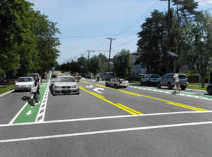
According to the FHWA, a road diet most commonly involves converting an existing four-lane undivided roadway to a three-lane roadway consisting of two through lanes and a center two-way left-turn lane.

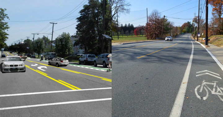
Digitally-enhanced photo shows potential changes for Livingston Avenue in New Brunswick. From Costs and Benefits of a Road Diet Conversion, 2015.

Implemented across the US for at least two decades, road diets have become standard practice and increasingly widespread as their benefits, including economic development, have become popularized. Studies indicate a 19-47% reduction in overall crashes when a road diet is installed on a four-lane undivided facility. For some roadways, these improvements have reduced crashes by up to 70% (See Reston, Virginia case study).

In New Brunswick, a partial road diet has been installed on Livingston Avenue, prompted by concerns expressed by many residents in 2014 when three children in a crosswalk were struck by a vehicle. There are plans for a complete road diet in the future. According to the Middlesex County Engineer’s Office, the project is currently obtaining federal aid and state approval to begin work. This road diet was supported by a cost-benefit evaluation that found the benefits of safety improvements would overwhelmingly exceed the costs over a 20 year period.

In Burlington City, NJDOT implemented a road diet on Route 130 to create a buffer for vehicles and pedestrians after many years of work with local officials. For six consecutive years, the Tri-State Transportation Campaign named Route 130 as the state’s most dangerous road for walking with 11 pedestrians killed by vehicles between 2012 and 2014. These hazardous conditions particularly affected students, who had to cross the divided highway to get to Burlington High School. The death of 17-year old Antwan Timbers, a sophomore at the school, inspired classmates to fight for safer streets around their school and state with the “25 Saves Lives” campaign, which advocated for legislation to reduce speed limits to 25mph near school zones along Route 130. The road diet reduced the roadway from six lanes to four lanes. Large “School Speed Limit 25mph” signs and “No Turn On Red” signs were also installed at busy intersections. Additional improvements are planned for the spring of 2018.

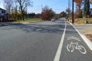
Passaic County’s road diet in Wayne has resulted in reduced dangerous crashes.

In Woodbury, NJDOT converted Route 45, a multi-lane roadway into a road with one travel lane in each direction, a left turn lane and bicycle lanes. According to the FHWA, the roadway was plagued with excessive speeding, improper lane changes, parking difficulties, and safety concerns. The road diet succeeded in reducing crashes and vehicle speeds while helping pedestrians feel safer. The improvements had no negative effect on emergency vehicle response times, which had been an initial concern of the Woodbury Police.

Passaic County has been active in installing road diets on several of their oversized suburban throughways. In 2016, case study research examined more closely the approaches that the County had taken and explored the lessons that they learned and some outcomes of implementing successful road diet projects. For 2018, the County is working with the North Jersey Transportation Planning Authority to bring road diets to three additional corridors – including narrowing a roundabout.

In Ewing, NJDOT and Mercer County and other local partners are conducting a study to identify and recommend improvements to make Parkway Avenue, near NJDOT headquarters, a safer corridor. Parkway Avenue was one of two corridors (out of 99 potential locations) identified as a feasible, suitable and beneficial location to implement a road diet in NJDOT’s 2015 Road Diet Pilot Program. The public may keep up to date and share input on the Parkway Avenue Safety website.


See more information on how road diets work, the benefits they provide, and New Jersey case studies: