NJDOT’s Next-Gen Approach to Mobility and Operations: Q&A Interview with CIA Team Lead

We recently spoke with Vandana Mathur, Supervisor of Transportation Mobility & Research at NJDOT, to learn more about the agency’s ongoing innovative mobility and operations initiatives. The discussion navigated advancements such as enhanced IMR truck equipment for safer incident response, real-time weather monitoring through the Weather Savvy program, and smart truck parking technology to address parking space shortages. These efforts reflect NJDOT’s commitment to using data-driven, next-generation solutions to improve roadway safety and efficiency across the state.


Q. Can you tell us about the initiative to equip NJDOT Incident Management Response (IMR) trucks with lighting towers and LED flares at incident scenes as part of the EDC-7 Next-Generation TIM – Technology for Saving Lives?

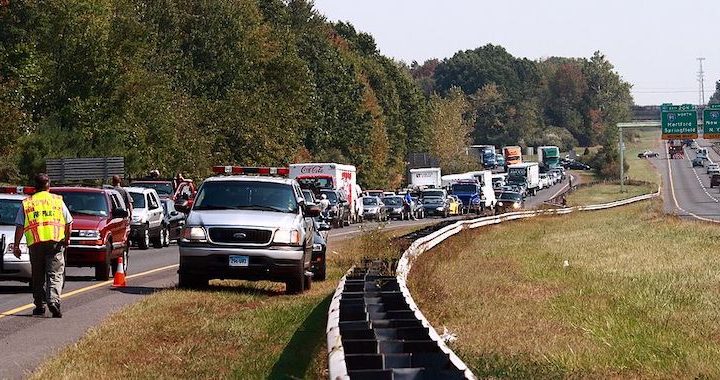
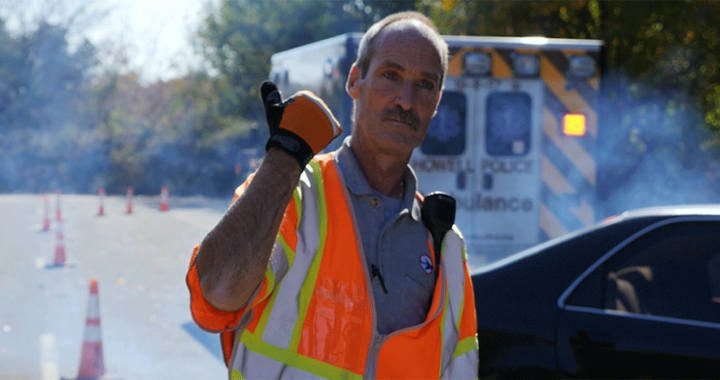
A. NJDOT secured funding from the Federal Highway Administration (FHWA) to enhance its Incident Management Response (IMR) trucks by equipping them with light towers and LED flares. This initiative has already significantly improved NJDOT’s on-scene operational capabilities—particularly in low-light conditions—by increasing both safety and efficiency. The light towers provide critical illumination, enabling first responders to better assess the scene, identify debris, and evaluate the extent of the crash. The improved visibility also enhances personnel safety by alerting approaching drivers to the presence of an emergency scene, giving them time to slow down and avoid secondary incidents.

LED flare deployed at an incident site

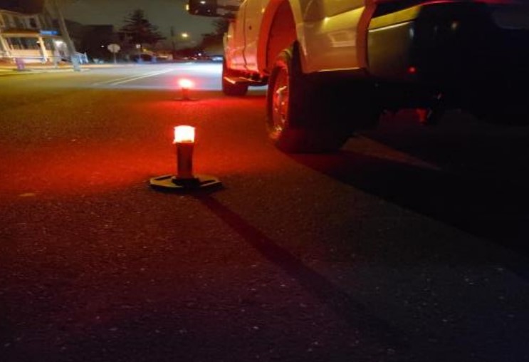
Unlike traditional emergency lights, which can be blinding, the LED flares equipped on NJDOT’s IMR trucks use a calmer, sequential lighting pattern that is less jarring to drivers while still maintaining a strong visual presence. The light towers provide wide-area illumination that surpasses the limited reach of standard vehicle emergency lights, ensuring that all personnel working at the scene are clearly visible. Designed for quick deployment, the towers deliver lighting rapidly when it’s most needed.

This initiative plays a critical role in supporting Traffic Incident Management (TIM) by enhancing the safety for both emergency responders and drivers during roadway incidents.

Q. You mentioned the benefits of the lighting towers and LED flares compared to traditional flashing lights – are emergency responders moving away from using flashing lights altogether? Additionally, have they been installed and implemented into all NJDOT IMR trucks or is this an ongoing process?

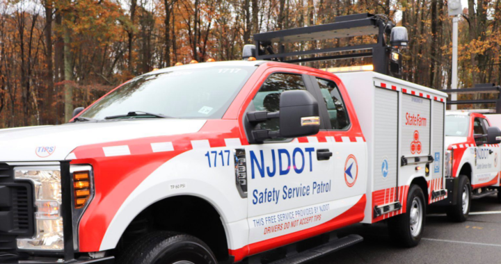
A. Yes, we often use the new tools instead of the flashing lights, especially because they can be deployed immediately. We have installed the lighting towers and LED flares on 22 IMR trucks across the state. These tools are used frequently—on average, once per week or several times per month—which shows they’re a valuable and necessary source for incident management. Because they have proven so effective, it is now standard practice to include light towers and LED flares on all new IMR trucks added to the fleet.

Q. Staying on TIM, can you describe the Drivewyze alert project? How does it collect and distribute data, and what are some potential benefits?

A. Drivewyze is a product that we are purchasing through the University of Maryland as part of the Transportation Data Marketplace (TDM) and the Eastern Transportation Coalition, which benefits New Jersey and the 19 other coalition member states. Drivewyze sends safety alerts to commercial vehicles’ Electronic Logging Devices (ELDs)—which all truckers have—and since the alerts are free, both drivers and fleet operators can sign up to receive them.

The system generates alerts using INRIX data and provides warnings for low bridges, high rollover zones, weight restrictions, “no trucks in left lane” zones, and sudden slowdowns and congestion. Because commercial vehicles need more time to stop than passenger vehicles, due to their size and weight, timely slowdown warnings can be especially critical for safety.

Drivewyze dashboard displaying the number of alerts, the type of alerts, and where the alerts are located

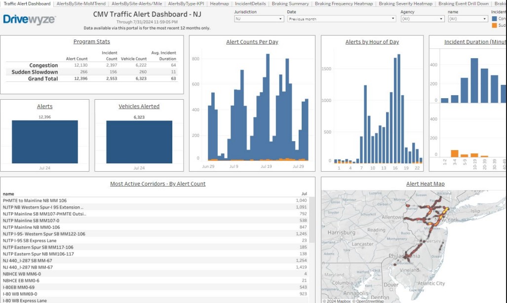
As part of its service, Drivewyze provided us with a dashboard that show the number of alerts sent, categorized by alert type. We use this data to assess performance. For example, by reviewing the number of alerts issued over the past three months, we evaluate whether alerts are being sent to the right places at the right times. When I joined the NJDOT team, I emphasized the importance of verifying and validating this data—not just accepting numbers that look good on paper.

We reached out to NJIT, our resource center, to help us conduct real-world testing during peak hours to confirm whether the alerts were actually reaching vehicles on the road. Initially, NJIT found that static alerts were working well, but congestion alerts were not coming through. When I contacted Drivewyze, they responded that they had forgotten to enable congestion alerts and said they had fixed the issue. NJIT conducted follow-up test runs in April to confirm the fix.

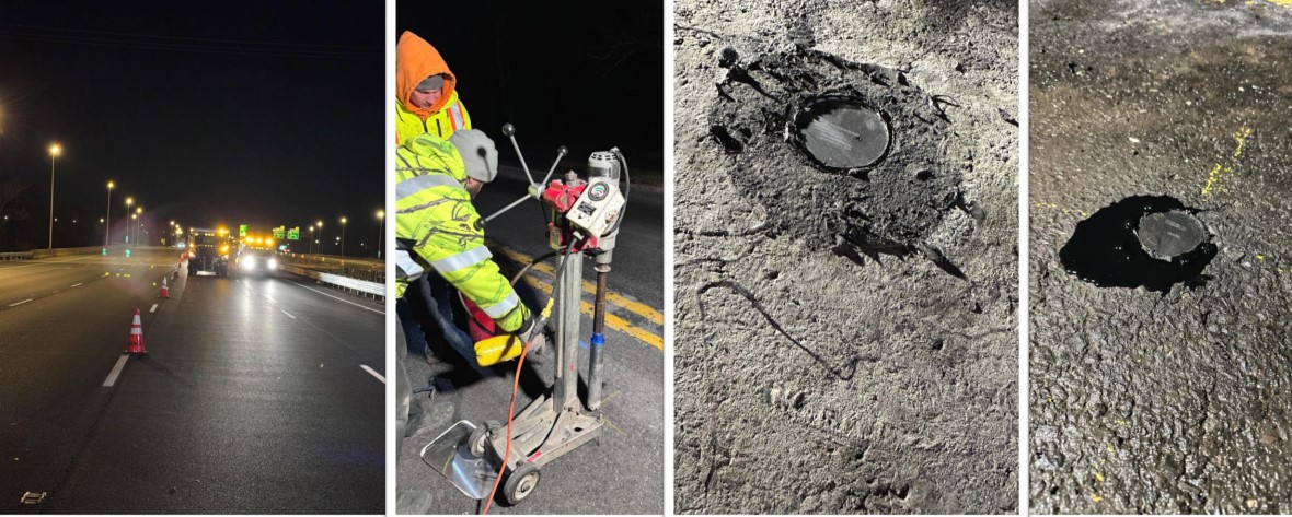
In the second round of testing, static alerts continued to perform well—NJIT even received a new static message related to a closure of Exit 34 due to a sinkhole. However, congestion alerts still underperformed. Despite driving through 83 congestion zones at speeds under 25 mph, NJIT researchers only received 5 congestion alerts. We will continue working with Drivewyze to make sure this issue is fully resolved.

Q. Moving to a different topic, at the most recent NJ STIC meeting you mentioned recent advancements in the Weather Savvy pilot. What technologies are used in the Weather Savvy program, what benefits does it provide, and how has it evolved since it first began?

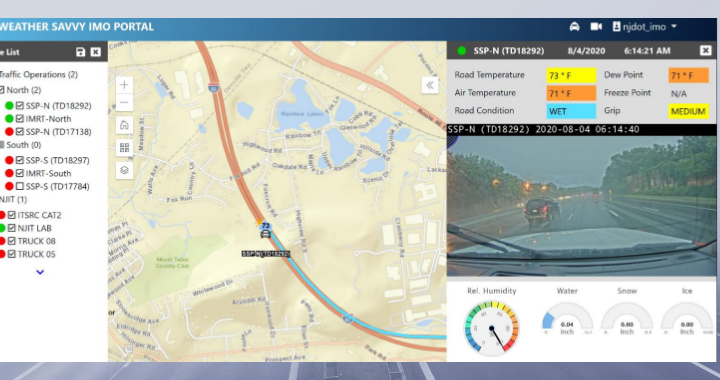
A. We launched the Weather Savvy pilot project in 2020 to gain real-time situational awareness of roadway conditions. We began by equipping 12 NJDOT vehicles with Vaisala MD30 weather sensors. These sensors collect a range of data such as air temperature, road surface temperature, grip levels, frost point, dew point, and whether the road surface is wet, icy, or dry. Each vehicle also contains tablets that display this information to the driver and relays it to a central server, administered by NJIT, via a wireless router installed in the vehicle. A road-facing camera mounted on the vehicle provides real-time video of roadway and weather conditions.

Screenshot of the Weather Savvy portal hosted by NJIT

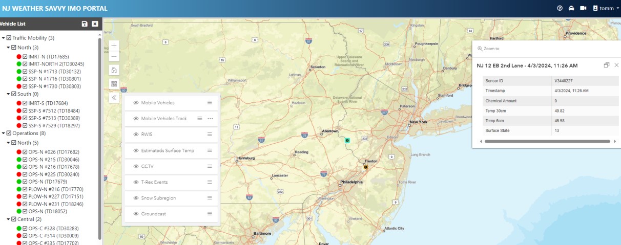
Since the project began, we have expanded from 12 to 45 NJDOT vehicles, including plow trucks, Safety Service Patrol (SSP) trucks, and operations supervisor pickup trucks. All collected data is accessible through a web portal developed by NJIT, which features a map showing each vehicle’s location, online/offline status, and travel history over the past 15 minutes. The portal also includes color-coded indicators for road surface conditions and allows users to click on specific locations for detailed information.

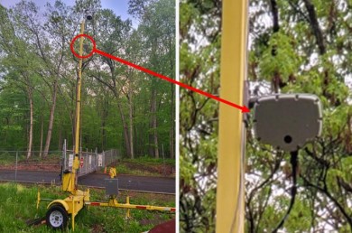
Last year, NJIT enhanced the portal by integrating additional roadside sensors, including Vaisala GroundCast and acoustic sensors. GroundCast is a battery-operated, in-pavement cylindrical sensor that collects data on surface, ground, and base temperatures, as well as the presence of roadway chemicals. The acoustic sensors record the sound of vehicles driving over the road and use an AI model to classify the road surface conditions. All of this data has been integrated into the Weather Savvy web portal to support better live monitoring of road conditions.

NJDOT workers installing Vaisala GroundCast into the pavement

Right now, we are working toward integrating three sources of weather data: the mobile Weather Savvy vehicles, stationary road sensors across the state, and potential virtual Road Weather Information Systems (RWIS) data. Our goal is to merge all three sources to create the most accurate, real-time understanding of road and weather conditions. This phase is still in the early pilot stage.

Q. Is NJIT’s Weather Savvy web portal publicly accessible, or is it only shared with NJDOT?

A. Right now, the Weather Savvy web portal is internal-only, since it’s still a pilot project. We want to ensure that we have a solid, data-driven foundation before releasing any information to the public. That said, it has been really exciting to see how the data comes together. I have shared many images during STIC and other state meetings to give people a look at the portal. It is a very cool and innovative project. In fact, NJDOT, NJIT, and our technical partners from Vaisala and EAI won the 2021 “Outstanding Project Award” from the Intelligent Transportation Society of New Jersey (ITS-NJ) for Weather Savvy.

Q. During the previous STIC meeting, the Mobility and Operations team mentioned that you are testing direct streaming from sensors to servers on two of the Weather Savvy vehicles. Can you explain this initiative?

A. For the Weather Savvy project, one of the challenges we’ve faced is ensuring consistent data transmission from the trucks. Since drivers are inside the vehicles managing multiple devices—including laptops and tablets—there are times when the laptops shut off or something else interrupts the data flow. With a fleet of 45 trucks, keeping them all fully operational is a year-round task that keeps us constantly busy.

To address these issues, NJIT developed an API that allows the data to be sent directly to their server, bypassing the middle steps involving the tablet, laptop, and router. At first, they planned to roll this change out across the entire fleet, but I told them to start with a small test—just two trucks—to see how well the direct data transmission works. This change will also only apply to certain vehicles; for example, the IMR trucks will keep their tablets in place.

Q. Can you describe some of the technology used in the Truck Parking Pilot, what NJDOT has implemented so far, and some next steps for the future?

A portable traffic microwave sensor deployed at the entrance of a rest area

A. For the Truck Parking Pilot, we have deployed a range of technologies to better monitor and manage available spaces. First, we use in-pavement magneto-resistive sensors—referred to as “pucks”—manufactured by a company called Sensis Networks. These sensors detect whether a truck is occupying a particular space, and because truck parking spaces are so long, we have installed two pucks per space to ensure accurate detection. In addition to pucks, we installed traffic microwave sensors—one at the entrance and one at the exit of rest areas—to help us count the number of trucks entering and exiting each site.  We also equipped the rest areas with CCTV cameras that provide live video feeds, supplementing the sensor data with visual information.

To transmit the collected data to NJIT servers, we use 4G and LTE modems, along with 4-port switches and Power over Ethernet devices. Each rest area has a dedicated equipment cabinet—installed by NJIT—that houses the pucks, cameras, and data transmission components.

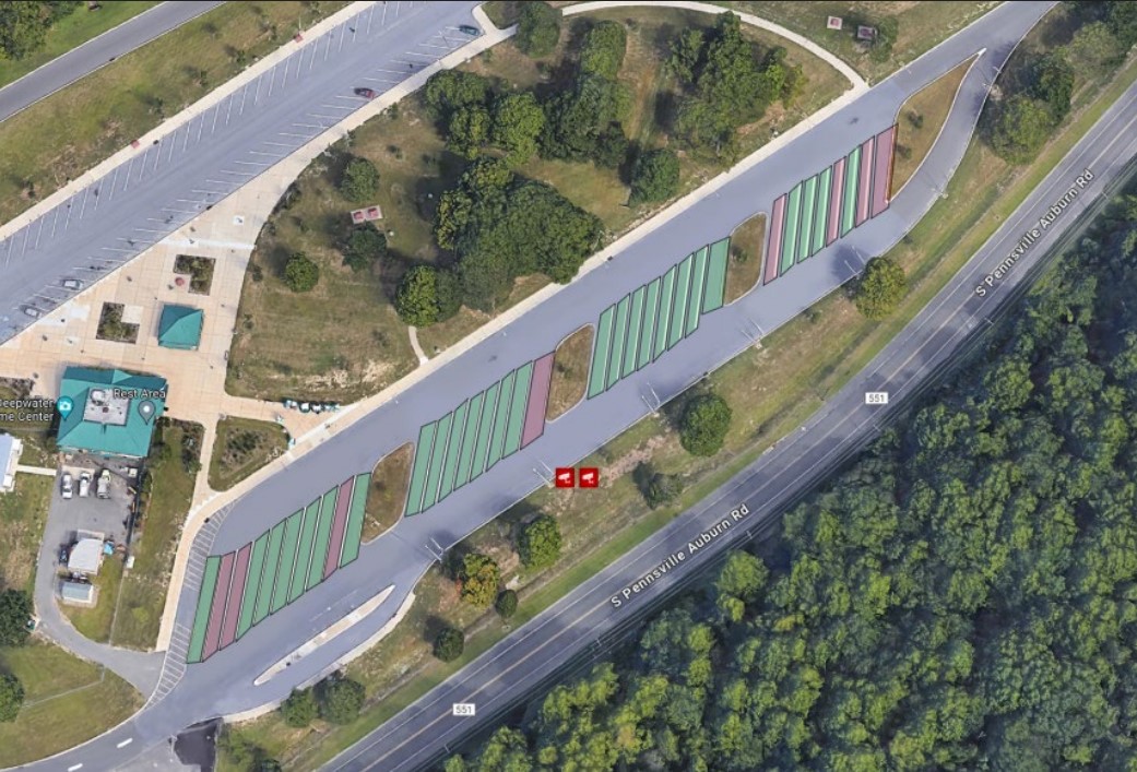
We launched our first pilot site at the Harding rest area in 2021. That site features two microwave traffic sensors at the exit and entrance, nine CCTV cameras, and 44 pucks. In 2023, we expanded to the Deepwater rest area (also known as Carney’s Point), where we installed two traffic microwave sensors, one CCTV camera, and 68 pucks. All of this data feeds into a truck parking portal dashboard developed by NJIT to provide real-time insights. The dashboard displays the number of vehicles entering and exiting each site, average dwell time for trucks, the number of vehicles currently parked, and the occupancy status of individual parking spaces. It also tracks how long each spot has been occupied and provides historical usage statistics, including peak usage times.

The Truck Parking Pilot dashboard at Carney’s Point displaying the occupied parking spaces

A virtual video wall offers live views of each rest area and shows how many trucks are currently parked and how many spaces remain available, based on the combined data sources. This is particularly valuable because truck parking demand is so high in New Jersey that drivers often end up parking at entrances, along curbs, or even perpendicular to marked spaces—creating unsafe conditions and occasionally blocking cameras.

To help address this, we have been working with NJIT to install two portable Dynamic Message Signs (DMS) near the Harding pilot site, located within five miles of the rest area on I-287 and I-78. These signs will display real-time parking availability.

More recently, we started the process of expanding the project to the Knowlton rest area. My team and I, along with NJIT, recently visited the site to begin the process of installing the necessary technologies.

Q. Are there any other projects or innovations that your or your team are working on that you would like to highlight?

A. Right now, we are focusing on expanding the existing projects we already have in place. In addition, we have started exploring virtual RWIS technology, which is still very new to us. It is currently in the early stages of development, so nothing has been substantiated yet.

Image of backed up traffic and first responder in neon vest standing on highway

Talking TIM Webinar Series (TIM) Webinar Series

The Federal Highway Administration's (FHWA) Talking TIM webinar series provides best practices, new technological innovations, and successful implementations. The webinar series provides a forum where TIM champions with any level of experience can exchange information about current practices, programs, and technologies.  Each month, the FHWA TIM Program Team seeks to feature content that highlights successful programs, identifies best practices, and showcases technology that advances the profession.

The FHWA-sponsored webinars are hosted by the National Operations Center of Excellence (NOCoE). Talking TIM typically takes place the fourth Wednesday of each month from 1:30 PM – 3:00 PM.  Click here to view upcoming webinars.

Below is a list of past webinars:

  • January 2021: The International Association of Fire Chiefs (IAFC) Role in TIM, Digital Alert Pilots in St Louis and Kansas City, and FHWA Every Day Counts Round Six (EDC-6) NextGen TIM Overview
  • February 2021: Innovative Tools for Responder and Road Worker Safety
  • March 2021: AASHTO's Role in TIM, Nebraska Tow Temporary Traffic Control Program, Fire Truck Attenuators for Temporary Traffic Control, Massachusetts Legislation for Driver and Responder Safety
  • April 2021: Wisconsin's Traffic Incident Management Enhancement (TIME) Program, City of Seattle TIM and Response Team Program, and North Central Texas Council of Governments (NCTCOG) TIM Innovations
  • May 2021: National Highway Traffic Safety Administration's (NHTSA) Role in TIM, Incident Detours Involving Railroad Crossings, Washington State's TIM Program and Virtual Coordination, and Responder Vehicle to Traffic Management Center Video Sharing
  • June 2021: Unmanned Aerial Systems (UAS) for Traffic Incident Management
  • July 2021: Lubbock Fire and Rescue Helmet Innovation,  RESQUE-1 Electric and Hybrid Vehicle Assistance, Geographically-Tagged Information from Travelers
  • August 2021: CDOT TIM for Localities, Texas Commission on Law Enforcement TIM Training Requirement, Schertz Fire and Rescue TIM Training Institutionalization, Institutionalizing TIM training for EMS Professionals in Georgia
  • September 2021: Rural Roadway Strategies for Incident Management
  • October 2021: Autonomous Truck Mounted Attenuator Testing and Implementation in Colorado, Autonomous and Driverless Pilots for Large Trucks in Arizona, Rural-Focused Towing Programs in Florida
  • November 2021: National Kickoff: Crash Responder Safety Week 2021
  • December 2021: In-Cab Incident Alerts for Commercial Vehicles
  • January 2022: Illinois TIM Program Overview and Training Video Use, Law Enforcement and First Responder Interactions Plans for Automated Driving Systems (ADS), Total Solar Eclipse Planning for 2023 and 2024
  • February 2022: Public Safety Announcements across Nine States for Motorist and Traffic Incident Responder Safety, TIM Video Sharing Use Cases: Findings from the Recent EDC-6 Next Generation TIM Workshop, TRACS and MACH: Software to Simplify Electronic Crash Reporting and Computer Aided Dispatch (CAD)
  • March 2022: Outreach for Responder Safety through Collaborations with the American Automobile Association (AAA) and the Towing and Recovery Association of America, North Carolina Tethered Unmanned Aircraft Systems (UAS) Program, and Advanced Responder Warning through Safety Vests Fueled by Video Analytics
  • April 2022: Smart Lighting Strategies for Responder Vehicles, Incident Response After Action Reviews Using Unmanned Aerial Systems (UAS) Imagery, Incident Response After Action Reviews Using Unmanned Aerial Systems (UAS) Imagery
  • May 2022: Data Use and Visualization, Promoting Roadway Safety Through Move Over Law and Responder Struck-By Awareness, The New Jersey TIM Program
  • June 2022: Ohio DOT Quick Clear Demonstration, Electric Vehicle Battery Fires and the TIM Timeline, Montana's TIM Program
  • July 2022: The National Unified Goal: What Is It and How Do We Make It Relevant?, Planning and Responding to Special Events in Minnesota, Iowa DOT TIM Program Overview and Strategies for Quicker Incident Detection
  • August 2022: Overview of the Florida Heartland TIM Committee and Florida's Expanded Deployment of Cameras on Road Ranger Vehicles, What's New for the 2022 TIM Capability Maturity Self-Assessment, The TIM National Unified Goal: Relevancy of the TIM NUG Strategies
  • September 2022:  Move Over and Responder Safety Technologies, Houston Traffic Incident Management and Training
    National Unified Goals Review and Feedback.
  • January 2023:  Mitigating Work Zone Traffic Incidents Using Unmanned Aircraft Systems (UAS), Every Day Counts Round 7 (EDC-7) Innovation, Next Generation TIM: Technology for Lifesaving Response, Traffic Incident Management National Unified Goal (NUG) Review and Feedback, Part 3
  • February 2023: Findings from Move Over Compliance and Responder Safety Technology Research, After Action Review of a Multi-Vehicle Fire, EDC-7 Summit Debrief: TIM Technologies for Saving Lives.
  • March 2023: Light-emitting diode (LED) Temporary Traffic Control Devices for Digital Motorist Alerts, Moveable Barriers and Debris Removal Systems, National Secondary Crash Research.
  • April 2023:  Responder to Vehicle (R2V) Alerts in the District of Columbia, The Role of Medical Examiners in TIM, New Audience Listening Session
  • May 2023: Highway to the Danger Zone, North Carolina's Rural Safety Service Patrol and TIM Program
  • June 2023: Using Apparatus to Protect Responders and Communicate with Drivers, Retrofitting Aging Fire Apparatus into Traffic Management Units with Truck Mounted Attenuator
  • July 2023: Emergency Vehicle Preemption in the Phoenix, AZ Region, Traffic Incident Management for Managed Lanes in Florida
  • August 2023: Medical Helicopter Landing Zone Considerations for Roadway Crashes, Wearable 360 Lighting: Real Roadside Visibility and Safety in a Distracted World
  • September 2023: Managing the I-40 Mississippi Bridge Closure, I-95 Bridge Collapse Response and Coordination in Pennsylvania
  • October 2023: North Carolina Department of Transportation (NCDOT) Incident Management Assistance Patrol (IMAP) Tools and Safety Service Patrol (SSP) Research Needs, SSP State of Practice: Findings from the SSP Pooled Fund Study
  • December 2023: City of Fresno Improves Emergency Response Vehicle Routing Using Their Safer Platform, Washington State Department of Transportation (WSDOT) Virtual Coordination Center (VCC)
  • February 2024: Good Practices and Current Research in Vehicle Lighting for Roadway Incidents, Changes for TIM in the Newly Released MMUCC 6th Edition and the MUTCD 11th Edition
  • March 2024: Missouri Department of Transportation (DOT) and Highway Patrol Full Scale TIM Demonstration, Active 911 on South Carolina Interstates for Faster On-Scene Traffic Incident Response
  • October 2024: Tennessee TIM Strategic Plan and Its Implementation, Effective Tool for Removing Crash and Disabled Vehicles from the Roadway
  • December 2024: Electric Vehicle Task Force: An Overview of Development, Products, and Next Steps, Electric Vehicle Incident Scene Awareness
  • January 2025: Advancing Safe, Quick Clearance for Commercial Vehicles, A Cloud-based Traffic Signal Preemption System for Safer, Quicker Emergency Response
  • February 2025: Jason Dicembre - Maryland Department of Transportation, Dr. Darcy M. Bullock - Purdue University
  • March 2025: Texas' Statewide TIM Program, Minnesota's Freeway Incident Response Safety Team (FIRST) Program

Go to Talking TIM webinar series for more recent events.

More  information on the FHWA EDC-7 initiative, Next Generation TIM: Technology for Lifesaving Response is here.

Jim AustrichPaul Jodoin, and Joe TeboFHWA Office of Operations TIM Program, organize and moderate this webinar series hosted by the National Operations Center of Excellence (NOCoE).


Developing Next Generation Traffic Incident Management in the Delaware Valley

Traffic Incident Management (TIM) programs help first responders and traffic operators to better understand and coordinate roadway incidents. As part of the sixth round of the Federal Highway Administration’s (FHWA) Every Day Counts (EDC) initiative, the agency is promoting innovative practice in this area through NextGen TIM. These practices and procedures can advance safety, increase travel reliability, and improve agency operations by engaging with new technologies and trainings. For example, sensors and crowdsourced data can help traffic agencies better detect incidents and decrease response times. Drones, or Unmanned Aerial Systems (UAS) can help transportation agencies and first responders better understand the incident scene and speed the resumption of traffic flow. The NextGen TIM initiative is an effort to improve traffic incident management through technological innovation and standardized operating procedures. NextGen TIM technologies and practices are currently being used in the Delaware Valley to increase real-time situational awareness and ensure maximum safety at the scene of an incident.

Regional Integrated Multimodal Information Sharing (RIMIS)

Image of RIMIS Operational Tool, which is a map of the DVRPC region, with Philadelphia at the center, and portions of New Jersey to the east, and Pennsylvania to the West, highway routes are marked in green and yellow, yellow denoting slower than usual operations, orange construction worker signals denote construction along the corridor, many of them are clustered aroudn Philadelphia.

The RIMIS Operational Tool gives a system-wide overview of traffic operations, such as incidents, traffic flow, and construction alerts, courtesy DVRPC

Currently, transportation departments in the region use the TRANSCOM traffic monitoring platform to supervise incidents. The Delaware Valley Planning Commission (DVRPC)’s version of this platform is called RIMIS, or Regional Integrated Multimodal Information Sharing. Because DVRPC is a Metropolitan Planning Organization (MPO) that spans both sides of the Delaware River, its reach includes sections of New Jersey and Pennsylvania—broadly, the greater Philadelphia area. In this region, with overlapping municipal, state, and regional jurisdictions, communication and coordination could be difficult. According to Christopher King, Manager of DVRPC’s Office of Transportation Operations Management, before RIMIS, incident notifications were commonly communicated through phone calls.

Area transportation officials recognized the need for a coordinated platform where information could be shared back and forth. Instead of slow, one-to-one incident notifications, this new, decentralized platform would present a “big picture” perspective of a traffic incident’s impacts on the regional transportation network. The concept was to create a regional centralized information location for traffic operators and first responders to view the traffic status on area roads, and understand, quickly and reliably, where an incident has occurred. Local agencies could access the platform to better understand incident conditions.

Image of 16 video feeds, each of a different stretch of highway, a video wall for traffic operations monitoring.

The RIMIS Video Wall allows for real-time roadway monitoring for first responders and traffic operations personnel, courtesy DVRPC

RIMIS was first developed nearly 20 years ago, and has proved to be invaluable as a resource. Participants supply data, such as video feeds and traffic updates, which is then aggregated to update other members. These agencies include PennDOT, NJDOT, SEPTA, and NJ TRANSIT. Member agencies and municipalities, such as Bedminster Township, PA, can take advantage of the operations database, with live and historical traffic flow and incident data, a situational map which geographically represents traffic levels and incidents across the region, and a video wall of roads in the DVRPC area with live camera feeds.

As an example, Mr. King showed a municipal fire department participating in RIMIS, that, once alerted that a collision has occurred, can access the platform’s interactive map, live video feeds, and information on planned interruptions, to better understand the scene before arriving there. The RIMIS platform gives context to first responders on route to an incident, provides a broader view for traffic operations dispatchers managing a disruption, and also assists transportation planners looking for data on how to improve a high-collision roadway.

Interactive Detour Route Mapping (IDRuM)

Image of a map of Philadelphia, with highway routes in orange, delineated into sections. Each section, when clicked on, shows two detour routes in the event of a serious incident.

IDRuM is a detour resource for rerouting traffic after major incidents, courtesy DVRPC

Another TIM tool DVRPC provides is the Interactive Detour Route Mapping (IDRuM) feature, a web application that consolidates established Emergency Detour Routes as a resource for traffic operations personnel, first responders, and transportation planners and engineers.

If, for example, an incident has occurred on a certain segment of I-295 in Bucks County, then the Primary Detour Route would involve taking Taylorsville Road south and turning right on State Route 322 to rejoin the highway, while the Secondary Detour Route would take a similar maneuver going north. This information can be easily accessed in both interactive and PDF formats on the IDRuM mapping site.

Image of two detour routes from I-295, one goes on a road to the north and then southeast to rejoin the highway, the other to the south and then northwest.

DVRPC is currently beta testing detour routes from NJDOT for the IDRuM platform, courtesy DVRPC

DVRPC is currently working to integrate NJDOT’s designated Detour Routes into the GIS map for the area east of the Delaware. The data has been uploaded, but is still in beta testing.

NextGen TIM

Mr. King says that a chief focus of NextGen TIM is to expand services such as RIMIS and IDRuM to more localities and arterial routes, as well as to ensure that all first responders are trained in the most up-to-date TIM techniques, such as how to position their vehicles for maximum safety on an active roadway.

During the second round of the Every Day Counts Initiative (EDC-2, 2013-2014),  a TIM process and training program was established under the  SHRP2, or the second Strategic Highway Research Program. This laid the groundwork for the current TIM training and organizational infrastructure, which is NJTIM in the Garden State. This consortium, spearheaded by NJDOT, provides resources and trainings to teach best practices to first responders across the state. NJDOT and the New Jersey State Police (NJSP) partner together to promote trainings and coordinate highway emergency response. To learn more about NJDOT’s efforts with regards to partnering with NJSP on crash data consolidation, using Unmanned Aerial Systems for incident analysis, and other aspects of the initiative, please visit NJDOT Tech Transfer’s NextGen TIM page.


Resources

Delaware Valley Regional Planning Commission. Interactive Detour Route Mapping (IDRuM). https://www.dvrpc.org/transportation/tsmo/idrum

Delaware Valley Regional Planning Commission. Regional Integrated Multimodal Information Sharing (RIMIS). https://www.dvrpc.org/Transportation/TSMO/RIMIS/

New Jersey Department of Transportation. Statewide Traffic Incident Management Program. https://www.nj.gov/transportation/commuter/motoristassistance/stimp.shtm

New Jersey Traffic Incident Management. Traffic Incident Management Resource Portal. http://www.njtim.org/NJTIM/

Next-Generation TIM: Integrating Technology, Data, and Training

What is Next-Generation TIM: Integrating Technology, Data, and Training?

New methods for improving Traffic Incident Management (TIM) programs aim to increase traveler and responder safety and improve trip reliability and commerce movement on all roadways.

Over 6 million reportable crashes occur every year in the United States. Each crash places responders and motorists at risk of secondary crashes while having a severe impact on congestion. New tools, data, and training mechanisms can be used to improve safety and reduce clearance times at roadway crashes. New and existing TIM programs, including those for local agencies and off-interstate applications, will benefit from using enhanced TIM practices on all roadways to save lives, time, and money.

A New Generation of TIM

While the FHWA's national TIM responder training program successfully trained almost 500,000 responders to clear incidents collaboratively, safely, and quickly, it was largely focused on agencies that respond on interstates and high-speed roadways. Next-generation (NextGen) TIM increases the focus on local agency TIM programs while integrating new and emerging technology, tools, and training to improve incident detection and reduce safety response and clearance times on all roadways.

Traditionally, transportation agencies capture incidents (crashes, roadway debris, stalled vehicles on mainlines, etc.) where sensor technologies are installed, where safety service patrols are present, or when contacted by public safety/law enforcement agencies. NextGen TIM significantly expands this capacity. It enables agencies to improve TIM strategies by implementing new options such as back-of-queue warning, navigation-app notification of active responders in the vicinity, notification-based incident detection using crowdsourced data, and more.

By using NextGen TIM methods, State and local agencies can increase traveler and responder safety, improve trip reliability and commerce movement, and enable responder communities to focus more resources on other pressing citizen needs.

Benefits

Increased Safety. NextGen TIM targets advances in safety through engineering, enforcement, education, and emergency services to help keep responders, drivers, and pedestrians safe across freeway, arterial, and multimodal travel.

Improved Travel Times. Training, data, and technology combine to help local and State agencies reduce secondary crashes and clearance times, improving trip reliability and increasing motorists' awareness of active responders along their travel routes.

Improved Operations. Integrating new and emerging technology, tools, and training can improve incident mitigation and safety throughout the whole TIM timeline, from incident detection to clearance on all roadways.

Learn more about this EDC-6 Innovation.

How NJ Incorporates NextGen Traffic Incident Management (TIM)

Stage of Innovation:
DEVELOPMENT
(December 2022)

Research. NJDOT is coordinating with State Police to determine communications that will be shared with Computer-Aided Dispatch (CAD) integration. NJDOT is also working to establish radio channels to enable coordinated DOT and law enforcement communications at incident sites.

Training. NJDOT is actively working towards achieving participation by all local agencies in the NJDOT established statewide TIM training course.

Building Support. DVRPC area-generated incident management task forces can serve as models for creation of similar diverse stakeholder task forces in other regions. NJDOT is also looking to build partnerships with media to facilitate TIM communications.

What’s Next?

For the EDC-6 initiative, the NJDOT initially wanted to focus on CAD integration as one of the major activities in support of the TIM strategic plan. As a result of NJ State Police's decision to change their CAD technology, the NJDOT is revising their approach for EDC-6 NextGen TIM.

NJDOT is continuing to coordinate with the NJIT ITS Resource Center to deploy HAAS Alert technology on NJDOT's Safety Service Patrol vehicles. The responder-to-vehicle alert application will deliver incident alerts to the motorists (i.e. phone apps) for their situational awareness when approaching a stopped SSP vehicle assisting stranded motorists to assist in reducing speed and collision.

The NJSP statewide CAD system (Motorola FLEX) is currently being re-evaluated. The NJDOT will continue to maintain the existing working group/team comprising staff from the Mobility Operations, Mobility Planning/Research, and NJIT ITS Resource Center to provide coordination and strategic planning for the CAD integration project.


Next-Generation TIM: Integrating Technology, Data, and Training: NEW & NOTEWORTHY

NJDOT Traffic Incident Management Training Course – Now Available Online as Self-Guided Course

NJDOT Traffic Incident Management Training Course – Now Available Online as Self-Guided Course

NJDOT's Traffic Incident Management training is now available as an online, self-guided course. Bringing first responder training program to online platform should make it ...
Talking TIM Webinar Series (TIM) Webinar Series

Talking TIM Webinar Series (TIM) Webinar Series

A series of FHWA-hosted webinars spotlights ongoing NextGen TIM implementations and best practices. ...
Innovation Spotlight: Testing and Deploying ITS Solutions for Safer Mobility and Operations

Innovation Spotlight: Testing and Deploying ITS Solutions for Safer Mobility and Operations

We spoke with Sue Catlett from NJDOT's Transportation Mobility, Planning and Research Group to get an update on Crowdsourcing, Weather Responsive Management and Traffic Incident ...
Developing Next Generation Traffic Incident Management in the Delaware Valley

Developing Next Generation Traffic Incident Management in the Delaware Valley

DVRPC's Traffic Incident Monitoring (TIM) platform provides system-wide traffic operators, first responders, and highway planners. ...
Final Report Released for the Connected Vehicles Program Pilot Testing of Technology for Distributing Road Service Safety Messages from Safety Service Patrols

Final Report Released for the Connected Vehicles Program Pilot Testing of Technology for Distributing Road Service Safety Messages from Safety Service Patrols

NJDOT’s top priority is to improve highway safety. To support this goal, in September 2018, New Jersey began a pilot study of the effectiveness of ...
Connected Vehicles Program Pilot Testing of Technology for Safety Service Patrol Workers Continues

Connected Vehicles Program Pilot Testing of Technology for Safety Service Patrol Workers Continues

The pilot study continues to examine the effectiveness of connected vehicle technology to alert motorists to Safety Service Patrol (SSP) workers at an incident site. ...
New Jersey Pilots Connected Vehicles Program  to Protect Safety Service Patrol Staff

New Jersey Pilots Connected Vehicles Program to Protect Safety Service Patrol Staff

This study will examine the effectiveness of connected vehicle technology to alert motorists to Safety Service Patrol (SSP) workers at an incident site. ...